Supporters, Builders, Maintainers & Land Managers of Long Loop Trail
- past supporters
Raatz and Burger Coatings
2015Sponsor
Nicollet Bike Shop
2015Sponsor
Scheels - Mankato
2015Sponsor
Jake's Stadium Pizza
2015Sponsor
AFSCME
2015Sponsor
Mankato Brewery
2015Sponsor
Lloyd Lumber
2015Sponsor
Pub 500
2015Sponsor
Long Loop Details
-
Activities
- Mountain Bike
- Hike
- Trail Running
-
Riding AreaKiwanis Recreation Area
Mankato, Minnesota -
Difficulty Rating
-
Trail TypeSingletrack
-
Bike TypeAM, XC, DJ, Fat
-
DirectionOne Direction
-
Climb DifficultyGreen
-
Physical RatingModerate
-
SeasonOpen Year Round except for Mud/Thaw
-
Dogs AllowedYes
-
TTFs on TrailBerm, Bridge, Drop, Jump, Gap Jump, Ladder Bridge, Log Ride, Roller Coaster, Skinny, Teeter Totter
-
Global Ranking#40988 in Mountain Biking
-
Local Popularity80 in Mountain Biking [+]
- 5 in Trail Running
- 5 in Hiking
-
Year Opened2013
-
Land OwnerCity of Mankato Parks Dept.
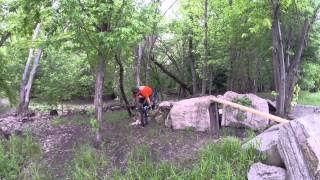
Mankato’s premier mountain bike trail is located at the Kiwanis Recreation Area just north of the Highway 169 and Highway 14 intersection. As of 2017, this trail is nearing it's final form with a few additions and refinements still on the agenda. There are two different loops at Kiwanis. The "Short Loop" shown in green is a 1 mile trail rated as beginner. The "Long Loop" is an additional 6.5+ miles of trail that is rated intermediate. A few optional loops branch off the long loop before tying back in to the main trail. These options give the rider the flexibility to give successive laps a different look. Many features have been put into the long loop for the more advanced riders; including berms, bridges, table top and gap jumps. Total mileage riding all loops is nearly 8 miles.
Access Info
Parking is at the lower gravel lot - simply drive into the Kiwanis Rec Area and onto the short gravel road, the parking lot will be on your right. There is limited parking in the paved area near the air conditioned restroom facilities.
Local Trail Association
-
Please consider joining or donating to the local trail association to supportdonate to earn trail karma!
trail development & maintenance.
Traditionally Indigenous Territory
More Stats for Long Loop mountain bike trail trail
-
Altitude change2 ft
-
Altitude min755 ft
-
Altitude max791 ft
-
Altitude start760 ft
-
Altitude end762 ft
-
Grade0.011%
-
Grade max-10.712%
-
Grade min12.555%
-
Distance climb1 mile
-
Distance down1 mile
-
Distance flat4,054 ft
-
Avg time00:28:50
-
Avg reverse time00:41:05
- view trail stats
- Unknown
- Snow Groomed
- Snow Packed
- Snow Covered
- Snow Cover Partial
- Freeze/thaw Cycle
- Icy
- Prevalent Mud
- Wet
- Variable
- Ideal
- Dry
- Very Dry
The colour categories are based on what percentage of riders are riding a trail in its intended direction.
- > 96%
- > 90%
- > 80%
- > 70%
- > 50%
- < 50%
- bi-directional trail
- no data
- < 2 days
- < 1 week
- < 2 weeks
- < 1 month
- < 6 months
- > 6 months
- Downhill Only
- Downhill Primary
- Both Directions
- Uphill Primary
- Uphill Only
- One Direction
- Description
- Photos
- Description & Photos
- Videos
- most popular
- popular
- less popular
- not popular
- mountain biking recent
- mountain biking (>6 month)
- hiking (1 year)
- moto (1 year)
- Downhill Ski
- Backcountry Ski
- Nordic Ski
- Snowmobile
Save the current map location and zoom level as your default home location whenever this page is loaded.
SaveLong Loop Trail Reports
Recent Ridelog Activity on Trail
- 0 rides
- 0 rides
- 227 rides
- Last: Jan 30, 2025
Photos
Reviews / Comments
No reviews yet, be the first to write a review or ask a question.
Use trail reports to comment on trail conditions.
We hope you've been enjoying Trailforks!
Create a FREE account to view trail comments and much more.
Videos

Nearby Trails
- Nono Trail 135 ft
- Deer Lounge 541 ft
- Paul Bunyan 1,125 ft
- Short Loop 1,532 ft
- Rex Macbeth River 1,542 ft
Kiwanis Recreation Area
- By duggus MAMB & contributors
- #27225 - 2,228 views
- follow/subscribe
- login to download gpx or kml files.
You must enter a description before submitting.