more stats
1.1 miles
Distance
-435 ft
Descent
00:09:46
Avg time
-435 ft
Altitude change
1,501 ft
Altitude min
1,937 ft
Altitude max
1,937 ft
Altitude start
1,503 ft
Altitude end
-7.4%
Grade
-25.2%
Grade max
-0.5%
Grade min
1 mile
Distance down
95 ft
Distance flat
00:09:46
Avg time

MacAttack Details

  • Activities
    • Mountain Bike
    • Adaptive Bike
    • Trail Running
    • Backcountry Ski
  • Riding Area
    Victory Hill Sector
    Victory, Vermont
  • Difficulty Rating
  • Local Popularity
    85 in Mountain Biking [+]
    • 5 in Trail Running
    • 5 in Backcountry Skiing
  • Global Ranking
    #57080 in Mountain Biking
  • Hiking SAC Scale
    T1 Hiking
  • Trail Type
    Singletrack
  • Bike Type
    AM, XC, Adaptive MTB
  • Direction
    Downhill Primary[+]
    Popular In Reverse
    • Downhill Primary for Trail Running
    • Downhill Primary for Backcountry Skiing
    • Downhill Primary for Adaptive Biking
  • Climb Difficulty
    Blue
  • Physical Rating
    Moderate
  • Trail Visibility
    Always easy to follow
  • eBike Allowed
  • TTFs on Trail
    Berm, Bridge, Gap Jump
  • Year Opened
    2017
  • Land Owner
    Conservation Collaboratives

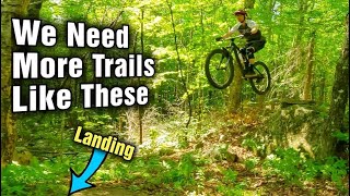
Flowy two way XC trail with towns of nice little berms and rock features. Its' upper part which starts at Upper Bench is a rougher faster more DH style and difficult to climb. The main section is very climbable

This trail is unsanctioned.

Traditionally Indigenous Territory

Recent Activity on Trail

Past Week
  • 0 rides
  •  
6 Months
  • 0 rides
  •  
All
  • 114 rides
  • Last: Jun 14, 2026
c1c2c3c4
January
February
March
April
May
June
July
August
September
October
November
December
update trails status or condition

MacAttack Trail Reports

statusdatedescription
Jul 4, 2025 @ 10:51am
Jul 4, 2025
Oct 16, 2022 @ 1:33am
Oct 16, 2022
Leaves were just removed from the trail. Perfect.
Aug 11, 2018 @ 8:36am
Aug 11, 2018
more »
Status:
on Jul 4, 2025
Ideal
Avg: 4.15 (7 votes)
Your vote: 0

view (726)
close
3D
Trail Conditions
  • Unknown
  • Snow Groomed
  • Snow Packed
  • Snow Covered
  • Snow Cover Partial
  • Freeze/thaw Cycle
  • Icy
  • Prevalent Mud
  • Wet
  • Variable
  • Ideal
  • Dry
  • Very Dry
Trail Flow (Ridden Direction)
Trailforks scans users ridelogs to determine the most popular direction each trail is ridden. A good flowing trail network will have most trails flowing in a single direction according to their intension.
The colour categories are based on what percentage of riders are riding a trail in its intended direction.
  • > 96%
  • > 90%
  • > 80%
  • > 70%
  • > 50%
  • < 50%
  • bi-directional trail
  • no data
Trail Last Ridden
Trailforks scans ridelogs to determine the last time a trail was ridden.
  • < 2 days
  • < 1 week
  • < 2 weeks
  • < 1 month
  • < 6 months
  • > 6 months
Trail Ridden Direction
The intended direction a trail should be ridden.
  • Downhill Only
  • Downhill Primary
  • Both Directions
  • Uphill Primary
  • Uphill Only
  • One Direction
Contribute Details
Colors indicate trail is missing specified detail.
  • Description
  • Photos
  • Description & Photos
  • Videos
Trail Popularity ?
Trailforks scans ridelogs to determine which trails are ridden the most in the last 9 months. Trails are compared with nearby trails in the same city region with a possible 25 colour shades. Think of this as a heatmap, more rides = more kinetic energy = warmer colors.
  • most popular
  • popular
  • less popular
  • not popular
ATV/ORV/OHV Filter
Max Vehicle Width
inches
US Cell Coverage
Legend
cell carrier legend

Radar Time
Activity Recordings
Trailforks uses anonymized public activity data. ?
Activity Recordings
Trailforks uses anonymized public activity data. ?
Personal Heatmap
Activity Types
all / none
Options
2
Date range month
Winter Trails
Warning A routing network for winter maps does not exist. Selecting trails using the winter trails layer has been disabled.
Missing Trails
Most Popular
Least Popular
Trails are colored based on popularity. The more popular a trail is, the more red. Less popular trails trend towards green.
Jump Magnitude Heatmap
Heatmap of where riders jump on trails. Zoom in to see individual jumps, click circles to view jump details.
BC Backroad Status

Service Road Atlas is a free to use, community-driven service for viewing and creating reports on the numerous back-country service roads around B.C. and Alberta.

map legend
Slope Aspect
Direction the slope faces
Flat N NE E SE S SW W NW
Trails Deemphasized
Trails are shown in grey.
disable
Only show trails with no bike usage.
Enable
Suggested Layers
Based on selected activity type

    Save the current map location and zoom level as your default home location whenever this page is loaded.

    Save
        Directions to macattack trailhead (44.558720, -71.864940)

        Photos

        No photos have been added for MacAttack yet, add a photo.

        Videos

        2 more »
        youtuber Quite Possibly The Best Trails in New England...
        20:11 | 282 | Nov 16, 2022 , Victory
        Earn Your Turns | Day Two- Victory Hill |...
        8:25 | 619 | Oct 21, 2018 , Victory

        Routes with this trail

        57 miles 12,505 ft 118 Loop
        We will ride for glory, freedom, and the dignity of the working man. Four laps to the top of Burke, four...

        4 Reviews & Comments


        We hope you've been enjoying Trailforks!

        Create a FREE account to view trail comments and much more.

        • #134975 - 1,330 views

        Frequently Asked Questions About MacAttack

        Where is MacAttack located?
        MacAttack is located in Victory Hill Sector, Victory, Vermont, United States. It is part of the Victory Hill Sector trail network. The trailhead is located at coordinates 44.55872, -71.86494.
        How hard is MacAttack?
        MacAttack is rated as Blue difficulty. The physical rating is Moderate. The average grade is 7.4%. The climb difficulty is rated Blue.
        What is the elevation gain for MacAttack?
        The trail has 435 ft of elevation descent. The elevation ranges from 1,501 ft to 1,937 ft.
        Is MacAttack a point to point trail?
        MacAttack is not a point to point trail. The direction is Downhill Primary. The trail type is singletrack.

        Hit the Trail

        Open in App

        Get this trail on your phone instantly.
        open trail in app

        Download Trail

        Save to wishlist, Garmin & download.
        save the trail

        Find Related Routes

        Find routes and users activities that include this trail.
        find routes for this trail

        You must enter a description before submitting.