more stats
3,911 ft
Distance
33 ft
Climb
-298 ft
Descent
00:14:56
Avg time
-265 ft
Altitude change
3,050 ft
Altitude min
3,314 ft
Altitude max
3,314 ft
Altitude start
3,051 ft
Altitude end
-6.8%
Grade
-49.9%
Grade max
10.1%
Grade min
495 ft
Distance climb
2,740 ft
Distance down
676 ft
Distance flat
00:14:56
Avg time

Mega Zen Details

  • Activities
    • Mountain Bike
    • E-Bike
    • Horse
    • Hike
    • Trail Running
  • Riding Area
    St. George
    , Utah
  • Difficulty Rating
  • Voted Difficulty
    Double Black Diamond (5 votes)
  • Local Popularity
    65 in Mountain Biking [+]
    • 75 in E-Biking
    • 85 in Trail Running
    • 75 in Hiking
    • 5 in Horseback
  • Global Ranking
    #4851 in Mountain Biking [+]
    • #15128 in E-Biking
    • #829 in Trail Running
    • #21889 in Hiking
    • #889 in Horseback
  • Trail Type
    Singletrack
  • Climb Difficulty
    Double Black Diamond
  • Physical Rating
    Hard
  • Trail Visibility
    Sometimes hard to follow
  • Dogs Allowed
    Yes
  • TTFs on Trail
    Drop, Ladder Bridge, Rock Face, Rock Garden

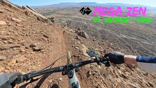
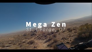
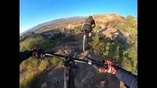
Mega Zen is an optional finish to the traditional Zen. It is a bit more extreme, with some steep rock rolls, some cliffside exposure, and a steep wooden ramp off the bluff. It connects to the Jeep road below the Powerline which can be used to return to the bottom of Zen (Zen Parking Lot) to the north. Recommended for experts only.

Local Trail Association
Traditionally Indigenous Territory

Recent Activity on Trail

Past Week
  • 0 rides
  •  
6 Months
  • 25 rides
  • 10 miles avg distance
All
  • 120 rides
  • Last: Jun 6, 2026
c1c2c3c4
January
February
March
April
May
June
July
August
September
October
November
December
update trails status or condition

Mega Zen Trail Reports

statusdatedescription
May 24, 2026 @ 7:39pm (America/Denver)
May 24, 2026
Oct 20, 2025 @ 12:33pm (America/Denver)
Oct 20, 2025
Apr 29, 2025 @ 2:51pm
Apr 29, 2025
Trail is in good shape. Definitely watch out for one particular tight section on the trail. Exposure and penalty for falling is significant.
Jan 25, 2025 @ 11:26am
Jan 25, 2025
Great shape!
Sep 23, 2024 @ 1:11pm
Sep 23, 2024
Booby trap? Two large nails in the middle of the trail not long before the ramp. Couldn't pull them out by hand.
more »
Status:
on May 24, 2026
Avg: 4.31 (13 votes)
Your vote: 0

view (854)
close
3D
Trail Conditions
  • Unknown
  • Snow Groomed
  • Snow Packed
  • Snow Covered
  • Snow Cover Partial
  • Freeze/thaw Cycle
  • Icy
  • Prevalent Mud
  • Wet
  • Variable
  • Ideal
  • Dry
  • Very Dry
Trail Flow (Ridden Direction)
Trailforks scans users ridelogs to determine the most popular direction each trail is ridden. A good flowing trail network will have most trails flowing in a single direction according to their intension.
The colour categories are based on what percentage of riders are riding a trail in its intended direction.
  • > 96%
  • > 90%
  • > 80%
  • > 70%
  • > 50%
  • < 50%
  • bi-directional trail
  • no data
Trail Last Ridden
Trailforks scans ridelogs to determine the last time a trail was ridden.
  • < 2 days
  • < 1 week
  • < 2 weeks
  • < 1 month
  • < 6 months
  • > 6 months
Trail Ridden Direction
The intended direction a trail should be ridden.
  • Downhill Only
  • Downhill Primary
  • Both Directions
  • Uphill Primary
  • Uphill Only
  • One Direction
Contribute Details
Colors indicate trail is missing specified detail.
  • Description
  • Photos
  • Description & Photos
  • Videos
Trail Popularity ?
Trailforks scans ridelogs to determine which trails are ridden the most in the last 9 months. Trails are compared with nearby trails in the same city region with a possible 25 colour shades. Think of this as a heatmap, more rides = more kinetic energy = warmer colors.
  • most popular
  • popular
  • less popular
  • not popular
ATV/ORV/OHV Filter
Max Vehicle Width
inches
US Cell Coverage
Legend
cell carrier legend

Radar Time
Activity Recordings
Trailforks uses anonymized public activity data. ?
Activity Recordings
Trailforks uses anonymized public activity data. ?
Personal Heatmap
Activity Types
all / none
Options
2
Date range month
Winter Trails
Warning A routing network for winter maps does not exist. Selecting trails using the winter trails layer has been disabled.
Missing Trails
Most Popular
Least Popular
Trails are colored based on popularity. The more popular a trail is, the more red. Less popular trails trend towards green.
Jump Magnitude Heatmap
Heatmap of where riders jump on trails. Zoom in to see individual jumps, click circles to view jump details.
BC Backroad Status

Service Road Atlas is a free to use, community-driven service for viewing and creating reports on the numerous back-country service roads around B.C. and Alberta.

map legend
Slope Aspect
Direction the slope faces
Flat N NE E SE S SW W NW
Trails Deemphasized
Trails are shown in grey.
disable
Only show trails with no bike usage.
Enable
Suggested Layers
Based on selected activity type

    Save the current map location and zoom level as your default home location whenever this page is loaded.

    Save
        Directions to mega-zen trailhead (37.066980, -113.639580)

        Photos

        16 more »
        69 |
        Feb 25, 2026 @ 11:56am
        Feb 25, 2026
        448 |
        Jan 3, 2023 @ 2:23am
        Jan 3, 2023
        437 |
        Jan 3, 2023 @ 2:23am
        Jan 3, 2023
        433 |
        Jan 3, 2023 @ 2:23am
        Jan 3, 2023

        Videos

        5 more »
        youtuber The MEGA ZEN to Mario World! | Mountain Biking...
        19:07 | 659 | Apr 15, 2023 , St. George
        Mega Zen - St. George
        9:36 | 170 | Apr 6, 2025 , St. George
        Mega Zen - Double Black - St George, UT
        8:15 | 139 | Mar 23, 2025 , St. George
        Good times on Mega Zen #zen #mtb #bike...
        11:02 | 133 | Jun 4, 2024 , St. George

        Routes with this trail

        16 miles 2,443 ft 16
        favorite route in green valley

        14 Reviews & Comments


        We hope you've been enjoying Trailforks!

        Create a FREE account to view trail comments and much more.

        • By jkwilliamzTF Pro TRAILFORKS & contributors
        • #587107 - 4,289 views

        Frequently Asked Questions About Mega Zen

        Where is Mega Zen located?
        Mega Zen is located in St. George, Utah, United States. It is part of the St. George trail network. The trailhead is located at coordinates 37.06698, -113.63958.
        How hard is Mega Zen?
        Mega Zen is rated as Double Black Diamond difficulty. The physical rating is Hard. The average grade is 6.8%. The climb difficulty is rated Double Black Diamond.
        What is the elevation gain for Mega Zen?
        Mega Zen has 33 ft of elevation gain. The trail has 298 ft of elevation descent. The elevation ranges from 3,050 ft to 3,314 ft.
        How long is Mega Zen?
        Mega Zen is 3,911 ft long. The trail type is singletrack.

        Hit the Trail

        Open in App

        Get this trail on your phone instantly.
        open trail in app

        Download Trail

        Save to wishlist, Garmin & download.
        save the trail

        Find Related Routes

        Find routes and users activities that include this trail.
        find routes for this trail

        You must enter a description before submitting.