3,305 ft
Distance
26 ft
Climb
-295 ft
Descent
00:07:20
Avg time
Supporters, Builders, Maintainers & Land Managers of Mohawk Trail
- Sponsor
Mohawk Details
-
Activities
- Mountain Bike
-
Riding AreaGalbraith
Bellingham, Washington -
Difficulty Rating
-
Voted DifficultyBlack Diamond (5 votes)
-
Trail TypeMachine Groomed
-
Bike TypeDH, AM
-
DirectionDownhill OnlyPopular direction shown
-
Physical RatingModerate
-
Dogs AllowedYes
-
eBike Allowed
-
TTFs on TrailBerm, Jump, Gap Jump, Roller Coaster
-
Global Ranking#297 in Mountain Biking
-
Local Popularity95 in Mountain Biking
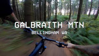
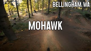
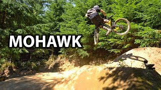
Mohawk is a fresh WMBC build in July of 2018 featuring numerous gap jumps, hip jumps and other goodness.
* Props to Spencer Baldwin & Andy Grant for this trail design and build & Bill Hawk for the the vision *
Disclaimer
Take it easy on the first lap, get to know the trail first then rip!
Local Trail Association
-
Please consider joining or donating to the local trail association to supportdonate to earn trail karma!
trail development & maintenance.
Traditionally Indigenous Territory
More Stats for Mohawk mountain bike trail trail
-
Altitude change-269 ft
-
Altitude min1,484 ft
-
Altitude max1,766 ft
-
Altitude start1,753 ft
-
Altitude end1,484 ft
-
Grade-8.141%
-
Grade max-27.941%
-
Grade min19.832%
-
Distance climb342 ft
-
Distance down2,583 ft
-
Distance flat380 ft
-
Avg time00:07:20
-
Avg reverse time00:17:35
- view trail stats
close
3D
Trail Conditions
- Unknown
- Snow Groomed
- Snow Packed
- Snow Covered
- Snow Cover Inadequate
- Freeze/thaw Cycle
- Icy
- Prevalent Mud
- Wet
- Variable
- Ideal
- Dry
- Very Dry
Trail Flow (Ridden Direction)
Trailforks scans users ridelogs to determine the most popular direction each trail is ridden. A good flowing trail network will have most trails flowing in a single direction according to their intension.
The colour categories are based on what percentage of riders are riding a trail in its intended direction.
- > 96%
- > 90%
- > 80%
- > 70%
- > 50%
- < 50%
- bi-directional trail
- no data
Trail Last Ridden
Trailforks scans ridelogs to determine the last time a trail was ridden.
- < 2 days
- < 1 week
- < 2 weeks
- < 1 month
- < 6 months
- > 6 months
Trail Ridden Direction
The intended direction a trail should be ridden.
- Downhill Only
- Downhill Primary
- Both Directions
- Uphill Primary
- Uphill Only
- One Direction
Contribute Details
Colors indicate trail is missing specified detail.
- Description
- Photos
- Description & Photos
- Videos
Trail Popularity ?
Trailforks scans ridelogs to determine which trails are ridden the most in the last 9 months.
Trails are compared with nearby trails in the same city region with a possible 25 colour shades.
Think of this as a heatmap, more rides = more kinetic energy = warmer colors.
- most popular
- popular
- less popular
- not popular
ATV/ORV/OHV Filter
Max Vehicle Width
inches
Radar Time
x
Activity Recordings
Trailforks users anonymized public ridelogs from the past 6 months.
- mountain biking recent
- mountain biking (>6 month)
- hiking (1 year)
- moto (1 year)
Activity Recordings
Trailforks users anonymized public skilogs from the past 12 months.
- Downhill Ski
- Backcountry Ski
- Nordic Ski
- Snowmobile
Winter Trails
Warning
A routing network for winter maps does not exist. Selecting trails using the winter trails layer has been disabled.
x
Missing Trails
Most Popular
Least Popular
Trails are colored based on popularity. The more popular a trail is, the more red. Less popular trails trend towards green.
Jump Magnitude Heatmap
Heatmap of where riders jump on trails. Zoom in to see individual jumps, click circles to view jump details.
Trails Deemphasized
Trails are shown in grey.
Only show trails with NO bikes.
Save the current map location and zoom level as your default home location whenever this page is loaded.
Save
Directions to mohawk trailhead
(48.709810, -122.391930)
update trails status or condition
Mohawk Trail Reports
view all reports »
Recent Ridelog Activity on Trail
Past Week
- 79 rides
- 14 miles avg distance
6 Months
- 848 rides
- 13 miles avg distance
All
- 10,963 rides
- Last: Jun 9, 2023
Photos
more »
Routes with this trail
more »
Trail Products
14 Reviews & Comments
We hope you've been enjoying Trailforks!
Create a FREE account to view trail comments and much more.
Videos
more »
Nearby Trails
- Tower Trail 325 ft
- Evolution 518 ft
- Evolution Alt 623 ft
- Dad Bod 696 ft
- Wraparound 735 ft
- embed Mohawk trail on your website
- By dsellinger
& contributors
- #133926 - 14,283 views
- subscribe
- login to download gpx or kml files.