more stats
1,158 ft
Distance
62 ft
Climb
-49 ft
Descent
00:03:50
Avg time
13 ft
Altitude change
933 ft
Altitude min
981 ft
Altitude max
933 ft
Altitude start
945 ft
Altitude end
1.1%
Grade
-16.5%
Grade max
26.5%
Grade min
591 ft
Distance climb
449 ft
Distance down
118 ft
Distance flat
00:03:50
Avg time

Murse Made Details

  • Activities
    • Mountain Bike
    • E-Bike
    • Hike
    • Trail Running
  • Riding Area
    One Mile Lake
    Pemberton, British Columbia
  • Difficulty Rating
  • Local Popularity
    95 in Mountain Biking heatmap [+]
    • 85 in E-Biking
    • 95 in Trail Running
    • 85 in Hiking
  • Global Ranking
    #79608 in Mountain Biking [+]
    • #116372 in E-Biking
    • #90684 in Trail Running
    • #111709 in Hiking
  • Provincial Ranking
    #3,917 in Mountain Biking · British Columbia [+]
    • #5,610 in E-Biking
    • #5,245 in Trail Running
    • #6,007 in Hiking
  • Trail Type
    Singletrack
  • Direction
    Uphill Primary
    Popular Direction Shown
  • Dogs Allowed
    Yes
  • eBike Allowed
    Yes up to Class 1

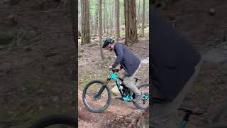
Part of the One Mile frontside climbing network of trails. Couple of moderately challenging rock steps and an excellent optional, really fun, log ride.

Access Info

Just after finishing Piece of Cake and climbing the initial hill of One Mile Nairn, turn left at the large, week marked sign

Tags
SkinniesStairs

Local Trail Association

Traditionally Indigenous Territory

Recent Activity on Trail

Past Week
  • 1 rides
  • 2 miles average
6 Months
  • 94 rides
  • 7 miles avg distance
All
  • 1,096 rides
  • Last: Nov 15, 2026
update trails status or condition

Murse Made Trail Reports

statusdatedescription
Oct 2, 2026 @ 2:14pm (America/Vancouver)
Oct 2, 2026
Aug 14, 2026 @ 6:08pm (America/Vancouver)
Aug 14, 2026
reporter
Jul 16, 2026 @ 2:45pm (America/Vancouver)
Jul 16, 2026
CLOSED FOR WILDFIRE, please stay away and allow our saviors to work!
Jul 16, 2026 @ 2:42pm (America/Vancouver)
Jul 16, 2026
CLOSED FOR WILDFIRE, please stay away and allow our saviors to work!
Feb 16, 2026 @ 2:12pm (America/Vancouver)
Feb 16, 2026
Damp and slippery, but ok
more »
Status:
on Oct 2, 2026
Variable
Avg: 3.79 (4 votes)
Your vote: 0

view (9,268)
close
      Directions to murse-made trailhead (50.305630, -122.806080)

      Photos

      7 more »
      report
      mtb
      54 |
      Sep 5, 2023 @ 5:43pm
      Sep 5, 2023
      report
      mtb
      37 |
      Aug 29, 2023 @ 6:08pm
      Aug 29, 2023
      report
      mtb
      72 |
      Jul 20, 2020 @ 1:09pm
      Jul 20, 2020
      report
      mtb
      80 |
      Apr 19, 2019 @ 1:43pm
      Apr 19, 2019

      Videos

      1 more »
      youtuber Why Doesn't Every Climb Trail Have These?...
      mtb
      0:58 | 151 | Mar 29, 2024 , Pemberton

      Routes with this trail

      more »
      17 miles • 3,809 ft • 19 •
      Get Ready for PORCA’s big day out, the latest iteration of a long-running tradition of big, gruelling...
      30 miles • 7,219 ft • 32 •
      Get Ready for PORCA’s big day out, the latest iteration of a long-running tradition of big, gruelling...
      3 miles • 861 ft • 6 •
      This week’s Fiver heads to the Mackenzie zone for the fall fiver return. Course: Pioneer, Fizzy Pop,...

      Trail Products

      3.5 ★★★★★
      4 Ratings
      5 ★ 50%
      4 ★
      3 ★ 25%
      2 ★
      1 ★ 25%

      1 Review & Comments

      Sun2306 Sun2306
      A nice climbing trail that skips a nasty part on Overhill.

      We hope you've been enjoying Trailforks!

      Create a FREE account to view all trail reviews and much more.

      • By StoneGod PVTA & contributors
      • #58781 - 1,790 views

      Frequently Asked Questions

      ▼ Where is Murse Made located?
      Murse Made is located in One Mile Lake, Pemberton, British Columbia, Canada. It is part of the One Mile Lake trail network. The trailhead is located at coordinates 50.30563, -122.80608.
      ▼ How hard is Murse Made?
      Murse Made is rated as Blue difficulty. The average grade is 1.1%.
      ▼ What is the elevation gain for Murse Made?
      Murse Made has 62 ft of elevation gain. The trail has 49 ft of elevation descent. The elevation ranges from 933 ft to 981 ft.
      ▼ Is Murse Made a point to point trail?
      Murse Made is not a point to point trail. The direction is Uphill Primary. The trail type is singletrack.
      ▼ How long is Murse Made?
      Murse Made is 1,158 ft long. The trail type is singletrack.
      ▼ Are dogs allowed on Murse Made?
      Yes, dogs are allowed on Murse Made. Please keep dogs on a leash where required and clean up after them.
      ▼ How do I access Murse Made? Where is the closest parking trailhead?
      The closest parking and trailhead locations to Murse Made are: View all parking locations in the area.
      ▼ How long does it take to ride Murse Made?
      Based on recorded activities, it takes an average of 4 minutes to ride Murse Made. The trail is 1,158 ft long. Actual times will vary based on fitness level, conditions, and pace. View recent activity logs for more details.
      ▼ How busy is Murse Made?
      Murse Made is a very popular trail. There have been 8,504 recorded activities on this trail. The trail has received 9,268 check-ins. View recent activity on this trail.

      Hit the Trail

      Open in App

      Get this trail on your phone instantly.

      open trail in app

      Download Trail

      Save to wishlist, Garmin & download.
      save the trail

      Find Related Routes

      Find routes and users activities that include this trail.
      find routes for this trail

      You must enter a description before submitting.