more stats
2,028 ft
Distance
21 ft
Climb
-66 ft
Descent
00:08:35
Avg time
-48 ft
Altitude change
1,371 ft
Altitude min
1,428 ft
Altitude max
1,418 ft
Altitude start
1,371 ft
Altitude end
-2.3%
Grade
-18.5%
Grade max
14.6%
Grade min
302 ft
Distance climb
830 ft
Distance down
896 ft
Distance flat
00:08:35
Avg time

OFN Details

  • Activities
    • Mountain Bike
    • E-Bike
    • Hike
    • Trail Running
  • Riding Area
    Doumont
    Nanaimo, British Columbia
  • Difficulty Rating
  • Local Popularity
    65 in Mountain Biking [+]
    • 75 in E-Biking
    • 70 in Trail Running
    • 55 in Hiking
  • Global Ranking
    #85630 in Mountain Biking [+]
    • #49670 in E-Biking
    • #83189 in Trail Running
    • #115107 in Hiking
  • Hiking SAC Scale
    T1 Hiking
  • Trail Type
    Singletrack
  • Bike Type
    AM, XC
  • Direction
    One Direction
    Popular Direction Shown
  • Climb Difficulty
    Black Diamond
  • Physical Rating
    Hard
  • Trail Visibility
    Sometimes hard to follow
  • Dogs Allowed
    Yes
  • eBike Allowed
    Yes up to Class 1
  • TTFs on Trail
    Rock Face, Skinny
  • Year Opened
    2020

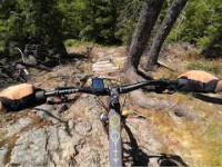
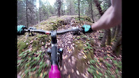
The last segment of trail to access ASOP from Ho Chi Minh Trail . OFN (Oh F@#k No) adds another short punchy climb to beautiful views of Mount Benson, Blackjack Ridge and beyond. A huge rock slab line, long low skinny and short lumpy downhill gets you to where you need to go.
OFN also connect to a spur road of Branch 142 which takes you around the backside of Mount Benson.

This trail is unsanctioned.

Disclaimer

Please stay on the trail, let's keep the moss on the rocks.

Traditionally Indigenous Territory

Recent Activity on Trail

Past Week
  • 1 rides
  • 7 miles average
6 Months
  • 31 rides
  • 9 miles avg distance
All
  • 444 rides
  • Last: Jun 28, 2026
c1c2c3c4
January
February
March
April
May
June
July
August
September
October
November
December
update trails status or condition

OFN Trail Reports

statusdatedescription
May 18, 2026 @ 10:42am (America/Vancouver)
May 18, 2026
Some sections of the trail are getting overgrown otherwise good.
Jan 10, 2026 @ 3:57pm (America/Vancouver)
Jan 10, 2026
Removed a few trees. Trail is clear end to end.
Jul 14, 2025 @ 12:59pm
Jul 14, 2025
hand cleared after the rock roll to ASOP, still could use a hedgetrim but sightlines have been improved
Jun 23, 2025 @ 7:58pm
Jun 23, 2025
cut back some overgrowth in first section but it is getting bushy in a lot of spots, especially after the rock roll.
Apr 5, 2025 @ 10:35am
Apr 5, 2025
more »
Status:
on May 18, 2026
Dry
Avg: 3.82 (11 votes)
Your vote: 0

view (1,842)
close
3D
Trail Conditions
  • Unknown
  • Snow Groomed
  • Snow Packed
  • Snow Covered
  • Snow Cover Partial
  • Freeze/thaw Cycle
  • Icy
  • Prevalent Mud
  • Wet
  • Variable
  • Ideal
  • Dry
  • Very Dry
Trail Flow (Ridden Direction)
Trailforks scans users ridelogs to determine the most popular direction each trail is ridden. A good flowing trail network will have most trails flowing in a single direction according to their intension.
The colour categories are based on what percentage of riders are riding a trail in its intended direction.
  • > 96%
  • > 90%
  • > 80%
  • > 70%
  • > 50%
  • < 50%
  • bi-directional trail
  • no data
Trail Last Ridden
Trailforks scans ridelogs to determine the last time a trail was ridden.
  • < 2 days
  • < 1 week
  • < 2 weeks
  • < 1 month
  • < 6 months
  • > 6 months
Trail Ridden Direction
The intended direction a trail should be ridden.
  • Downhill Only
  • Downhill Primary
  • Both Directions
  • Uphill Primary
  • Uphill Only
  • One Direction
Contribute Details
Colors indicate trail is missing specified detail.
  • Description
  • Photos
  • Description & Photos
  • Videos
Trail Popularity ?
Trailforks scans ridelogs to determine which trails are ridden the most in the last 9 months. Trails are compared with nearby trails in the same city region with a possible 25 colour shades. Think of this as a heatmap, more rides = more kinetic energy = warmer colors.
  • most popular
  • popular
  • less popular
  • not popular
ATV/ORV/OHV Filter
Max Vehicle Width
inches
US Cell Coverage
Legend
cell carrier legend

Radar Time
Activity Recordings
Trailforks uses anonymized public activity data. ?
Activity Recordings
Trailforks uses anonymized public activity data. ?
Personal Heatmap
Activity Types
all / none
Options
2
Date range month
Winter Trails
Warning A routing network for winter maps does not exist. Selecting trails using the winter trails layer has been disabled.
Missing Trails
Most Popular
Least Popular
Trails are colored based on popularity. The more popular a trail is, the more red. Less popular trails trend towards green.
Jump Magnitude Heatmap
Heatmap of where riders jump on trails. Zoom in to see individual jumps, click circles to view jump details.
BC Backroad Status

Service Road Atlas is a free to use, community-driven service for viewing and creating reports on the numerous back-country service roads around B.C. and Alberta.

map legend
Slope Aspect
Direction the slope faces
Flat N NE E SE S SW W NW
Trails Deemphasized
Trails are shown in grey.
disable
Only show trails with no bike usage.
Enable
Suggested Layers
Based on selected activity type

    Save the current map location and zoom level as your default home location whenever this page is loaded.

    Save
        Directions to ofn trailhead (49.184480, -124.106900)

        Photos

        11 more »
        74 |
        Jun 25, 2023 @ 6:52am
        Jun 25, 2023
        107 |
        Jun 15, 2023 @ 6:58am
        Jun 15, 2023
        101 |
        Jun 15, 2023 @ 6:56am
        Jun 15, 2023
        113 |
        Sep 10, 2022 @ 6:08pm
        Sep 10, 2022

        Videos

        2 more »
        OFN / ASOP / Bee Line | Doumont | Nanaimo, BC
        69 | Jun 15, 2025 , Nanaimo
        ofn to asop
        4:30 | 398 | Jul 16, 2020 , Nanaimo

        Routes with this trail

        123 miles 18,870 ft 510 Loop Race
        This event route is a fundraiser for Nanaimo Loaves and Fishes. Robin Dutton and Peter Sinclair will see...

        3 Reviews & Comments


        We hope you've been enjoying Trailforks!

        Create a FREE account to view trail comments and much more.

        Nearby Trails

        • #273325 - 1,897 views

        Frequently Asked Questions About OFN

        Where is OFN located?
        OFN is located in Doumont, Nanaimo, British Columbia, Canada. It is part of the Doumont trail network. The trailhead is located at coordinates 49.18448, -124.1069.
        How hard is OFN?
        OFN is rated as Black Diamond difficulty. The physical rating is Hard. The average grade is 2.3%. The climb difficulty is rated Black Diamond.
        What is the elevation gain for OFN?
        OFN has 21 ft of elevation gain. The trail has 66 ft of elevation descent. The elevation ranges from 1,371 ft to 1,428 ft.
        Is OFN a point to point trail?
        Yes, OFN is a point to point trail. The direction is One Direction. The trail type is singletrack.

        Hit the Trail

        Open in App

        Get this trail on your phone instantly.
        open trail in app

        Download Trail

        Save to wishlist, Garmin & download.
        save the trail

        Find Related Routes

        Find routes and users activities that include this trail.
        find routes for this trail

        You must enter a description before submitting.