more stats
2,723 ft
Distance
31 ft
Climb
-224 ft
Descent
00:04:40
Avg time
-193 ft
Altitude change
1,115 ft
Altitude min
1,340 ft
Altitude max
1,308 ft
Altitude start
1,115 ft
Altitude end
-7.1%
Grade
-35.9%
Grade max
15%
Grade min
551 ft
Distance climb
2,096 ft
Distance down
75 ft
Distance flat
00:04:40
Avg time

Old Exit Details

  • Activities
    • Mountain Bike
    • E-Bike
  • Riding Area
  • Difficulty Rating
  • Voted Difficulty
    Advanced (1 vote)
  • Local Popularity
    65 in Mountain Biking [+]
    • 75 in E-Biking
  • Global Ranking
    #31136 in Mountain Biking [+]
    • #32053 in E-Biking
  • Trail Type
    Singletrack
  • Bike Type
    AM, XC
  • Direction
    Downhill Primary
    Popular Direction Shown
  • Physical Rating
    Moderate
  • eBike Allowed
    Yes up to Class 1

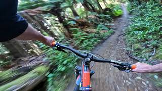
Starts from Tokorangi Pa Rd close to the intersection of Nursery Rd with a short climb in (gun it as it is pretty much the last one of the day, if you are exiting on Long Mile Rd) then a quick short downhill.
Cross the forest road into a very short cutting with a jump at the end (and a good optional nana berm). Whip back across the road and into the main part of the trail with some great fast downhill sections.
Nice rolling jumps and berms make this an excellent finish for those heading out to Long Mile Rd.
A blast - but, careful but - there are some tricky bits to kill yourself on if you are snoozing, especially if you have been out riding for four hours.
About two-thirds of the way down the trail splits. The original trail - on the right - is still quite technical with some braking ruts, most of the way down it. Still a 3.
The left hand option is for more skilled riders with this big drop off, on the left - hold your speed Grade 4.

Normally handles wet weather, well, if not too many riding it on their brakes.

source: Ride Rotorua
Local Trail Association

Recent Activity on Trail

Past Week
  • 0 rides
  •  
6 Months
  • 96 rides
  • 24.2 km avg distance
All
  • 633 rides
  • Last: Jun 29, 2026
c1c2c3c4
January
February
March
April
May
June
July
August
September
October
November
December
update trails status or condition

Old Exit Trail Reports

statusdatedescription
Jun 24, 2026 @ 12:21pm (Pacific/Auckland)
Jun 23, 2026
Took the leafblower out for a walk this morning. Full trail cleared.
Jun 3, 2026 @ 3:23pm (Pacific/Auckland)
Jun 2, 2026
Tree down has been removed
May 12, 2026 @ 4:03pm (Pacific/Auckland)
May 11, 2026
Fixed some rutted sections in the top half this morning
Apr 20, 2026 @ 2:33pm (Pacific/Auckland)
Apr 19, 2026
The first 20m of downhill received a major overhaul this morning
Apr 13, 2026 @ 12:24pm (Pacific/Auckland)
Apr 12, 2026
Cleared, and fixed some sections after the rain we had yesterday. The infamous log drop at the very end had a bit of a tickle up as well.
more »
Status:
on Jun 24, 2026
Variable
Avg: 4.42 (15 votes)
Your vote: 0

view (5,010)
close
3D
Trail Conditions
  • Unknown
  • Snow Groomed
  • Snow Packed
  • Snow Covered
  • Snow Cover Partial
  • Freeze/thaw Cycle
  • Icy
  • Prevalent Mud
  • Wet
  • Variable
  • Ideal
  • Dry
  • Very Dry
Trail Flow (Ridden Direction)
Trailforks scans users ridelogs to determine the most popular direction each trail is ridden. A good flowing trail network will have most trails flowing in a single direction according to their intension.
The colour categories are based on what percentage of riders are riding a trail in its intended direction.
  • > 96%
  • > 90%
  • > 80%
  • > 70%
  • > 50%
  • < 50%
  • bi-directional trail
  • no data
Trail Last Ridden
Trailforks scans ridelogs to determine the last time a trail was ridden.
  • < 2 days
  • < 1 week
  • < 2 weeks
  • < 1 month
  • < 6 months
  • > 6 months
Trail Ridden Direction
The intended direction a trail should be ridden.
  • Downhill Only
  • Downhill Primary
  • Both Directions
  • Uphill Primary
  • Uphill Only
  • One Direction
Contribute Details
Colors indicate trail is missing specified detail.
  • Description
  • Photos
  • Description & Photos
  • Videos
Trail Popularity ?
Trailforks scans ridelogs to determine which trails are ridden the most in the last 9 months. Trails are compared with nearby trails in the same city region with a possible 25 colour shades. Think of this as a heatmap, more rides = more kinetic energy = warmer colors.
  • most popular
  • popular
  • less popular
  • not popular
ATV/ORV/OHV Filter
Max Vehicle Width
inches
US Cell Coverage
Legend
cell carrier legend

Radar Time
Activity Recordings
Trailforks uses anonymized public activity data. ?
Activity Recordings
Trailforks uses anonymized public activity data. ?
Personal Heatmap
Activity Types
all / none
Options
2
Date range month
Winter Trails
Warning A routing network for winter maps does not exist. Selecting trails using the winter trails layer has been disabled.
Missing Trails
Most Popular
Least Popular
Trails are colored based on popularity. The more popular a trail is, the more red. Less popular trails trend towards green.
Jump Magnitude Heatmap
Heatmap of where riders jump on trails. Zoom in to see individual jumps, click circles to view jump details.
BC Backroad Status

Service Road Atlas is a free to use, community-driven service for viewing and creating reports on the numerous back-country service roads around B.C. and Alberta.

map legend
Slope Aspect
Direction the slope faces
Flat N NE E SE S SW W NW
Trails Deemphasized
Trails are shown in grey.
disable
Only show trails with no bike usage.
Enable
Suggested Layers
Based on selected activity type

    Save the current map location and zoom level as your default home location whenever this page is loaded.

    Save
        Directions to old-exit trailhead (-38.165320, 176.269950)

        Photos

        48 more »
        829 |
        Mar 23, 2017 @ 3:06am
        Mar 23, 2017
        675 |
        Mar 23, 2017 @ 3:06am
        Mar 23, 2017
        78 |
        Oct 28, 2022 @ 3:07am
        Oct 28, 2022
        67 |
        Jun 26, 2017 @ 2:45am
        Jun 26, 2017

        Videos

        16 more »
        youtuber Old Exit @ Whakarewarewa Forest. Rotorua
        3:11 | 135 | Nov 4, 2024 , Rotorua
        youtuber Tuko...no...hi...Tukonohi... Might be hard to...
        7:12 | 152 | Mar 27, 2021 , Rotorua
        youtuber Old Exit - old school  fun
        3:49 | 159 | Apr 5, 2021 , Rotorua
        youtuber Old Exit - Old School Grade 4 - Rotorua MTB
        3:36 | 212 | Jun 9, 2021 , Rotorua

        Routes with this trail

        32 miles 4,577 ft 31
        51km of everything that makes Rotorua world-famous for mountain biking. From steaming geothermal valleys...
        3.0 16 miles 2,978 ft 37 Loop
        This is another great loop that the locals enjoy. Expect a fun day in the saddle while you ride some of...
        26 miles 3,654 ft 52
        The classic old school MTB one lap race will not change however the addition of timed enduro segments...

        2 Reviews & Comments


        We hope you've been enjoying Trailforks!

        Create a FREE account to view trail comments and much more.

        • By mbl77TF Pro PCBC & contributors
        • #18022 - 5,715 views

        Frequently Asked Questions About Old Exit

        Where is Old Exit located?
        Old Exit is located in Whakarewarewa Forest, Rotorua, New Zealand. It is part of the Whakarewarewa Forest trail network. The trailhead is located at coordinates -38.16532, 176.26995.
        How hard is Old Exit?
        Old Exit is rated as Advanced difficulty. The physical rating is Moderate. The average grade is 7.1%.
        What is the elevation gain for Old Exit?
        Old Exit has 10 m of elevation gain. The trail has 68 m of elevation descent. The elevation ranges from 340 m to 408 m.
        Is Old Exit a point to point trail?
        Old Exit is not a point to point trail. The direction is Downhill Primary. The trail type is singletrack.

        Hit the Trail

        Open in App

        Get this trail on your phone instantly.
        open trail in app

        Download Trail

        Save to wishlist, Garmin & download.
        save the trail

        Find Related Routes

        Find routes and users activities that include this trail.
        find routes for this trail

        You must enter a description before submitting.