more stats
4,295 ft
Distance
77 ft
Climb
-740 ft
Descent
00:09:56
Avg time
-663 ft
Altitude change
1,641 ft
Altitude min
2,312 ft
Altitude max
2,312 ft
Altitude start
1,650 ft
Altitude end
-15.5%
Grade
-54.1%
Grade max
30%
Grade min
659 ft
Distance climb
3,333 ft
Distance down
302 ft
Distance flat
00:09:56
Avg time

Ponstan Details

  • Activities
    • Mountain Bike
    • E-Bike
  • Riding Area
  • Difficulty Rating
  • Voted Difficulty
    Black Diamond (7 votes)
  • Local Popularity
    100 in Mountain Biking [+]
    • 95 in E-Biking
  • Global Ranking
    #29150 in Mountain Biking [+]
    • #5603 in E-Biking
  • Trail Type
    Singletrack
  • Bike Type
    DH, AM
  • Direction
    Downhill Only
    Popular Direction Shown
  • Physical Rating
    Hard
  • Trail Visibility
    Always easy to follow
  • eBike Allowed
    Yes up to Class 1
  • TTFs on Trail
    Berm, Drop, Jump, Gap Jump, Rock Garden

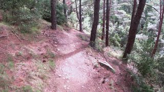
One of the best Immitos has to offer. This trail is not for the faint of heart, as it boasts a challenging terrain and technical features. But for those who are up for the challenge, this trail is sure to provide an experience
Starting off the trail opens up into fast-flowing singletrack that lets you really let loose and pick up some speed. But don't get too comfortable, as the technical features and obstacles continue to challenge you all the way down. From switch backs and gap jumps, there's always something new and exciting around every turn.

Local Trail Association

Recent Activity on Trail

Past Week
  • 3 rides
  • 11 miles average
6 Months
  • 26 rides
  • 12 miles avg distance
All
  • 189 rides
  • Last: Jul 1, 2026
c1c2c3c4
January
February
March
April
May
June
July
August
September
October
November
December
update trails status or condition

Ponstan Trail Reports

statusdatedescription
Feb 23, 2026 @ 11:37pm (Europe/Athens)
Feb 23, 2026
Feb 22, 2026 @ 7:03am (Europe/Athens)
Feb 21, 2026
Jul 21, 2025 @ 7:39am
Jul 21, 2025
Apr 3, 2025 @ 5:04am
Apr 3, 2025
the trail is a bit wet on the lower section and the rocks and roots are quite slippery. I suggest bring really careful on the rocky sections
Mar 8, 2025 @ 10:29am
Mar 8, 2025
more »
Status:
on Feb 23, 2026
Avg: 4.52 (14 votes)
Your vote: 0

view (2,032)
close
3D
Trail Conditions
  • Unknown
  • Snow Groomed
  • Snow Packed
  • Snow Covered
  • Snow Cover Partial
  • Freeze/thaw Cycle
  • Icy
  • Prevalent Mud
  • Wet
  • Variable
  • Ideal
  • Dry
  • Very Dry
Trail Flow (Ridden Direction)
Trailforks scans users ridelogs to determine the most popular direction each trail is ridden. A good flowing trail network will have most trails flowing in a single direction according to their intension.
The colour categories are based on what percentage of riders are riding a trail in its intended direction.
  • > 96%
  • > 90%
  • > 80%
  • > 70%
  • > 50%
  • < 50%
  • bi-directional trail
  • no data
Trail Last Ridden
Trailforks scans ridelogs to determine the last time a trail was ridden.
  • < 2 days
  • < 1 week
  • < 2 weeks
  • < 1 month
  • < 6 months
  • > 6 months
Trail Ridden Direction
The intended direction a trail should be ridden.
  • Downhill Only
  • Downhill Primary
  • Both Directions
  • Uphill Primary
  • Uphill Only
  • One Direction
Contribute Details
Colors indicate trail is missing specified detail.
  • Description
  • Photos
  • Description & Photos
  • Videos
Trail Popularity ?
Trailforks scans ridelogs to determine which trails are ridden the most in the last 9 months. Trails are compared with nearby trails in the same city region with a possible 25 colour shades. Think of this as a heatmap, more rides = more kinetic energy = warmer colors.
  • most popular
  • popular
  • less popular
  • not popular
ATV/ORV/OHV Filter
Max Vehicle Width
inches
US Cell Coverage
Legend
cell carrier legend

Radar Time
Activity Recordings
Trailforks uses anonymized public activity data. ?
Activity Recordings
Trailforks uses anonymized public activity data. ?
Personal Heatmap
Activity Types
all / none
Options
2
Date range month
Winter Trails
Warning A routing network for winter maps does not exist. Selecting trails using the winter trails layer has been disabled.
Missing Trails
Most Popular
Least Popular
Trails are colored based on popularity. The more popular a trail is, the more red. Less popular trails trend towards green.
Jump Magnitude Heatmap
Heatmap of where riders jump on trails. Zoom in to see individual jumps, click circles to view jump details.
BC Backroad Status

Service Road Atlas is a free to use, community-driven service for viewing and creating reports on the numerous back-country service roads around B.C. and Alberta.

map legend
Slope Aspect
Direction the slope faces
Flat N NE E SE S SW W NW
Trails Deemphasized
Trails are shown in grey.
disable
Only show trails with no bike usage.
Enable
Suggested Layers
Based on selected activity type

    Save the current map location and zoom level as your default home location whenever this page is loaded.

    Save
        Directions to ponstan trailhead (37.966560, 23.815490)

        Photos

        2 more »
        145 |
        Oct 3, 2021 @ 9:42am
        Oct 3, 2021
        252 |
        Dec 28, 2020 @ 11:50pm
        Dec 28, 2020

        Videos

        3 more »
        Immito - Ponstan Followcam
        3:17 | 476 | May 13, 2024 , Athens
        Ponstan trail  with a crash Υμηττός
        12:43 | 502 | Feb 8, 2022 , Athens
        PONSTAN-FRIENDLY RIDE
        2:55 | 211 | Oct 5, 2021 , Athens

        1 Review & Comments


        We hope you've been enjoying Trailforks!

        Create a FREE account to view trail comments and much more.

        • By ancaironTF Pro & contributors
        • #233121 - 4,976 views

        Frequently Asked Questions About Ponstan

        Where is Ponstan located?
        Ponstan is located in Imittos Mountain, Athens, Greece. It is part of the Imittos Mountain trail network. The trailhead is located at coordinates 37.96656, 23.81549.
        How hard is Ponstan?
        Ponstan is rated as Black Diamond difficulty. The physical rating is Hard. The average grade is 15.5%.
        What is the elevation gain for Ponstan?
        Ponstan has 77 ft of elevation gain. The trail has 740 ft of elevation descent. The elevation ranges from 1,641 ft to 2,312 ft.
        Is Ponstan a point to point trail?
        Yes, Ponstan is a point to point trail. The direction is Downhill Only. The trail type is singletrack.

        Hit the Trail

        Open in App

        Get this trail on your phone instantly.
        open trail in app

        Download Trail

        Save to wishlist, Garmin & download.
        save the trail

        Find Related Routes

        Find routes and users activities that include this trail.
        find routes for this trail

        You must enter a description before submitting.