more stats
1.1 miles
Distance
49 ft
Climb
-808 ft
Descent
00:14:22
Avg time
-759 ft
Altitude change
1,804 ft
Altitude min
2,613 ft
Altitude max
2,612 ft
Altitude start
1,854 ft
Altitude end
-13.7%
Grade
-109.1%
Grade max
11.8%
Grade min
1,014 ft
Distance climb
4,439 ft
Distance down
105 ft
Distance flat
00:14:22
Avg time

PT (Upper) Details

  • Activities
    • Mountain Bike
  • Riding Area
    Raging River State Forest
    Snoqualmie, Washington
  • AKA
    Physical Therapy
  • Difficulty Rating
  • Voted Difficulty
    Black Diamond (5 votes)
  • Local Popularity
    80 in Mountain Biking
  • Global Ranking
    #35604 in Mountain Biking
  • Trail Type
    Singletrack
  • Bike Type
    DH, AM
  • Direction
    Downhill Only
    Popular Direction Shown
  • Physical Rating
    Hard
  • Trail Visibility
    Always easy to follow
  • Dogs Allowed
    Yes
  • eBike Allowed
  • TTFs on Trail
    Drop
  • Land Owner

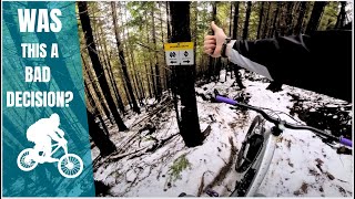
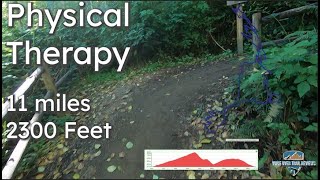
Upper PT (or Physical Therapy) is a steep and technical descending only trail. After the road crossing, stay right -- taking a left puts you on Reverence. Stay right again at the next intersection to stay on the single black diamond route (Dr. Phil) or go left for the original double black diamond route.

From the bottom you can climb out using the Raging Tiger trail which connects with Upward Mobility. You can also take Raging Tiger down to connect to PT (Middle) and continue the Physical Therapy journey.

Disclaimer

PT not recommended in wet weather (slick soil when wet)

Local Trail Association
Traditionally Indigenous Territory

Recent Activity on Trail

Past Week
  • 1 rides
  • 13 miles average
6 Months
  • 44 rides
  • 12 miles avg distance
All
  • 665 rides
  • Last: Jun 27, 2026
c1c2c3c4
January
February
March
April
May
June
July
August
September
October
November
December
update trails status or condition

PT (Upper) Trail Reports

statusdatedescription
May 12, 2026 @ 2:17pm (America/Los_Angeles)
May 12, 2026
Apr 6, 2026 @ 10:49pm (America/Los_Angeles)
Apr 6, 2026
About as good as it gets. Lots of trail work by Evergreen over the weekend. Thanks!
Mar 28, 2026 @ 9:46pm (America/Los_Angeles)
Mar 28, 2026
Tree down at about the mid point in the flatter sections. The entire trail tread needs a sweep/ rake.
May 28, 2025 @ 8:39am
May 28, 2025
May 28, 2025 @ 8:39am
May 28, 2025
more »
Status:
on May 12, 2026
Dry
Avg: 4.26 (24 votes)
Your vote: 0

view (3,903)
close
3D
Trail Conditions
  • Unknown
  • Snow Groomed
  • Snow Packed
  • Snow Covered
  • Snow Cover Partial
  • Freeze/thaw Cycle
  • Icy
  • Prevalent Mud
  • Wet
  • Variable
  • Ideal
  • Dry
  • Very Dry
Trail Flow (Ridden Direction)
Trailforks scans users ridelogs to determine the most popular direction each trail is ridden. A good flowing trail network will have most trails flowing in a single direction according to their intension.
The colour categories are based on what percentage of riders are riding a trail in its intended direction.
  • > 96%
  • > 90%
  • > 80%
  • > 70%
  • > 50%
  • < 50%
  • bi-directional trail
  • no data
Trail Last Ridden
Trailforks scans ridelogs to determine the last time a trail was ridden.
  • < 2 days
  • < 1 week
  • < 2 weeks
  • < 1 month
  • < 6 months
  • > 6 months
Trail Ridden Direction
The intended direction a trail should be ridden.
  • Downhill Only
  • Downhill Primary
  • Both Directions
  • Uphill Primary
  • Uphill Only
  • One Direction
Contribute Details
Colors indicate trail is missing specified detail.
  • Description
  • Photos
  • Description & Photos
  • Videos
Trail Popularity ?
Trailforks scans ridelogs to determine which trails are ridden the most in the last 9 months. Trails are compared with nearby trails in the same city region with a possible 25 colour shades. Think of this as a heatmap, more rides = more kinetic energy = warmer colors.
  • most popular
  • popular
  • less popular
  • not popular
ATV/ORV/OHV Filter
Max Vehicle Width
inches
US Cell Coverage
Legend
cell carrier legend

Radar Time
Activity Recordings
Trailforks uses anonymized public activity data. ?
Activity Recordings
Trailforks uses anonymized public activity data. ?
Personal Heatmap
Activity Types
all / none
Options
2
Date range month
Winter Trails
Warning A routing network for winter maps does not exist. Selecting trails using the winter trails layer has been disabled.
Missing Trails
Most Popular
Least Popular
Trails are colored based on popularity. The more popular a trail is, the more red. Less popular trails trend towards green.
Jump Magnitude Heatmap
Heatmap of where riders jump on trails. Zoom in to see individual jumps, click circles to view jump details.
BC Backroad Status

Service Road Atlas is a free to use, community-driven service for viewing and creating reports on the numerous back-country service roads around B.C. and Alberta.

map legend
Slope Aspect
Direction the slope faces
Flat N NE E SE S SW W NW
Trails Deemphasized
Trails are shown in grey.
disable
Only show trails with no bike usage.
Enable
Suggested Layers
Based on selected activity type

    Save the current map location and zoom level as your default home location whenever this page is loaded.

    Save
        Directions to pt-upper trailhead (47.485840, -121.830680)

        Photos

        25 more »
        228 |
        Sep 8, 2023 @ 6:44am
        Sep 8, 2023
        166 |
        Jan 18, 2023 @ 9:05pm
        Jan 18, 2023
        183 |
        Jan 18, 2023 @ 9:05pm
        Jan 18, 2023
        166 |
        Jan 18, 2023 @ 9:05pm
        Jan 18, 2023

        Videos

        12 more »
        youtuber Physical Therapy - Raging River Full POV...
        16:57 | 349 | May 5, 2023 , Snoqualmie
        youtuber Physical Therapy
        7:19 | 1836 | Aug 11, 2020 , Snoqualmie
        youtuber Osborne Mountain and Teeley Creek
        18:04 | 585 | Aug 7, 2020 , Snoqualmie
        youtuber Raging River Guide || A Destination Trail System!
        32:19 | 112 | Nov 11, 2024 , Snoqualmie

        Routes with this trail

        PT8
        3.0 11 miles 1,776 ft 4 Loop
        PT Figure 8 from Hwy 18. Park in the gravel lot off of Hwy 18 and head up Rattlesnake Mtn Rd until you get...
        38 miles 8,226 ft 12 Loop
        This used to be a 'TriFecta' with No Service, CCDH and PT, but now with the addition of Reverence it's now...
        70 miles 12,856 ft 36
        The Real McCoy loop 2024 edition. Now with Tokyo Drift!

        6 Reviews & Comments


        We hope you've been enjoying Trailforks!

        Create a FREE account to view trail comments and much more.

        Frequently Asked Questions About PT (Upper)

        Where is PT (Upper) located?
        PT (Upper) is located in Raging River State Forest, Snoqualmie, Washington, United States. It is part of the Raging River State Forest trail network. The trailhead is located at coordinates 47.48584, -121.83068.
        How hard is PT (Upper)?
        PT (Upper) is rated as Black Diamond difficulty. The physical rating is Hard. The average grade is 13.7%.
        What is the elevation gain for PT (Upper)?
        PT (Upper) has 49 ft of elevation gain. The trail has 808 ft of elevation descent. The elevation ranges from 1,804 ft to 2,613 ft.
        Is PT (Upper) a point to point trail?
        Yes, PT (Upper) is a point to point trail. The direction is Downhill Only. The trail type is singletrack.

        Hit the Trail

        Open in App

        Get this trail on your phone instantly.
        open trail in app

        Download Trail

        Save to wishlist, Garmin & download.
        save the trail

        Find Related Routes

        Find routes and users activities that include this trail.
        find routes for this trail

        You must enter a description before submitting.