more stats
1.9 miles
Distance
-1,200 ft
Descent
2,538 ft
High Point
-1,200 ft
Altitude change
1,339 ft
Altitude min
2,538 ft
Altitude start
1,339 ft
Altitude end
-11.8%
Grade
-50%
Grade max
0.8%
Grade min
43 ft
Distance climb
2 miles
Distance down
128 ft
Distance flat

Reverence Details

  • Activities
    • Mountain Bike
  • Riding Area
    Raging River State Forest
    Snoqualmie, Washington
  • Difficulty Rating
  • Voted Difficulty
    Black Diamond (4 votes)
  • Local Popularity
    90 in Mountain Biking
  • Global Ranking
    #739 in Mountain Biking
  • Trail Type
    Singletrack
  • Direction
    Downhill Only
    Popular Direction Shown
  • Dogs Allowed
    Yes
  • eBike Allowed
  • TTFs on Trail
    Drop, Jump
  • Land Owner
    Department of Natural Resources

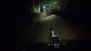
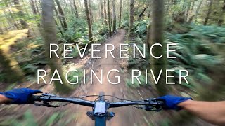
New Raging Phase 3 downhill trail opening June 8, 2024. Formerly known as PCDH, Reverence is a volunteer powered mostly natural hand-built singletrack downhill trail with tons of roots, rocks & gnar, and a short machine-built flow section. It's on the easier side of black diamond trails at Raging and Tiger. The goal is to let it gnarl up over time and end up somewhere between CCDH and Upper Physical Therapy. If you've mastered CCDH, this is your next challenge.
Reverence is a volunteer powered project that our riding community can really be proud of. Over 120 different volunteers checked in to >110 work parties and logged >2,200 hours of labor. And that's just digging time. If you add drive time to/from home, getting up/down the mountain to the trailhead, hiking in to the worksite and all the time associated with planning, organization, purchasing, tool management, etc, our guess is well over 3,000 total volunteer hours. Gargantuan thank you and epic reverence to Dave the leader and all the volunteers and staff involved

Local Trail Association
Traditionally Indigenous Territory

Recent Activity on Trail

Past Week
  • 10 rides
  • 13 miles average
6 Months
  • 150 rides
  • 14 miles avg distance
All
  • 765 rides
  • Last: Jun 18, 2026
c1c2c3c4
January
February
March
April
May
June
July
August
September
October
November
December
update trails status or condition

Reverence Trail Reports

statusdatedescription
May 17, 2026 @ 2:38pm (America/Los_Angeles)
May 17, 2026
Lots of big puddles. Ridable but a little sketchy
Apr 6, 2026 @ 10:50pm (America/Los_Angeles)
Apr 6, 2026
About as good as it gets. Lots of trail work by Evergreen over the weekend. Thanks!
Apr 3, 2026 @ 3:37pm (America/Los_Angeles)
Apr 3, 2026
intermittent standing puddles and two small trees you can ride right over
Mar 21, 2026 @ 11:00am (America/Los_Angeles)
Mar 21, 2026
Small tree down across trail, can navigate over or around
Mar 21, 2026 @ 10:42am (America/Los_Angeles)
Mar 21, 2026
Small tree down across trail, can navigate over or around
more »
Status:
on May 17, 2026
Wet
Avg: 4.67 (24 votes)
Your vote: 0

view (3,581)
close
3D
Trail Conditions
  • Unknown
  • Snow Groomed
  • Snow Packed
  • Snow Covered
  • Snow Cover Partial
  • Freeze/thaw Cycle
  • Icy
  • Prevalent Mud
  • Wet
  • Variable
  • Ideal
  • Dry
  • Very Dry
Trail Flow (Ridden Direction)
Trailforks scans users ridelogs to determine the most popular direction each trail is ridden. A good flowing trail network will have most trails flowing in a single direction according to their intension.
The colour categories are based on what percentage of riders are riding a trail in its intended direction.
  • > 96%
  • > 90%
  • > 80%
  • > 70%
  • > 50%
  • < 50%
  • bi-directional trail
  • no data
Trail Last Ridden
Trailforks scans ridelogs to determine the last time a trail was ridden.
  • < 2 days
  • < 1 week
  • < 2 weeks
  • < 1 month
  • < 6 months
  • > 6 months
Trail Ridden Direction
The intended direction a trail should be ridden.
  • Downhill Only
  • Downhill Primary
  • Both Directions
  • Uphill Primary
  • Uphill Only
  • One Direction
Contribute Details
Colors indicate trail is missing specified detail.
  • Description
  • Photos
  • Description & Photos
  • Videos
Trail Popularity ?
Trailforks scans ridelogs to determine which trails are ridden the most in the last 9 months. Trails are compared with nearby trails in the same city region with a possible 25 colour shades. Think of this as a heatmap, more rides = more kinetic energy = warmer colors.
  • most popular
  • popular
  • less popular
  • not popular
ATV/ORV/OHV Filter
Max Vehicle Width
inches
US Cell Coverage
Legend
cell carrier legend

Radar Time
Activity Recordings
Trailforks uses anonymized public activity data. ?
Activity Recordings
Trailforks uses anonymized public activity data. ?
Personal Heatmap
Activity Types
all / none
Options
2
Date range month
Winter Trails
Warning A routing network for winter maps does not exist. Selecting trails using the winter trails layer has been disabled.
Missing Trails
Most Popular
Least Popular
Trails are colored based on popularity. The more popular a trail is, the more red. Less popular trails trend towards green.
Jump Magnitude Heatmap
Heatmap of where riders jump on trails. Zoom in to see individual jumps, click circles to view jump details.
BC Backroad Status

Service Road Atlas is a free to use, community-driven service for viewing and creating reports on the numerous back-country service roads around B.C. and Alberta.

map legend
Slope Aspect
Direction the slope faces
Flat N NE E SE S SW W NW
Trails Deemphasized
Trails are shown in grey.
disable
Only show trails with no bike usage.
Enable
Suggested Layers
Based on selected activity type

    Save the current map location and zoom level as your default home location whenever this page is loaded.

    Save
        Directions to reverence trailhead (47.485600, -121.832300)

        Photos

        9 more »
        80 |
        Jul 18, 2025 @ 7:15am
        Jul 18, 2025
        95 |
        Jul 18, 2025 @ 7:15am
        Jul 18, 2025
        184 |
        Sep 30, 2024 @ 9:59pm
        Sep 30, 2024
        217 |
        Sep 30, 2024 @ 9:58pm
        Sep 30, 2024

        Videos

        13 more »
        youtuber Reverence at Raging River || Raw Upload Night Ride
        11:23 | 172 | May 16, 2025 , Snoqualmie
        youtuber My new favorite trail here!
        11:19 | 643 | Jul 22, 2024 , Snoqualmie
        youtuber Raging River's Best Wet Lap Trails | Full Send
        4:57 | 57 | Dec 8, 2025 , Snoqualmie
        Reverence - Raging River - North Bend,...
        11:04 | 215 | Aug 15, 2025 , Snoqualmie

        Routes with this trail

        5.0 10 miles 1,864 ft 6 Loop
        TL;DR;: It's , but skips the last 300 vertical feet. This means you need to stop after the fifth segment,...
        6 miles 607 ft 6
        Festival Shuttle Drop #2, down and back up on , then down Pop Tops to Flow State and back to the festival
        9 miles 745 ft 5 Point to Point
        From the festival shuttle drop #2 ( and ) -> down -> back up Raging-Tiger -> to Lower Poppin Tops...

        12 Reviews & Comments


        We hope you've been enjoying Trailforks!

        Create a FREE account to view trail comments and much more.

        • By I5-TrollTF Pro EMBA-Staff & contributors
        • #761168 - 6,889 views

        Frequently Asked Questions About Reverence

        Where is Reverence located?
        Reverence is located in Raging River State Forest, Snoqualmie, Washington, United States. It is part of the Raging River State Forest trail network. The trailhead is located at coordinates 47.4856, -121.8323.
        How hard is Reverence?
        Reverence is rated as Black Diamond difficulty. The average grade is 11.8%.
        What is the elevation gain for Reverence?
        The trail has 1,200 ft of elevation descent. The elevation ranges from 1,339 ft to 2,538 ft.
        Is Reverence a point to point trail?
        Yes, Reverence is a point to point trail. The direction is Downhill Only. The trail type is singletrack.

        Hit the Trail

        Open in App

        Get this trail on your phone instantly.
        open trail in app

        Download Trail

        Save to wishlist, Garmin & download.
        save the trail

        Find Related Routes

        Find routes and users activities that include this trail.
        find routes for this trail

        You must enter a description before submitting.