more stats
2.3 miles
Distance
260 ft
Climb
-910 ft
Descent
00:16:26
Avg time
-650 ft
Altitude change
1,300 ft
Altitude min
1,953 ft
Altitude max
1,950 ft
Altitude start
1,299 ft
Altitude end
-5.3%
Grade
-56.7%
Grade max
32.7%
Grade min
2,956 ft
Distance climb
2 miles
Distance down
1,184 ft
Distance flat
00:16:26
Avg time

Roller Coasters Details

  • Activities
    • Mountain Bike
    • E-Bike
    • Gravel Bike
    • Adaptive Bike
    • Hike
    • Trail Running
  • Riding Area
    Cuesta Ridge West
    San Luis Obispo, California
  • Difficulty Rating
  • Voted Difficulty
    Green (1 vote)
  • Local Popularity
    70 in Mountain Biking [+]
    • 65 in E-Biking
    • 60 in Trail Running
    • 5 in Hiking
  • Trail Type
    Doubletrack
  • Bike Type
    AM, XC, Adaptive MTB, CX, Gravel
  • Direction
    Both Directions
  • Season
    Year Round
  • Dogs Allowed
    Yes
  • eBike Allowed
    Yes up to Class 1
  • Land Owner
    USFS

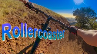
The Roller Coasters Trail is an undulating path that begins atop the West Cuesta Grade and follows the wavy ridge to the Union Pacific Railroad Tracks.

Trail Supporters

  • USFS
    Land Manager
Traditionally Indigenous Territory

Recent Activity on Trail

Past Week
  • 0 rides
  •  
6 Months
  • 9 rides
  • 16 miles avg distance
All
  • 51 rides
  • Last: Jun 18, 2026
c1c2c3c4
January
February
March
April
May
June
July
August
September
October
November
December
update trails status or condition

Roller Coasters Trail Reports

statusdatedescription
Jan 2, 2026 @ 11:03am (America/Los_Angeles)
Jan 2, 2026
Nov 24, 2025 @ 8:39am (America/Los_Angeles)
Nov 24, 2025
Oct 16, 2025 @ 2:21pm (America/Los_Angeles)
Oct 16, 2025
The trail is better after the rain. Not so loose from the recent grading. Wind was really bad today, though. 20+ mph gusts.
Mar 29, 2025 @ 7:00pm
Mar 29, 2025
Nov 30, 2024 @ 7:07pm
Nov 30, 2024
more »
Status:
on Jan 2, 2026
Variable
Avg: 3.36 (5 votes)
Your vote: 0

view (479)
close
3D
Trail Conditions
  • Unknown
  • Snow Groomed
  • Snow Packed
  • Snow Covered
  • Snow Cover Partial
  • Freeze/thaw Cycle
  • Icy
  • Prevalent Mud
  • Wet
  • Variable
  • Ideal
  • Dry
  • Very Dry
Trail Flow (Ridden Direction)
Trailforks scans users ridelogs to determine the most popular direction each trail is ridden. A good flowing trail network will have most trails flowing in a single direction according to their intension.
The colour categories are based on what percentage of riders are riding a trail in its intended direction.
  • > 96%
  • > 90%
  • > 80%
  • > 70%
  • > 50%
  • < 50%
  • bi-directional trail
  • no data
Trail Last Ridden
Trailforks scans ridelogs to determine the last time a trail was ridden.
  • < 2 days
  • < 1 week
  • < 2 weeks
  • < 1 month
  • < 6 months
  • > 6 months
Trail Ridden Direction
The intended direction a trail should be ridden.
  • Downhill Only
  • Downhill Primary
  • Both Directions
  • Uphill Primary
  • Uphill Only
  • One Direction
Contribute Details
Colors indicate trail is missing specified detail.
  • Description
  • Photos
  • Description & Photos
  • Videos
Trail Popularity ?
Trailforks scans ridelogs to determine which trails are ridden the most in the last 9 months. Trails are compared with nearby trails in the same city region with a possible 25 colour shades. Think of this as a heatmap, more rides = more kinetic energy = warmer colors.
  • most popular
  • popular
  • less popular
  • not popular
ATV/ORV/OHV Filter
Max Vehicle Width
inches
US Cell Coverage
Legend
cell carrier legend

Radar Time
Activity Recordings
Trailforks uses anonymized public activity data. ?
Activity Recordings
Trailforks uses anonymized public activity data. ?
Personal Heatmap
Activity Types
all / none
Options
2
Date range month
Winter Trails
Warning A routing network for winter maps does not exist. Selecting trails using the winter trails layer has been disabled.
Missing Trails
Most Popular
Least Popular
Trails are colored based on popularity. The more popular a trail is, the more red. Less popular trails trend towards green.
Jump Magnitude Heatmap
Heatmap of where riders jump on trails. Zoom in to see individual jumps, click circles to view jump details.
BC Backroad Status

Service Road Atlas is a free to use, community-driven service for viewing and creating reports on the numerous back-country service roads around B.C. and Alberta.

map legend
Slope Aspect
Direction the slope faces
Flat N NE E SE S SW W NW
Trails Deemphasized
Trails are shown in grey.
disable
Only show trails with no bike usage.
Enable
Suggested Layers
Based on selected activity type

    Save the current map location and zoom level as your default home location whenever this page is loaded.

    Save
        Directions to roller-coasters trailhead (35.345040, -120.640300)

        Photos

        17 more »
        95 |
        Jan 11, 2022 @ 6:53pm
        Jan 11, 2022
        167 |
        Nov 29, 2020 @ 11:11am
        Nov 29, 2020
        110 |
        Jul 17, 2020 @ 8:09pm
        Jul 17, 2020
        109 |
        Jul 17, 2020 @ 8:09pm
        Jul 17, 2020

        Videos

        2 more »
        New Flow Trail on West Cuesta Ridge!!!...
        10:22 | 288 | Jan 17, 2022 , San Luis Obispo
        Leaving 2020 Behind Riding Rollercoaster...
        12:21 | 389 | Jan 1, 2021 , San Luis Obispo

        Routes with this trail

        4.0 27 miles 4,716 ft 49 Shuttled
        The near Ultimate Point to Point Shuttle route that covers all the major trail on the Ridge except for...
        3.4 24 miles 3,219 ft 15 Loop
        Starting in downtown SLO (Pepper Street has unlimited parking free) and heading North on Monterey, you...
        3.0 8 miles 1,699 ft 5 Loop
        A fun loop ride with a good downhill from the parking area at Cuesta Pass.

        Links

        6 Reviews & Comments


        We hope you've been enjoying Trailforks!

        Create a FREE account to view trail comments and much more.

        • By aoneal & contributors
        • #30061 - 4,965 views

        Frequently Asked Questions About Roller Coasters

        Where is Roller Coasters located?
        Roller Coasters is located in Cuesta Ridge West, San Luis Obispo, California, United States. It is part of the Cuesta Ridge West trail network. The trailhead is located at coordinates 35.34504, -120.6403.
        What is the elevation gain for Roller Coasters?
        Roller Coasters has 260 ft of elevation gain. The trail has 910 ft of elevation descent. The elevation ranges from 1,300 ft to 1,953 ft.
        Is Roller Coasters a point to point trail?
        Roller Coasters is not a point to point trail. The direction is Both Directions. The trail type is doubletrack.
        How long is Roller Coasters?
        Roller Coasters is 2.3 miles long. The trail type is doubletrack.

        Hit the Trail

        Open in App

        Get this trail on your phone instantly.
        open trail in app

        Download Trail

        Save to wishlist, Garmin & download.
        save the trail

        Find Related Routes

        Find routes and users activities that include this trail.
        find routes for this trail

        You must enter a description before submitting.