more stats
1.8 miles
Distance
526 ft
Climb
-349 ft
Descent
00:30:48
Avg time
177 ft
Altitude change
2,158 ft
Altitude min
2,676 ft
Altitude max
2,162 ft
Altitude start
2,339 ft
Altitude end
1.8%
Grade
-49.2%
Grade max
41.3%
Grade min
5,128 ft
Distance climb
3,727 ft
Distance down
804 ft
Distance flat
00:30:48
Avg time

Rusty Chainsaw Details

  • Activities
    • Mountain Bike
    • E-Bike
    • Hike
    • Trail Running
  • Riding Area
    Trail Bluffs
    Trail, British Columbia
  • Difficulty Rating
  • Local Popularity
    60 in Mountain Biking [+]
    • 40 in E-Biking
    • 30 in Trail Running
    • 50 in Hiking
  • Global Ranking
    #95218 in Mountain Biking [+]
    • #80520 in E-Biking
    • #125620 in Trail Running
    • #107137 in Hiking
  • Trail Type
    Singletrack
  • Bike Type
    AM, XC
  • Direction
    One Direction
    Popular Direction Shown
  • Climb Difficulty
    Black Diamond
  • Physical Rating
    Hard
  • Season
    February to November
  • Dogs Allowed
    Yes
  • eBike Allowed
    Yes up to Class 1
  • TTFs on Trail
    Ladder Bridge, Rock Face, Rock Garden
  • Ride in Rain
    Yes
  • Year Opened
    2016
  • Land Owner
    Kootenay Columbia Trails Society

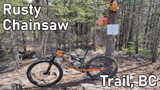
Completed during summer 2016 by the KCTS, the Rusty Chainsaw trail adds slightly more challenging cross-country riding to the Bluffs trail network. Lots of elaborate trail construction, technical crux moves and incredible views.Ride in a counter clockwise direction.

Local Trail Association

Recent Activity on Trail

Past Week
  • 2 rides
  • 18.1 km average
6 Months
  • 23 rides
  • 12.7 km avg distance
All
  • 120 rides
  • Last: Jul 1, 2026
c1c2c3c4
January
February
March
April
May
June
July
August
September
October
November
December
update trails status or condition

Rusty Chainsaw Trail Reports

statusdatedescription
Jul 1, 2026 @ 11:35am (America/Creston)
1 day
Very overgrown and tree down on the ride down.
Jun 1, 2026 @ 5:22pm (America/Vancouver)
Jun 1, 2026
Cleared trail of downed trees yesterday. Starting to get a bit overgrown with vegetation.
May 15, 2026 @ 10:46am (America/Vancouver)
May 15, 2026
Apr 24, 2026 @ 8:45am (America/Vancouver)
Apr 24, 2026
reporter The KCTS trail crew completed seasonal inspection and maintenance.
Mar 11, 2026 @ 9:15am (America/Vancouver)
Mar 11, 2026
reporter The Sunningdale trail will be closed on Monday March 16th (and possibly Tuesday March 17th) as a contractor removes identified hazard trees....
more »
Status:
on Jul 1, 2026
Variable
Avg: 4.22 (7 votes)
Your vote: 0

view (1,059)
close
3D
Trail Conditions
  • Unknown
  • Snow Groomed
  • Snow Packed
  • Snow Covered
  • Snow Cover Partial
  • Freeze/thaw Cycle
  • Icy
  • Prevalent Mud
  • Wet
  • Variable
  • Ideal
  • Dry
  • Very Dry
Trail Flow (Ridden Direction)
Trailforks scans users ridelogs to determine the most popular direction each trail is ridden. A good flowing trail network will have most trails flowing in a single direction according to their intension.
The colour categories are based on what percentage of riders are riding a trail in its intended direction.
  • > 96%
  • > 90%
  • > 80%
  • > 70%
  • > 50%
  • < 50%
  • bi-directional trail
  • no data
Trail Last Ridden
Trailforks scans ridelogs to determine the last time a trail was ridden.
  • < 2 days
  • < 1 week
  • < 2 weeks
  • < 1 month
  • < 6 months
  • > 6 months
Trail Ridden Direction
The intended direction a trail should be ridden.
  • Downhill Only
  • Downhill Primary
  • Both Directions
  • Uphill Primary
  • Uphill Only
  • One Direction
Contribute Details
Colors indicate trail is missing specified detail.
  • Description
  • Photos
  • Description & Photos
  • Videos
Trail Popularity ?
Trailforks scans ridelogs to determine which trails are ridden the most in the last 9 months. Trails are compared with nearby trails in the same city region with a possible 25 colour shades. Think of this as a heatmap, more rides = more kinetic energy = warmer colors.
  • most popular
  • popular
  • less popular
  • not popular
ATV/ORV/OHV Filter
Max Vehicle Width
inches
US Cell Coverage
Legend
cell carrier legend

Radar Time
Activity Recordings
Trailforks uses anonymized public activity data. ?
Activity Recordings
Trailforks uses anonymized public activity data. ?
Personal Heatmap
Activity Types
all / none
Options
2
Date range month
Winter Trails
Warning A routing network for winter maps does not exist. Selecting trails using the winter trails layer has been disabled.
Missing Trails
Most Popular
Least Popular
Trails are colored based on popularity. The more popular a trail is, the more red. Less popular trails trend towards green.
Jump Magnitude Heatmap
Heatmap of where riders jump on trails. Zoom in to see individual jumps, click circles to view jump details.
BC Backroad Status

Service Road Atlas is a free to use, community-driven service for viewing and creating reports on the numerous back-country service roads around B.C. and Alberta.

map legend
Slope Aspect
Direction the slope faces
Flat N NE E SE S SW W NW
Trails Deemphasized
Trails are shown in grey.
disable
Only show trails with no bike usage.
Enable
Suggested Layers
Based on selected activity type

    Save the current map location and zoom level as your default home location whenever this page is loaded.

    Save
        Directions to rusty-chainsaw trailhead (49.112720, -117.701520)

        Photos

        8 more »
        646 |
        Oct 17, 2016 @ 1:09pm
        Oct 17, 2016
        585 |
        Oct 17, 2016 @ 1:09pm
        Oct 17, 2016
        651 |
        Oct 17, 2016 @ 1:08pm
        Oct 17, 2016
        552 |
        Oct 17, 2016 @ 1:07pm
        Oct 17, 2016

        Videos

        2 more »
        youtuber Sunningdale - Trail, BC
        7:40 | 704 | Apr 23, 2021 , Trail
        youtuber Rusty Chainsaw - Trail, BC
        6:32 | 733 | Apr 13, 2021 , Trail

        2 Reviews & Comments


        We hope you've been enjoying Trailforks!

        Create a FREE account to view trail comments and much more.

        • By stewspoonerTF Pro KCTS & contributors
        • #71463 - 8,254 views

        Frequently Asked Questions About Rusty Chainsaw

        Where is Rusty Chainsaw located?
        Rusty Chainsaw is located in Trail Bluffs, Trail, British Columbia, Canada. It is part of the Trail Bluffs trail network. The trailhead is located at coordinates 49.11272, -117.70152.
        How hard is Rusty Chainsaw?
        Rusty Chainsaw is rated as Black Diamond difficulty. The physical rating is Hard. The average grade is 1.8%. The climb difficulty is rated Black Diamond.
        What is the elevation gain for Rusty Chainsaw?
        Rusty Chainsaw has 526 ft of elevation gain. The trail has 349 ft of elevation descent. The elevation ranges from 2,158 ft to 2,676 ft.
        Is Rusty Chainsaw a point to point trail?
        Yes, Rusty Chainsaw is a point to point trail. The direction is One Direction. The trail type is singletrack.

        Hit the Trail

        Open in App

        Get this trail on your phone instantly.
        open trail in app

        Download Trail

        Save to wishlist, Garmin & download.
        save the trail

        Find Related Routes

        Find routes and users activities that include this trail.
        find routes for this trail

        You must enter a description before submitting.