more stats
1.7 miles
Distance
402 ft
Climb
-340 ft
Descent
00:27:07
Avg time
60 ft
Altitude change
2,020 ft
Altitude min
2,400 ft
Altitude max
2,020 ft
Altitude start
2,080 ft
Altitude end
0.7%
Grade
-35.1%
Grade max
33.6%
Grade min
4,472 ft
Distance climb
4,101 ft
Distance down
564 ft
Distance flat
00:27:07
Avg time

Bluffs Loop Details

  • Activities
    • Mountain Bike
    • E-Bike
    • Hike
    • Trail Running
  • Riding Area
    Trail Bluffs
    Trail, British Columbia
  • Difficulty Rating
  • Local Popularity
    100 in Mountain Biking [+]
    • 100 in E-Biking
    • 65 in Trail Running
    • 100 in Hiking
  • Global Ranking
    #38075 in Mountain Biking [+]
    • #5436 in E-Biking
    • #90815 in Trail Running
    • #3053 in Hiking
  • Trail Type
    Singletrack
  • Bike Type
    AM, XC
  • Direction
    One Direction
  • Climb Difficulty
    Blue
  • Physical Rating
    Moderate
  • Dogs Allowed
    Yes
  • eBike Allowed
    Yes up to Class 1
  • OSM Way

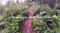
Bluffs Loop is a perfect blue progression trail. Ride it counter clockwise to slowly test your ability level after climbing up Miral Heights. If confident at the Sunnigdale junction complete the loop by riding back down the west side (river side) of Bluffs Loop for a super fun, slightly techie, blue rock ride. Climb back up to the Sunningdale junction and head down for a splendid descent with only a few tight corners while enjoying some stunning visual side hilling. The finale is rewarded with easy sinuous flow. Ride Bluffs Loop clockwise as a warm up to the black diamond Rusty Chainsaw. Take a dip at Gyro Park in the Columbia River for a refreshing cool down.

Local Trail Association

Recent Activity on Trail

Past Week
  • 8 rides
  • 5 miles average
6 Months
  • 165 rides
  • 9 miles avg distance
All
  • 671 rides
  • Last: Jun 30, 2026
c1c2c3c4
January
February
March
April
May
June
July
August
September
October
November
December
update trails status or condition

Bluffs Loop Trail Reports

statusdatedescription
Jun 1, 2026 @ 5:23pm (America/Vancouver)
Jun 1, 2026
Cleared downed trees on May31. Clear to ride now
May 30, 2026 @ 8:31am (America/Vancouver)
May 30, 2026
Several trees down, including three near the top that are challenging to navigate around with a bike and will require a chainsaw to remove
May 15, 2026 @ 10:46am (America/Vancouver)
May 15, 2026
May 12, 2026 @ 1:26pm (America/Vancouver)
May 12, 2026
Tree across the trail just before creek crossing at the northern-most corner, just after Rusty Chainsaw junction.
May 8, 2026 @ 6:16pm (America/Vancouver)
May 8, 2026
more »
Status:
on Jun 1, 2026
Avg: 4.16 (12 votes)
Your vote: 0

view (5,003)
close
3D
Trail Conditions
  • Unknown
  • Snow Groomed
  • Snow Packed
  • Snow Covered
  • Snow Cover Partial
  • Freeze/thaw Cycle
  • Icy
  • Prevalent Mud
  • Wet
  • Variable
  • Ideal
  • Dry
  • Very Dry
Trail Flow (Ridden Direction)
Trailforks scans users ridelogs to determine the most popular direction each trail is ridden. A good flowing trail network will have most trails flowing in a single direction according to their intension.
The colour categories are based on what percentage of riders are riding a trail in its intended direction.
  • > 96%
  • > 90%
  • > 80%
  • > 70%
  • > 50%
  • < 50%
  • bi-directional trail
  • no data
Trail Last Ridden
Trailforks scans ridelogs to determine the last time a trail was ridden.
  • < 2 days
  • < 1 week
  • < 2 weeks
  • < 1 month
  • < 6 months
  • > 6 months
Trail Ridden Direction
The intended direction a trail should be ridden.
  • Downhill Only
  • Downhill Primary
  • Both Directions
  • Uphill Primary
  • Uphill Only
  • One Direction
Contribute Details
Colors indicate trail is missing specified detail.
  • Description
  • Photos
  • Description & Photos
  • Videos
Trail Popularity ?
Trailforks scans ridelogs to determine which trails are ridden the most in the last 9 months. Trails are compared with nearby trails in the same city region with a possible 25 colour shades. Think of this as a heatmap, more rides = more kinetic energy = warmer colors.
  • most popular
  • popular
  • less popular
  • not popular
ATV/ORV/OHV Filter
Max Vehicle Width
inches
US Cell Coverage
Legend
cell carrier legend

Radar Time
Activity Recordings
Trailforks uses anonymized public activity data. ?
Activity Recordings
Trailforks uses anonymized public activity data. ?
Personal Heatmap
Activity Types
all / none
Options
2
Date range month
Winter Trails
Warning A routing network for winter maps does not exist. Selecting trails using the winter trails layer has been disabled.
Missing Trails
Most Popular
Least Popular
Trails are colored based on popularity. The more popular a trail is, the more red. Less popular trails trend towards green.
Jump Magnitude Heatmap
Heatmap of where riders jump on trails. Zoom in to see individual jumps, click circles to view jump details.
BC Backroad Status

Service Road Atlas is a free to use, community-driven service for viewing and creating reports on the numerous back-country service roads around B.C. and Alberta.

map legend
Slope Aspect
Direction the slope faces
Flat N NE E SE S SW W NW
Trails Deemphasized
Trails are shown in grey.
disable
Only show trails with no bike usage.
Enable
Suggested Layers
Based on selected activity type

    Save the current map location and zoom level as your default home location whenever this page is loaded.

    Save
        Directions to bluffs-loop-2136 trailhead (49.110860, -117.699190)

        Photos

        53 more »
        11 |
        May 8, 2026 @ 6:13pm
        May 8, 2026
        14 |
        May 8, 2026 @ 6:13pm
        May 8, 2026
        134 |
        Sep 24, 2021 @ 1:32pm
        Sep 24, 2021
        72 |
        Jul 24, 2021 @ 9:33pm
        Jul 24, 2021

        Videos

        5 more »
        youtuber December Riding in the Kootenays  // The...
        6:56 | 467 | Dec 25, 2020 , Trail
        youtuber Best Mountain Biking in Trail, BC - Bluffs...
        9:49 | 472 | Dec 28, 2020 , Trail
        Exploring Trail
        0:31 | 333 | Jul 3, 2016 , Trail
        Punter is the Man
        3:11 | 267 | Nov 29, 2014 , Trail

        Routes with this trail

        2.7 9 miles 1,499 ft 3 Loop
        Start and finish at Gyro Park for a great loop of the / / trails. NOTE: It is very hot here in the summer....
        5 miles 1,015 ft 3 Point to Point
        Start with a climb up the trail. Do a lap or 2 of the ( usually done counter-clockwise ) and then descend...

        2 Reviews & Comments


        We hope you've been enjoying Trailforks!

        Create a FREE account to view trail comments and much more.

        • By canadakaTF Pro Trailforks & contributors
        • #2136 - 8,550 views

        Frequently Asked Questions About Bluffs Loop

        Where is Bluffs Loop located?
        Bluffs Loop is located in Trail Bluffs, Trail, British Columbia, Canada. It is part of the Trail Bluffs trail network. The trailhead is located at coordinates 49.11086, -117.69919.
        How hard is Bluffs Loop?
        Bluffs Loop is rated as Blue difficulty. The physical rating is Moderate. The average grade is 0.7%. The climb difficulty is rated Blue.
        What is the elevation gain for Bluffs Loop?
        Bluffs Loop has 402 ft of elevation gain. The trail has 340 ft of elevation descent. The elevation ranges from 2,020 ft to 2,400 ft.
        Is Bluffs Loop a point to point trail?
        Yes, Bluffs Loop is a point to point trail. The direction is One Direction. The trail type is singletrack.

        Hit the Trail

        Open in App

        Get this trail on your phone instantly.
        open trail in app

        Download Trail

        Save to wishlist, Garmin & download.
        save the trail

        Find Related Routes

        Find routes and users activities that include this trail.
        find routes for this trail

        You must enter a description before submitting.