1,739 ft
Distance
2 ft
Climb
-108 ft
Descent
00:03:20
Avg time
Supporters, Builders, Maintainers & Land Managers of Schroen Train Trail
Rock Solid Trail ContractingBuilder
Schroen Train Details
-
Activities
- Mountain Bike
- E-Bike
- Hike
- Trail Running
-
Riding AreaSlaughter Pen Trails
Bentonville, Arkansas -
Difficulty Rating
-
Voted DifficultyBlue (1 vote)
-
Trail TypeSingletrack
-
Bike TypeDH, AM, Adaptive MTB
-
DirectionDownhill OnlyPopular direction shown
-
Climb DifficultyBlue
-
Physical RatingModerate
-
Dogs AllowedYes
-
eBike AllowedYes up to Class 1
-
TTFs on TrailBerm, Drop, Jump, Gap Jump, Rock Face
-
Global Ranking
-
Local Popularity70 in Mountain Biking [+]
- 75 in E-Biking
- 50 in Trail Running
- 50 in Hiking
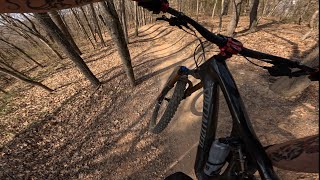
An intermediate level cross country trail that follow the ridge line of Slaughter Pen Phase 2. Updated in 2017, the upper portion of the trail now consists of a flow trail with berms, table top jumps and optional rock jumps. The last section of the trail takes riders down a moderately steep section with a number of rock faces constructed of large slabs.
Adaptive Bike Info
aMTB Green Rating: Beginner features and moderate terrain.
Local Trail Association
-
Please consider joining or donating to the local trail association to supportdonate to earn trail karma!
trail development & maintenance.
Traditionally Indigenous Territory
More Stats for Schroen Train mountain bike trail trail
-
Altitude change-105 ft
-
Altitude min1,127 ft
-
Altitude max1,234 ft
-
Altitude start1,234 ft
-
Altitude end1,129 ft
-
Grade-6.1%
-
Grade max-24.5%
-
Grade min0.4%
-
Distance climb59 ft
-
Distance down1,627 ft
-
Distance flat49 ft
-
Avg time00:03:20
-
Avg reverse time00:08:02
- view trail stats
close
3D
Trail Conditions
- Unknown
- Snow Groomed
- Snow Packed
- Snow Covered
- Snow Cover Partial
- Freeze/thaw Cycle
- Icy
- Prevalent Mud
- Wet
- Variable
- Ideal
- Dry
- Very Dry
Trail Flow (Ridden Direction)
Trailforks scans users ridelogs to determine the most popular direction each trail is ridden. A good flowing trail network will have most trails flowing in a single direction according to their intension.
The colour categories are based on what percentage of riders are riding a trail in its intended direction.
- > 96%
- > 90%
- > 80%
- > 70%
- > 50%
- < 50%
- bi-directional trail
- no data
Trail Last Ridden
Trailforks scans ridelogs to determine the last time a trail was ridden.
- < 2 days
- < 1 week
- < 2 weeks
- < 1 month
- < 6 months
- > 6 months
Trail Ridden Direction
The intended direction a trail should be ridden.
- Downhill Only
- Downhill Primary
- Both Directions
- Uphill Primary
- Uphill Only
- One Direction
Contribute Details
Colors indicate trail is missing specified detail.
- Description
- Photos
- Description & Photos
- Videos
Trail Popularity ?
Trailforks scans ridelogs to determine which trails are ridden the most in the last 9 months.
Trails are compared with nearby trails in the same city region with a possible 25 colour shades.
Think of this as a heatmap, more rides = more kinetic energy = warmer colors.
- most popular
- popular
- less popular
- not popular
ATV/ORV/OHV Filter
Max Vehicle Width
inches
US Cell Coverage
Legend
Radar Time
x
Activity Recordings
Trailforks users anonymized public ridelogs from the past 6 months.
- mountain biking recent
- mountain biking (>6 month)
- hiking (1 year)
- moto (1 year)
Activity Recordings
Trailforks users anonymized public skilogs from the past 12 months.
- Downhill Ski
- Backcountry Ski
- Nordic Ski
- Snowmobile
Winter Trails
Warning
A routing network for winter maps does not exist. Selecting trails using the winter trails layer has been disabled.
x
Missing Trails
Most Popular
Least Popular
Trails are colored based on popularity. The more popular a trail is, the more red. Less popular trails trend towards green.
Jump Magnitude Heatmap
Heatmap of where riders jump on trails. Zoom in to see individual jumps, click circles to view jump details.
Trails Deemphasized
Trails are shown in grey.
Only show trails with NO bikes.
Save the current map location and zoom level as your default home location whenever this page is loaded.
Save
Directions to schroen-train trailhead
(36.393330, -94.201300)
update trails status or condition
Schroen Train Trail Reports
view all reports »
11 social media mentions
Recent Ridelog Activity on Trail
Past Week
- 3 rides
- 11 miles avg distance
6 Months
- 208 rides
- 15 miles avg distance
All
- 1,209 rides
- Last: Jun 19, 2025
Photos
more »
Routes with this trail
more »
7 Reviews & Comments
We hope you've been enjoying Trailforks!
Create a FREE account to view trail comments and much more.
Videos
more »
Nearby Trails
- Schroen Train 0 ft
- Milk Run 154 ft
- 2 Stacks Connector 623 ft
- Sliding Rock 820 ft
- All-american 856 ft
Slaughter Pen Trails
- By WanderingMan
BSMTB & contributors
- #95598 - 7,091 views
- follow/subscribe
- login to download gpx or kml files.
You must enter a description before submitting.