Supporters, Builders, Maintainers & Land Managers of Scogli Rossi Trail
- Sponsor
Scogli Rossi Details
-
Activities
- Mountain Bike
- E-Bike
-
Riding AreaSanremo Bike Resort
Sanremo -
Difficulty Rating
-
Voted DifficultyBlack Diamond (2 votes)
-
Trail TypeSingletrack
-
Bike TypeDH, AM
-
DirectionDownhill OnlyPopular direction shown
-
Physical RatingHard
-
Dogs AllowedYes
-
eBike AllowedYes up to Class 1
-
Global Ranking
-
Local Popularity90 in Mountain Biking [+]
- 40 in E-Biking
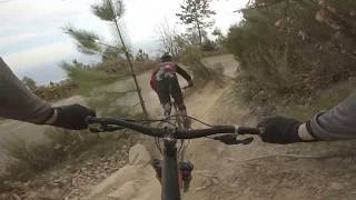
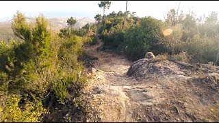
Il percorso di Scogli Rossi è un altro famoso sentiero dedicato a chi ama il gravity, con partenza dalla curva giro bandiera, situata sulla strada provinciale SP56 che collega San Romolo a Bajardo. Questo percorso non vi lascerà un attimo di respiro, caratterizzato da un susseguirsi di sezioni tecniche di roccia fissa, di gradoni naturali e salti, qui il vero discesista può dare libero sfogo alla guida grazie alle numerose linee e salti tecnici che può trovare lungo il perscorso. Questo trail è totalmente esposto al sole, si sviluppa sul crinale della montagna offrendo una vista spettacolare su Sanremo. Termina in località Pian della Castagna.
Bike Park
More Stats for Scogli Rossi mountain bike trail trail
-
Altitude change-1,134 ft
-
Altitude min1,867 ft
-
Altitude max3,001 ft
-
Altitude start3,001 ft
-
Altitude end1,867 ft
-
Grade-22.7%
-
Grade max-82.2%
-
Grade min3.6%
-
Distance climb377 ft
-
Distance down3,907 ft
-
Distance flat686 ft
-
Avg time00:11:15
-
Avg reverse time00:32:23
- view trail stats
-
Layers w
- Map Content
- More Layers
- Pro
- Pro
- Pro
- Pro
- Pro
- Pro
- Pro
- Pro
-
Upgrade to

- Unknown
- Snow Groomed
- Snow Packed
- Snow Covered
- Snow Cover Partial
- Freeze/thaw Cycle
- Icy
- Prevalent Mud
- Wet
- Variable
- Ideal
- Dry
- Very Dry
The colour categories are based on what percentage of riders are riding a trail in its intended direction.
- > 96%
- > 90%
- > 80%
- > 70%
- > 50%
- < 50%
- bi-directional trail
- no data
- < 2 days
- < 1 week
- < 2 weeks
- < 1 month
- < 6 months
- > 6 months
- Downhill Only
- Downhill Primary
- Both Directions
- Uphill Primary
- Uphill Only
- One Direction
- Description
- Photos
- Description & Photos
- Videos
- most popular
- popular
- less popular
- not popular

- mountain biking recent
- mountain biking (>6 month)
- hiking (1 year)
- moto (1 year)
- Downhill Ski
- Backcountry Ski
- Nordic Ski
- Snowmobile
Save the current map location and zoom level as your default home location whenever this page is loaded.
SaveScogli Rossi Trail Reports
Recent Ridelog Activity on Trail
- 0 rides
- 26 rides
- 17.4 km avg distance
- 218 rides
- Last: May 5, 2024
Photos
Routes with this trail
We hope you've been enjoying Trailforks!
Create a FREE account to view trail comments and much more.
Videos

Nearby Trails
- Excalibur 3,054 ft
- Taglio 1 mile
- Borello 1 mile
- La Cisterna 1 mile
- Suri 1 mile
Sanremo Bike Resort
- By denitopia
 TRAILFORKS VTA & contributors
 - #43586 - 4,502 views
- follow/subscribe
- login to download gpx or kml files.
You must enter a description before submitting.