more stats
3,596 ft
Distance
-469 ft
Descent
00:07:24
Avg time
-469 ft
Altitude change
7,002 ft
Altitude min
7,472 ft
Altitude max
7,470 ft
Altitude start
7,001 ft
Altitude end
-13%
Grade
-73%
Grade max
3%
Grade min
43 ft
Distance climb
3,497 ft
Distance down
52 ft
Distance flat
00:07:24
Avg time

Send It Details

  • Activities
    • Mountain Bike
    • Hike
    • Trail Running
  • Riding Area
    Horse Gulch
    Durango, Colorado
  • AKA
    Anasazi
  • Difficulty Rating
  • Local Popularity
    90 in Mountain Biking [+]
    • 55 in Trail Running
    • 45 in Hiking
  • Global Ranking
    #31589 in Mountain Biking [+]
    • #102713 in Trail Running
    • #105765 in Hiking
  • Hiking SAC Scale
    T2 Mountain Hiking
  • Trail Type
    Singletrack
  • Bike Type
    DH, AM, XC
  • Direction
    Downhill Only
    Popular Direction Shown
  • Climb Difficulty
    Double Black Diamond
  • Physical Rating
    Hard
  • Trail Visibility
    Always easy to follow
  • TTFs on Trail
    Berm, Rock Garden, Roller Coaster
  • Land Owner
    City of Durango

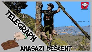
Send It Descent (formally Anasazi) is a technical one-way trail which starts at the top of Telegraph Trail. Although only 0.57-miles, Send It descends 500 feet to meet back up with Meadow Loop. This is an advanced trail, the upper portion is very rocky and technical and is a high-consequence undertaking. Experienced riders will have no issues, beginners should steer clear of this trail or expect to walk a good portion of it.

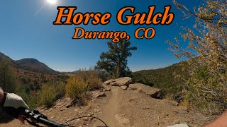
The Horse Gulch Trail System is the perfect trail system for all levels and user types. It accommodates beginners or advanced riders, short rides, long rides, and more. You can start this trail any time of day. It gets dark around 7-8 p.m., depending on the time of year, so you’ll want to be done by then. In summer, these trails are mighty hot so bring plenty of water. Remember, the climb up Horse Gulch Road is the hardest part for beginners, once you arrive at the signed intersection at Meadow trail, you are greeted with 360 degree views and wide open space vistas. This intersection also provides a variety of trail options throughout the system.

History of the area: Daryl Crites, a Durango native, then president of Goff Engineering and longtime Trails 2000 board member, kicked off the preservation of the Horse Gulch area. In the early 1990s, he approached Noel Pautsky, the owner of the vast area east of Durango, about preserving its many trails with permanent easements. Pautsky agreed, and Crites went to work surveying all of the trails, including Crites Connect, Telegraph and Send It Descent. Pautsky eventually gifted the easements to La Plata County. That initial partnership laid the groundwork for a series of recent open space purchases in Horse Gulch by the City of Durango. In addition, Trails 2000 facilitated an easement opening legal access to Raider Ridge in 2009. The acquisitions have promised that the trail network and the pristine high desert surrounding it will be preserved for perpetuity and enjoyed by Durangoans and visitors for generations to come.

source: ...
Local Trail Association
Traditionally Indigenous Territory

Recent Activity on Trail

Past Week
  • 5 rides
  • 14 miles average
6 Months
  • 70 rides
  • 13 miles avg distance
All
  • 501 rides
  • Last: Jun 19, 2026
c1c2c3c4
January
February
March
April
May
June
July
August
September
October
November
December
update trails status or condition

Send It Trail Reports

statusdatedescription
Mar 14, 2026 @ 8:41am (America/Denver)
Mar 14, 2026
reporter
Jan 5, 2026 @ 2:06pm (America/Denver)
Jan 5, 2026
reporter Minimal snow, but prevalent mud if not frozen. Go early to avoid trail damage.
May 8, 2025 @ 12:47pm
May 8, 2025
Apr 7, 2025 @ 11:07am
Apr 7, 2025
reporter
Dec 30, 2024 @ 9:22am
Dec 30, 2024
reporter Snow covered, potential melt out and mud depending on conditions through winter. See https://www.durangotrails.org/winter-trails/ for most up to...
more »
Status:
on Mar 14, 2026
Ideal
Avg: 4.52 (16 votes)
Your vote: 0

view (4,349)
close
3D
Trail Conditions
  • Unknown
  • Snow Groomed
  • Snow Packed
  • Snow Covered
  • Snow Cover Partial
  • Freeze/thaw Cycle
  • Icy
  • Prevalent Mud
  • Wet
  • Variable
  • Ideal
  • Dry
  • Very Dry
Trail Flow (Ridden Direction)
Trailforks scans users ridelogs to determine the most popular direction each trail is ridden. A good flowing trail network will have most trails flowing in a single direction according to their intension.
The colour categories are based on what percentage of riders are riding a trail in its intended direction.
  • > 96%
  • > 90%
  • > 80%
  • > 70%
  • > 50%
  • < 50%
  • bi-directional trail
  • no data
Trail Last Ridden
Trailforks scans ridelogs to determine the last time a trail was ridden.
  • < 2 days
  • < 1 week
  • < 2 weeks
  • < 1 month
  • < 6 months
  • > 6 months
Trail Ridden Direction
The intended direction a trail should be ridden.
  • Downhill Only
  • Downhill Primary
  • Both Directions
  • Uphill Primary
  • Uphill Only
  • One Direction
Contribute Details
Colors indicate trail is missing specified detail.
  • Description
  • Photos
  • Description & Photos
  • Videos
Trail Popularity ?
Trailforks scans ridelogs to determine which trails are ridden the most in the last 9 months. Trails are compared with nearby trails in the same city region with a possible 25 colour shades. Think of this as a heatmap, more rides = more kinetic energy = warmer colors.
  • most popular
  • popular
  • less popular
  • not popular
ATV/ORV/OHV Filter
Max Vehicle Width
inches
US Cell Coverage
Legend
cell carrier legend

Radar Time
Activity Recordings
Trailforks uses anonymized public activity data. ?
Activity Recordings
Trailforks uses anonymized public activity data. ?
Personal Heatmap
Activity Types
all / none
Options
2
Date range month
Winter Trails
Warning A routing network for winter maps does not exist. Selecting trails using the winter trails layer has been disabled.
Missing Trails
Most Popular
Least Popular
Trails are colored based on popularity. The more popular a trail is, the more red. Less popular trails trend towards green.
Jump Magnitude Heatmap
Heatmap of where riders jump on trails. Zoom in to see individual jumps, click circles to view jump details.
BC Backroad Status

Service Road Atlas is a free to use, community-driven service for viewing and creating reports on the numerous back-country service roads around B.C. and Alberta.

map legend
Slope Aspect
Direction the slope faces
Flat N NE E SE S SW W NW
Trails Deemphasized
Trails are shown in grey.
disable
Only show trails with no bike usage.
Enable
Suggested Layers
Based on selected activity type

    Save the current map location and zoom level as your default home location whenever this page is loaded.

    Save
        Directions to send-it-13800 trailhead (37.258970, -107.844960)

        Photos

        3 more »
        138 |
        Oct 18, 2023 @ 12:57pm
        Oct 18, 2023
        151 |
        Oct 18, 2023 @ 12:57pm
        Oct 18, 2023
        280 |
        Jun 13, 2022 @ 11:40am
        Jun 13, 2022

        Videos

        5 more »
        youtuber Single Tracks: Send It (Anasazi) - Horse Gulch...
        5:02 | 415 | Jul 22, 2022 , Durango
        youtuber Best MTB Trails in Durango, CO - Horse Gulch...
        10:40 | 520 | Feb 23, 2024 , Durango
        Telegraph Trails 2011 'Anasazi Descent'
        4:22 | 544 | Apr 27, 2020 , Durango
        Shredding Durrrango!
        12:05 | 405 | Nov 24, 2019 , Durango

        Routes with this trail

        21 miles 3,332 ft 14 Point to Point
        route for advanced riders. Higher mileage ride with good climbs. Flowy downhills also with technical riding.
        21 miles 3,332 ft 21 Point to Point
        route for advanced riders. Higher mileage ride with good climbs. Flowy downhills also with technical riding.
        21 miles 3,332 ft 14 Point to Point
        route for advanced riders. Higher mileage ride with good climbs. Flowy downhills also with technical riding.

        7 Reviews & Comments


        We hope you've been enjoying Trailforks!

        Create a FREE account to view trail comments and much more.

        • By toddTF Pro Trailforks & contributors
        • #13800 - 3,687 views

        Frequently Asked Questions About Send It

        Where is Send It located?
        Send It is located in Horse Gulch, Durango, Colorado, United States. It is part of the Horse Gulch trail network. The trailhead is located at coordinates 37.25897, -107.84496.
        How hard is Send It?
        Send It is rated as Black Diamond difficulty. The physical rating is Hard. The average grade is 13%. The climb difficulty is rated Double Black Diamond.
        What is the elevation gain for Send It?
        The trail has 469 ft of elevation descent. The elevation ranges from 7,002 ft to 7,472 ft.
        Is Send It a point to point trail?
        Yes, Send It is a point to point trail. The direction is Downhill Only. The trail type is singletrack.

        Hit the Trail

        Open in App

        Get this trail on your phone instantly.
        open trail in app

        Download Trail

        Save to wishlist, Garmin & download.
        save the trail

        Find Related Routes

        Find routes and users activities that include this trail.
        find routes for this trail

        You must enter a description before submitting.