more stats
3,173 ft
Distance
117 ft
Climb
-459 ft
Descent
00:12:48
Avg time
-341 ft
Altitude change
2,040 ft
Altitude min
2,465 ft
Altitude max
2,381 ft
Altitude start
2,040 ft
Altitude end
-75.078%
Grade max
78.035%
Grade min
733 ft
Distance climb
2,440 ft
Distance down
00:12:48
Avg time

SGS Details

  • Activities
    • Mountain Bike
    • E-Bike
    • Hike
    • Trail Running
  • Riding Area
    Cypress Mountain
    West Vancouver, British Columbia
  • Difficulty Rating
  • Voted Difficulty
    Double Black Diamond (1 vote)
  • Local Popularity
    55 in Mountain Biking [+]
    • 5 in Trail Running
    • 35 in Hiking
  • Global Ranking
    #79946 in Mountain Biking [+]
    • #137239 in Trail Running
    • #111608 in Hiking
  • Trail Type
    Singletrack
  • Bike Type
    DH
  • Dogs Allowed
    Yes
  • eBike Allowed
  • TTFs on Trail
    Bridge
  • Land Owner
    BPP

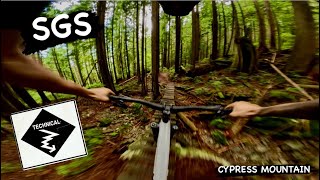
Traverses the flank paralleling CBR, exiting on the BLT. Close enough to the 2nd SB that
you can see it. Climb up from Blind Skier and descend a bench-cut trail with some bridges and TTF.

This trail is unsanctioned.

Recent Activity on Trail

Past Week
  • 0 rides
  •  
6 Months
  • 16 rides
  • 9 miles avg distance
All
  • 157 rides
  • Last: Jun 25, 2026
c1c2c3c4
January
February
March
April
May
June
July
August
September
October
November
December
update trails status or condition

SGS Trail Reports

statusdatedescription
Apr 26, 2026 @ 9:11pm (America/Vancouver)
Apr 26, 2026
The big wood feature near the end is missing a few pieces
Oct 27, 2024 @ 4:16pm
Oct 27, 2024
Sopping wet. Cleared some drains, cleared some small fallen trees and tried to re-route some of the new streams from running across the trail....
Aug 9, 2024 @ 3:01pm
Aug 9, 2024
Added some new supports and more nails on the roll/drop move on the alt exit at the bottom. Should last another few months now, but the stringers...
May 23, 2024 @ 4:58pm
May 23, 2024
Two trees down at the end of the trail, need a saw to chop it up. One tree is over another and it very heavy, tried ti move it and wouldn’t budge
Mar 30, 2024 @ 1:16pm
Mar 30, 2024
Big blow down at the top of the trail, need a proper saw to clear.
more »
Status:
on Apr 26, 2026
Ideal
Avg: 4.16 (13 votes)
Your vote: 0

view (572)
close
3D
Trail Conditions
  • Unknown
  • Snow Groomed
  • Snow Packed
  • Snow Covered
  • Snow Cover Partial
  • Freeze/thaw Cycle
  • Icy
  • Prevalent Mud
  • Wet
  • Variable
  • Ideal
  • Dry
  • Very Dry
Trail Flow (Ridden Direction)
Trailforks scans users ridelogs to determine the most popular direction each trail is ridden. A good flowing trail network will have most trails flowing in a single direction according to their intension.
The colour categories are based on what percentage of riders are riding a trail in its intended direction.
  • > 96%
  • > 90%
  • > 80%
  • > 70%
  • > 50%
  • < 50%
  • bi-directional trail
  • no data
Trail Last Ridden
Trailforks scans ridelogs to determine the last time a trail was ridden.
  • < 2 days
  • < 1 week
  • < 2 weeks
  • < 1 month
  • < 6 months
  • > 6 months
Trail Ridden Direction
The intended direction a trail should be ridden.
  • Downhill Only
  • Downhill Primary
  • Both Directions
  • Uphill Primary
  • Uphill Only
  • One Direction
Contribute Details
Colors indicate trail is missing specified detail.
  • Description
  • Photos
  • Description & Photos
  • Videos
Trail Popularity ?
Trailforks scans ridelogs to determine which trails are ridden the most in the last 9 months. Trails are compared with nearby trails in the same city region with a possible 25 colour shades. Think of this as a heatmap, more rides = more kinetic energy = warmer colors.
  • most popular
  • popular
  • less popular
  • not popular
ATV/ORV/OHV Filter
Max Vehicle Width
inches
US Cell Coverage
Legend
cell carrier legend

Radar Time
Activity Recordings
Trailforks uses anonymized public activity data. ?
Activity Recordings
Trailforks uses anonymized public activity data. ?
Personal Heatmap
Activity Types
all / none
Options
2
Date range month
Winter Trails
Warning A routing network for winter maps does not exist. Selecting trails using the winter trails layer has been disabled.
Missing Trails
Most Popular
Least Popular
Trails are colored based on popularity. The more popular a trail is, the more red. Less popular trails trend towards green.
Jump Magnitude Heatmap
Heatmap of where riders jump on trails. Zoom in to see individual jumps, click circles to view jump details.
BC Backroad Status

Service Road Atlas is a free to use, community-driven service for viewing and creating reports on the numerous back-country service roads around B.C. and Alberta.

map legend
Slope Aspect
Direction the slope faces
Flat N NE E SE S SW W NW
Trails Deemphasized
Trails are shown in grey.
disable
Only show trails with no bike usage.
Enable
Suggested Layers
Based on selected activity type

    Save the current map location and zoom level as your default home location whenever this page is loaded.

    Save
        Directions to sgs trailhead (49.362460, -123.202030)

        Photos

        30 more »
        544 |
        Apr 1, 2014 @ 11:42am
        Apr 1, 2014
        69 |
        May 14, 2023 @ 4:56pm
        May 14, 2023
        71 |
        May 14, 2023 @ 4:56pm
        May 14, 2023
        110 |
        May 14, 2023 @ 4:56pm
        May 14, 2023

        Videos

        7 more »
        youtuber The Scariest Trails On The Mountain
        11:15 | 525 | Nov 27, 2021 , West Vancouver
        youtuber SGS | Single Black trail | Cypress Mountain
        2:40 | 114 | Sep 3, 2024 , West Vancouver
        youtuber This Trail Is No Joke
        11:48 | 334 | Aug 19, 2023 , West Vancouver
        youtuber A North Shore Skinny on the Edge of a Cliff
        5:29 | 411 | Jun 18, 2021 , West Vancouver

        Trail Lists

        Routes with this trail

        13 miles 2,885 ft 8
        super fun trails, hard warm up though
        4 miles 431 ft 11 Shuttled
        This is one of our favorite routes on the North Shore and is featured in Freehub Magazine's Sea to Sky...

        5 Reviews & Comments


        We hope you've been enjoying Trailforks!

        Create a FREE account to view trail comments and much more.

        • #272 - 8,113 views

        Frequently Asked Questions About SGS

        Where is SGS located?
        SGS is located in Cypress Mountain, West Vancouver, British Columbia, Canada. It is part of the Cypress Mountain trail network. The trailhead is located at coordinates 49.36246, -123.20203.
        How hard is SGS?
        SGS is rated as Black Diamond difficulty.
        What is the elevation gain for SGS?
        SGS has 36 m of elevation gain. The trail has 140 m of elevation descent. The elevation ranges from 622 m to 751 m.
        How long is SGS?
        SGS is 967.0 m long. The trail type is singletrack.

        Hit the Trail

        Open in App

        Get this trail on your phone instantly.
        open trail in app

        Download Trail

        Save to wishlist, Garmin & download.
        save the trail

        Find Related Routes

        Find routes and users activities that include this trail.
        find routes for this trail

        You must enter a description before submitting.