more stats
1,762 ft
Distance
3 ft
Climb
-425 ft
Descent
00:08:40
Avg time
-423 ft
Altitude change
2,080 ft
Altitude min
2,503 ft
Altitude max
2,503 ft
Altitude start
2,080 ft
Altitude end
-24%
Grade
-58.9%
Grade max
11%
Grade min
46 ft
Distance climb
1,627 ft
Distance down
89 ft
Distance flat
00:08:40
Avg time

Shitacker Details

  • Activities
    • Mountain Bike
    • E-Bike
  • Riding Area
    Nelson's North Shore
    Nelson, British Columbia
  • Difficulty Rating
  • Local Popularity
    65 in Mountain Biking [+]
    • 50 in E-Biking
  • Global Ranking
    #82031 in Mountain Biking [+]
    • #83824 in E-Biking
  • Trail Type
    Singletrack
  • Bike Type
    DH, AM
  • Direction
    Downhill Primary
    Popular Direction Shown
  • Dogs Allowed
    Yes
  • eBike Allowed
    Yes up to Class 1
  • TTFs on Trail
    Bridge, Gap Jump, Rock Face

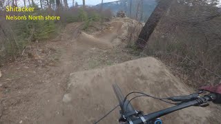
If you want to check out what the pros are hitting this is a cool trail. The top has a massive jump line but easy around routes are available for all features (definitely a look before you leap situation). It then turns into rocky downhill with a few slabs before merging back onto lower Nooner.

Trail Supporters
Local Trail Association

Recent Activity on Trail

Past Week
  • 1 rides
  • 8 miles average
6 Months
  • 5 rides
  • 6 miles avg distance
All
  • 36 rides
  • Last: Jun 13, 2026
c1c2c3c4
January
February
March
April
May
June
July
August
September
October
November
December
update trails status or condition

Shitacker Trail Reports

statusdatedescription
Jul 23, 2025 @ 3:50pm
Jul 23, 2025
all trees cleared off trail
Jul 20, 2025 @ 10:14am
Jul 20, 2025
Large tree across trail at the top. Smaller tree down across bridge before slabs.
May 16, 2023 @ 2:25pm
May 16, 2023
Apr 2, 2022 @ 10:57am
Apr 2, 2022
Large tree down across trail, blocking trail
Dec 3, 2021 @ 12:07pm
Dec 3, 2021
Snow free, with some sections of deadly hoarfrost at the top of the trail.
more »
Status:
on Jul 23, 2025
Ideal
Avg: 4.15 (7 votes)
Your vote: 0

view (380)
close
3D
Trail Conditions
  • Unknown
  • Snow Groomed
  • Snow Packed
  • Snow Covered
  • Snow Cover Partial
  • Freeze/thaw Cycle
  • Icy
  • Prevalent Mud
  • Wet
  • Variable
  • Ideal
  • Dry
  • Very Dry
Trail Flow (Ridden Direction)
Trailforks scans users ridelogs to determine the most popular direction each trail is ridden. A good flowing trail network will have most trails flowing in a single direction according to their intension.
The colour categories are based on what percentage of riders are riding a trail in its intended direction.
  • > 96%
  • > 90%
  • > 80%
  • > 70%
  • > 50%
  • < 50%
  • bi-directional trail
  • no data
Trail Last Ridden
Trailforks scans ridelogs to determine the last time a trail was ridden.
  • < 2 days
  • < 1 week
  • < 2 weeks
  • < 1 month
  • < 6 months
  • > 6 months
Trail Ridden Direction
The intended direction a trail should be ridden.
  • Downhill Only
  • Downhill Primary
  • Both Directions
  • Uphill Primary
  • Uphill Only
  • One Direction
Contribute Details
Colors indicate trail is missing specified detail.
  • Description
  • Photos
  • Description & Photos
  • Videos
Trail Popularity ?
Trailforks scans ridelogs to determine which trails are ridden the most in the last 9 months. Trails are compared with nearby trails in the same city region with a possible 25 colour shades. Think of this as a heatmap, more rides = more kinetic energy = warmer colors.
  • most popular
  • popular
  • less popular
  • not popular
ATV/ORV/OHV Filter
Max Vehicle Width
inches
US Cell Coverage
Legend
cell carrier legend

Radar Time
Activity Recordings
Trailforks uses anonymized public activity data. ?
Activity Recordings
Trailforks uses anonymized public activity data. ?
Personal Heatmap
Activity Types
all / none
Options
2
Date range month
Winter Trails
Warning A routing network for winter maps does not exist. Selecting trails using the winter trails layer has been disabled.
Missing Trails
Most Popular
Least Popular
Trails are colored based on popularity. The more popular a trail is, the more red. Less popular trails trend towards green.
Jump Magnitude Heatmap
Heatmap of where riders jump on trails. Zoom in to see individual jumps, click circles to view jump details.
BC Backroad Status

Service Road Atlas is a free to use, community-driven service for viewing and creating reports on the numerous back-country service roads around B.C. and Alberta.

map legend
Slope Aspect
Direction the slope faces
Flat N NE E SE S SW W NW
Trails Deemphasized
Trails are shown in grey.
disable
Only show trails with no bike usage.
Enable
Suggested Layers
Based on selected activity type

    Save the current map location and zoom level as your default home location whenever this page is loaded.

    Save
        Directions to shitacker trailhead (49.617460, -117.118450)

        Photos

        75 more »
        261 |
        Jul 20, 2022 @ 4:49pm
        Jul 20, 2022
        545 |
        Jul 20, 2022 @ 4:49pm
        Jul 20, 2022
        187 |
        Jul 20, 2022 @ 4:49pm
        Jul 20, 2022
        262 |
        Jul 20, 2022 @ 4:49pm
        Jul 20, 2022

        Videos

        2 more »
        youtuber Shitacker - Nelson, BC
        3:07 | 276 | Apr 19, 2024 , Nelson
        Shitacker
        3:08 | 479 | Apr 26, 2022 , Nelson

        Trail Products

        2 Reviews & Comments


        We hope you've been enjoying Trailforks!

        Create a FREE account to view trail comments and much more.

        • By BCpovTF Pro & contributors
        • #2289 - 5,952 views

        Frequently Asked Questions About Shitacker

        Where is Shitacker located?
        Shitacker is located in Nelson's North Shore, Nelson, British Columbia, Canada. It is part of the Nelson's North Shore trail network. The trailhead is located at coordinates 49.61746, -117.11845.
        How hard is Shitacker?
        Shitacker is rated as Black Diamond difficulty. The average grade is 24%.
        What is the elevation gain for Shitacker?
        Shitacker has 3 ft of elevation gain. The trail has 425 ft of elevation descent. The elevation ranges from 2,080 ft to 2,503 ft.
        Is Shitacker a point to point trail?
        Shitacker is not a point to point trail. The direction is Downhill Primary. The trail type is singletrack.

        Hit the Trail

        Open in App

        Get this trail on your phone instantly.
        open trail in app

        Download Trail

        Save to wishlist, Garmin & download.
        save the trail

        Find Related Routes

        Find routes and users activities that include this trail.
        find routes for this trail

        You must enter a description before submitting.