more stats
2,375 ft
Distance
2 ft
Climb
-170 ft
Descent
00:03:11
Avg time
-165 ft
Altitude change
1,693 ft
Altitude min
1,863 ft
Altitude max
1,863 ft
Altitude start
1,696 ft
Altitude end
-7%
Grade
-40.2%
Grade max
5.7%
Grade min
52 ft
Distance climb
2,103 ft
Distance down
217 ft
Distance flat
00:03:11
Avg time

Simpson Details

  • Activities
    • Mountain Bike
    • Winter Fat Bike
  • Riding Area
    Knox Mountain Park
    Kelowna, British Columbia
  • Difficulty Rating
  • Voted Difficulty
    Blue (1 vote)
  • Local Popularity
    100 in Mountain Biking
  • Global Ranking
    #21621 in Mountain Biking
  • Trail Type
    Singletrack
  • Bike Type
    DH, AM, XC, Fat
  • Direction
    Downhill Only
    Popular Direction Shown
  • Physical Rating
    Moderate
  • Trail Visibility
    Always easy to follow
  • Dogs Allowed
    Yes
  • TTFs on Trail
    Berm, Jump, Gap Jump, Pump Track
  • Land Owner
    city of kelowna

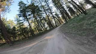
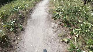
Downhill pumptrack style trail with berms, woops, doubles, step downs. Designed as a "youth" skills trail, some sections can be "tight" for longer bikes, bigger wheels and bigger dudes... but its super fun

Access Info

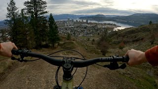
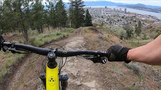
Trailhead is at the Knox Mountain Drive and Marsh Access Road junction. By starting up the access road a little ways, you can add in a wallride on the left before dropping in to Simpson.

Local Trail Association

Recent Activity on Trail

Past Week
  • 22 rides
  • 10 miles average
6 Months
  • 627 rides
  • 10 miles avg distance
All
  • 3,575 rides
  • Last: Jun 25, 2026
c1c2c3c4
January
February
March
April
May
June
July
August
September
October
November
December
Status:
on Jun 21, 2026
Dry
Avg: 4.25 (26 votes)
Your vote: 0

view (24,855)
close
3D
Trail Conditions
  • Unknown
  • Snow Groomed
  • Snow Packed
  • Snow Covered
  • Snow Cover Partial
  • Freeze/thaw Cycle
  • Icy
  • Prevalent Mud
  • Wet
  • Variable
  • Ideal
  • Dry
  • Very Dry
Trail Flow (Ridden Direction)
Trailforks scans users ridelogs to determine the most popular direction each trail is ridden. A good flowing trail network will have most trails flowing in a single direction according to their intension.
The colour categories are based on what percentage of riders are riding a trail in its intended direction.
  • > 96%
  • > 90%
  • > 80%
  • > 70%
  • > 50%
  • < 50%
  • bi-directional trail
  • no data
Trail Last Ridden
Trailforks scans ridelogs to determine the last time a trail was ridden.
  • < 2 days
  • < 1 week
  • < 2 weeks
  • < 1 month
  • < 6 months
  • > 6 months
Trail Ridden Direction
The intended direction a trail should be ridden.
  • Downhill Only
  • Downhill Primary
  • Both Directions
  • Uphill Primary
  • Uphill Only
  • One Direction
Contribute Details
Colors indicate trail is missing specified detail.
  • Description
  • Photos
  • Description & Photos
  • Videos
Trail Popularity ?
Trailforks scans ridelogs to determine which trails are ridden the most in the last 9 months. Trails are compared with nearby trails in the same city region with a possible 25 colour shades. Think of this as a heatmap, more rides = more kinetic energy = warmer colors.
  • most popular
  • popular
  • less popular
  • not popular
ATV/ORV/OHV Filter
Max Vehicle Width
inches
US Cell Coverage
Legend
cell carrier legend

Radar Time
Activity Recordings
Trailforks uses anonymized public activity data. ?
Activity Recordings
Trailforks uses anonymized public activity data. ?
Personal Heatmap
Activity Types
all / none
Options
2
Date range month
Winter Trails
Warning A routing network for winter maps does not exist. Selecting trails using the winter trails layer has been disabled.
Missing Trails
Most Popular
Least Popular
Trails are colored based on popularity. The more popular a trail is, the more red. Less popular trails trend towards green.
Jump Magnitude Heatmap
Heatmap of where riders jump on trails. Zoom in to see individual jumps, click circles to view jump details.
BC Backroad Status

Service Road Atlas is a free to use, community-driven service for viewing and creating reports on the numerous back-country service roads around B.C. and Alberta.

map legend
Slope Aspect
Direction the slope faces
Flat N NE E SE S SW W NW
Trails Deemphasized
Trails are shown in grey.
disable
Only show trails with no bike usage.
Enable
Suggested Layers
Based on selected activity type

    Save the current map location and zoom level as your default home location whenever this page is loaded.

    Save
        Directions to simpson trailhead (49.912340, -119.478350)

        Photos

        34 more »
        95 |
        Jul 21, 2023 @ 1:29am
        Jul 21, 2023
        157 |
        Apr 28, 2022 @ 10:36pm
        Apr 28, 2022
        209 |
        Apr 11, 2021 @ 10:13am
        Apr 11, 2021
        148 |
        Apr 13, 2021 @ 11:09pm
        Apr 13, 2021

        Videos

        10 more »
        Knox Mtn | Raw MTB | Kelowna BC
        4:53 | 552 | Apr 12, 2022 , Kelowna
        Simpson Trail SO MUCH FUN! Ten year old riding!
        2:37 | 1024 | Apr 23, 2021 , Kelowna
        Simpson to Bottom (Uncut)
        5:38 | 923 | Apr 27, 2020 , Kelowna
        Simpson Trail //  Knox Mountain Park (4K)
        0:25 | 1524 | Jul 9, 2018 , Kelowna

        Routes with this trail

        4.0 5 miles 1,164 ft 5 Loop
        For this Sovereign Cycle group ride we're heading up the (instead of the road) to the upper lookout. From...
        5 miles 1,104 ft 8 Loop
        A fun loop of Knox with a small traverse on the way down cutting off of to ride all of .
        1 mile 45 ft 3 Race
        Riders will climb to the top of Marlin's Spike self-guided. The stage will begin at the top of Marlin's...

        1 Review & Comments


        We hope you've been enjoying Trailforks!

        Create a FREE account to view trail comments and much more.

        • By smokeTF Pro Simpcw & contributors
        • #19270 - 8,624 views

        Frequently Asked Questions About Simpson

        Where is Simpson located?
        Simpson is located in Knox Mountain Park, Kelowna, British Columbia, Canada. It is part of the Knox Mountain Park trail network. The trailhead is located at coordinates 49.91234, -119.47835.
        How hard is Simpson?
        Simpson is rated as Blue difficulty. The physical rating is Moderate. The average grade is 7%.
        What is the elevation gain for Simpson?
        Simpson has 2 ft of elevation gain. The trail has 170 ft of elevation descent. The elevation ranges from 1,693 ft to 1,863 ft.
        Is Simpson a point to point trail?
        Yes, Simpson is a point to point trail. The direction is Downhill Only. The trail type is singletrack.

        Hit the Trail

        Open in App

        Get this trail on your phone instantly.
        open trail in app

        Download Trail

        Save to wishlist, Garmin & download.
        save the trail

        Find Related Routes

        Find routes and users activities that include this trail.
        find routes for this trail

        You must enter a description before submitting.