2,159 ft
Distance
124 ft
Climb
00:07:28
Avg time
Skidder Details
-
Activities
- Mountain Bike
- Hike
- Trail Running
-
Riding AreaWoodlot
Maple Ridge, British Columbia -
Difficulty Rating
-
Trail TypeDirt/Gravel Road
-
Bike TypeAdaptive MTB, Gravel
-
DirectionUphill PrimaryPopular direction shown
-
Climb DifficultyBlue
-
Physical RatingModerate
-
Dogs AllowedYes
-
eBike Allowed
-
Ride in RainYes
-
Local Popularity90 in Mountain Biking [+]
- 45 in Trail Running
- 95 in Hiking
-
Land Owner
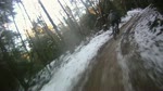
This forest service road is the main road used by MTB riders, hikers and forest service vehicles to enter and climb to the top of "The Woodlot". Access by vehicles turns west at the powerlines but forks and continues north to access more MTB trails.
Access Info
The end of 287th (north) off Dewdney Trunk Rd or 28101 Dewdney Trunk Rd
Local Trail Association
-
Please consider joining or donating to the local trail association to supportdonate to earn trail karma!
trail development & maintenance.
Traditionally Indigenous Territory
More Stats for Skidder mountain bike trail trail
-
Altitude change126 ft
-
Altitude min708 ft
-
Altitude max834 ft
-
Altitude start708 ft
-
Altitude end833 ft
-
Grade5.8%
-
Grade max1.4%
-
Grade min19.9%
-
Distance climb2,159 ft
-
Avg time00:07:28
-
Avg reverse time00:06:19
- view trail stats
close
3D
Trail Conditions
- Unknown
- Snow Groomed
- Snow Packed
- Snow Covered
- Snow Cover Partial
- Freeze/thaw Cycle
- Icy
- Prevalent Mud
- Wet
- Variable
- Ideal
- Dry
- Very Dry
Trail Flow (Ridden Direction)
Trailforks scans users ridelogs to determine the most popular direction each trail is ridden. A good flowing trail network will have most trails flowing in a single direction according to their intension.
The colour categories are based on what percentage of riders are riding a trail in its intended direction.
- > 96%
- > 90%
- > 80%
- > 70%
- > 50%
- < 50%
- bi-directional trail
- no data
Trail Last Ridden
Trailforks scans ridelogs to determine the last time a trail was ridden.
- < 2 days
- < 1 week
- < 2 weeks
- < 1 month
- < 6 months
- > 6 months
Trail Ridden Direction
The intended direction a trail should be ridden.
- Downhill Only
- Downhill Primary
- Both Directions
- Uphill Primary
- Uphill Only
- One Direction
Contribute Details
Colors indicate trail is missing specified detail.
- Description
- Photos
- Description & Photos
- Videos
Trail Popularity ?
Trailforks scans ridelogs to determine which trails are ridden the most in the last 9 months.
Trails are compared with nearby trails in the same city region with a possible 25 colour shades.
Think of this as a heatmap, more rides = more kinetic energy = warmer colors.
- most popular
- popular
- less popular
- not popular
ATV/ORV/OHV Filter
Max Vehicle Width
inches
US Cell Coverage
Legend
Radar Time
x
Activity Recordings
Trailforks users anonymized public ridelogs from the past 6 months.
- mountain biking recent
- mountain biking (>6 month)
- hiking (1 year)
- moto (1 year)
Activity Recordings
Trailforks users anonymized public skilogs from the past 12 months.
- Downhill Ski
- Backcountry Ski
- Nordic Ski
- Snowmobile
Winter Trails
Warning
A routing network for winter maps does not exist. Selecting trails using the winter trails layer has been disabled.
x
Missing Trails
Most Popular
Least Popular
Trails are colored based on popularity. The more popular a trail is, the more red. Less popular trails trend towards green.
Jump Magnitude Heatmap
Heatmap of where riders jump on trails. Zoom in to see individual jumps, click circles to view jump details.
Trails Deemphasized
Trails are shown in grey.
Only show trails with NO bikes.
Save the current map location and zoom level as your default home location whenever this page is loaded.
Save
Directions to skidder trailhead
(49.227100, -122.427580)
update trails status or condition
Skidder Trail Reports
view all reports »
Recent Ridelog Activity on Trail
Past Week
- 13 rides
- 7 miles avg distance
6 Months
- 191 rides
- 6 miles avg distance
All
- 1,325 rides
- Last: Jan 17, 2025
Photos
more »
Routes with this trail
more »
Trail Products
-
Fraser Valley GuideBook
3 Reviews & Comments
We hope you've been enjoying Trailforks!
Create a FREE account to view trail comments and much more.
Nearby Trails
- Woodlot Fsr Main 3,153 ft
- Access Road 3,215 ft
- Access2 3,219 ft
- Access5 3,232 ft
- Shotgun 3,422 ft
- By canadaka Trailforks & contributors
- #495 - 4,441 views
- follow/subscribe
- login to download gpx or kml files.
You must enter a description before submitting.