Supporters, Builders, Maintainers & Land Managers of Slickrock (practice) Trail
BLMLand Manager
Details
-
Activities
- Mountain Bike
- E-Bike
- Hike
- Trail Running
- Dirtbike/Moto
-
Riding AreaSand Flats Recreation Area
Moab, Utah -
Difficulty Rating
-
Trail TypeSingletrack
-
Bike TypeXC, Adaptive MTB
-
DirectionBoth DirectionsPopular in reverse
-
Climb DifficultyBlue
-
Physical RatingModerate
-
Dogs AllowedYes
-
eBike AllowedYes up to Class 1
-
Global Ranking#555 in Mountain Biking [+]
- #1163 in E-Biking
- #13181 in Trail Running
- #3623 in Hiking
- #2532 in Dirtbiking
-
Local Popularity95 in Mountain Biking [+]
- 100 in E-Biking
- 90 in Trail Running
- 90 in Hiking
- 90 in Dirtbiking
-
Land OwnerBLM
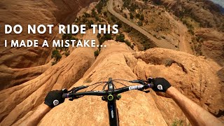
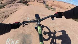
This trail makes a good introduction to the type of terrain you'll find on the main loop, but at a more moderate level for those who want to ease into it. Still, it presents some significant obstacles and should not be taken lightly. True beginners probably won't enjoy a ride here.
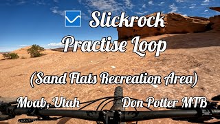
Just a quarter mile into the main Slickrock Trail, fork right at the painted junction to start the Practice Loop. Follow the white dashes along a series of sandstone domes, followed by a quick descent toward the Echo Canyon viewpoint. It's worth getting off your bike and hiking to the edge of the cliffs for a closer look at this box canyon.
Continue along the dashed line as it winds up and over more low fins and across sandy washes back towards the main trail, with a number of short but steep climbs and drops. You'll rejoin the Slickrock Trail around the 3/4 mile mark. If you're up for 10 more miles of slickrock, turn right for the full loop. If not, turn left for a quick return to the trailhead.
Adaptive Bike Info
After some practice, advanced adaptive riders can most likely do this trail solo. There are a few steep ledgy spots (two with deep sand leading up to them) that adaptive riders will most likely need an assist for and three or four off-camber situations possibly requiring a spot for riders with higher injuries.
Local Trail Association
-
Please consider joining or donating to the local trail association to supportdonate to earn trail karma!
trail development & maintenance.
Traditionally Indigenous Territory
More Stats for Slickrock (practice) mountain bike trail trail
-
Altitude change76 ft
-
Altitude min4,549 ft
-
Altitude max4,672 ft
-
Altitude start4,572 ft
-
Altitude end4,648 ft
-
Grade1.169%
-
Grade max-108.628%
-
Grade min33.566%
-
Distance climb3,601 ft
-
Distance down2,217 ft
-
Distance flat705 ft
-
Avg time00:19:58
-
Avg reverse time00:23:18
- view trail stats
- Unknown
- Snow Groomed
- Snow Packed
- Snow Covered
- Snow Cover Inadequate
- Freeze/thaw Cycle
- Icy
- Prevalent Mud
- Wet
- Variable
- Ideal
- Dry
- Very Dry
The colour categories are based on what percentage of riders are riding a trail in its intended direction.
- > 96%
- > 90%
- > 80%
- > 70%
- > 50%
- < 50%
- bi-directional trail
- no data
- < 2 days
- < 1 week
- < 2 weeks
- < 1 month
- < 6 months
- > 6 months
- Downhill Only
- Downhill Primary
- Both Directions
- Uphill Primary
- Uphill Only
- One Direction
- Description
- Photos
- Description & Photos
- Videos
- most popular
- popular
- less popular
- not popular
- mountain biking recent
- mountain biking (>6 month)
- hiking (1 year)
- moto (1 year)
- Downhill Ski
- Backcountry Ski
- Nordic Ski
- Snowmobile
Save the current map location and zoom level as your default home location whenever this page is loaded.
SaveSlickrock (practice) Trail Reports
Recent Ridelog Activity on Trail
Past Week
- 3 rides
- 7 miles avg distance
6 Months
- 325 rides
- 8 miles avg distance
All
- 3,282 rides
- Last: Feb 6, 2023
Photos
Routes with this trail
-
+ 1
Videos
Nearby Trails
- Slickrock Spur 3,215 ft
- Above Abyss 4,078 ft
- Slickrock 4,416 ft
- Slickrock 1 mile
- Kokopelli (sand Flats Rd) 1 mile
Sand Flats Recreation Area
- embed Slickrock (practice) trail on your website
- By todd
Trailforks & contributors
- #8860 - 7,222 views
- subscribe
- login to download gpx or kml files.