1.6 miles
Distance
191 ft
Climb
-862 ft
Descent
00:12:41
Avg time
Snake Pit Details
-
Activities
- Mountain Bike
- E-Bike
-
Riding AreaSilver Star Bike Park
Vernon, British Columbia -
Difficulty Rating
-
Trail TypeSingletrack
-
Bike TypeDH, AM, XC
-
DirectionDownhill OnlyPopular direction shown
-
Physical RatingModerate
-
SeasonSummer and fall
-
Dogs AllowedYes
-
eBike Allowed
-
TTFs on TrailBridge
-
Global Ranking#36016 in Mountain Biking
-
Local Popularity50 in Mountain Biking [+]
- 85 in E-Biking
-
Land Owner
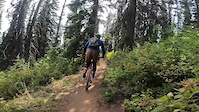
Is an XC inspired trail that will take you from Hub One back to the village. This trail has numerous switch backs and wide wooden bridges. If you’re looking for a bit of exercise and a great XC inspired downhill run, look no further.
Access Info
Access from Hub one.
Local Trail Association
-
Please consider joining or donating to the local trail association to support
trail development & maintenance.
Traditionally Indigenous Territory
More Stats for Snake Pit mountain bike trail trail
-
Altitude change-671 ft
-
Altitude min5,318 ft
-
Altitude max5,991 ft
-
Altitude start5,989 ft
-
Altitude end5,318 ft
-
Grade-7.763%
-
Grade max-31.451%
-
Grade min24.266%
-
Distance climb1,837 ft
-
Distance down1 mile
-
Distance flat216 ft
-
Avg time00:12:41
-
Avg reverse time00:19:16
- view trail stats
close
3D
Trail Conditions
- Unknown
- Snow Groomed
- Snow Packed
- Snow Covered
- Snow Cover Partial
- Freeze/thaw Cycle
- Icy
- Prevalent Mud
- Wet
- Variable
- Ideal
- Dry
- Very Dry
Trail Flow (Ridden Direction)
Trailforks scans users ridelogs to determine the most popular direction each trail is ridden. A good flowing trail network will have most trails flowing in a single direction according to their intension.
The colour categories are based on what percentage of riders are riding a trail in its intended direction.
- > 96%
- > 90%
- > 80%
- > 70%
- > 50%
- < 50%
- bi-directional trail
- no data
Trail Last Ridden
Trailforks scans ridelogs to determine the last time a trail was ridden.
- < 2 days
- < 1 week
- < 2 weeks
- < 1 month
- < 6 months
- > 6 months
Trail Ridden Direction
The intended direction a trail should be ridden.
- Downhill Only
- Downhill Primary
- Both Directions
- Uphill Primary
- Uphill Only
- One Direction
Contribute Details
Colors indicate trail is missing specified detail.
- Description
- Photos
- Description & Photos
- Videos
Trail Popularity ?
Trailforks scans ridelogs to determine which trails are ridden the most in the last 9 months.
Trails are compared with nearby trails in the same city region with a possible 25 colour shades.
Think of this as a heatmap, more rides = more kinetic energy = warmer colors.
- most popular
- popular
- less popular
- not popular
ATV/ORV/OHV Filter
Max Vehicle Width
inches
US Cell Coverage
Legend
Radar Time
x
Activity Recordings
Trailforks users anonymized public ridelogs from the past 6 months.
- mountain biking recent
- mountain biking (>6 month)
- hiking (1 year)
- moto (1 year)
Activity Recordings
Trailforks users anonymized public skilogs from the past 12 months.
- Downhill Ski
- Backcountry Ski
- Nordic Ski
- Snowmobile
Winter Trails
Warning
A routing network for winter maps does not exist. Selecting trails using the winter trails layer has been disabled.
x
Missing Trails
Most Popular
Least Popular
Trails are colored based on popularity. The more popular a trail is, the more red. Less popular trails trend towards green.
Jump Magnitude Heatmap
Heatmap of where riders jump on trails. Zoom in to see individual jumps, click circles to view jump details.
Trails Deemphasized
Trails are shown in grey.
Only show trails with NO bikes.
Save the current map location and zoom level as your default home location whenever this page is loaded.
Save
Directions to snake-pit trailhead
(50.372770, -119.058140)
update trails status or condition
Snake Pit Trail Reports
view all reports »
Recent Ridelog Activity on Trail
Past Week
- 0 rides
6 Months
- 0 rides
All
- 456 rides
- Last: Aug 14, 2021
Photos
more »
Trail Lists
-
Silver Star Tech Trails
8 trails
Routes with this trail
more »
4 Reviews & Comments
We hope you've been enjoying Trailforks!
Create a FREE account to view trail comments and much more.
Videos
more »
Nearby Trails
- Shazam 59 ft
- Sundance 79 ft
- Pipe Dream 157 ft
- Chien Chaud 157 ft
- Rock Star 348 ft
Silver Star Bike Park
- By canadaka
Trailforks & contributors
- #3349 - 5,726 views
- follow/subscribe
- login to download gpx or kml files.
You must enter a description before submitting.