more stats
1.2 miles
Distance
-1,107 ft
Descent
00:07:41
Avg time
-1,107 ft
Altitude change
4,851 ft
Altitude min
5,957 ft
Altitude max
5,957 ft
Altitude start
4,852 ft
Altitude end
-18.2%
Grade
-38.3%
Grade max
1.8%
Grade min
36 ft
Distance climb
1 mile
Distance down
49 ft
Distance flat
00:07:41
Avg time

wolF Details

  • Activities
    • Mountain Bike
    • E-Bike
  • Riding Area
    Silver Star Mountain Park
    Vernon, British Columbia
  • Difficulty Rating
  • Voted Difficulty
    Blue (1 vote)
  • Local Popularity
    60 in Mountain Biking [+]
    • 80 in E-Biking
  • Global Ranking
    #72719 in Mountain Biking [+]
    • #32830 in E-Biking
  • Trail Type
    Singletrack
  • Bike Type
    DH
  • Physical Rating
    Hard
  • Season
    Summer
  • Dogs Allowed
    Yes
  • eBike Allowed
  • Land Owner

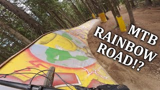
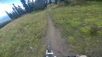
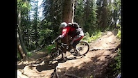
Is one of the original trails built at Silver Star. Don’t let the name fool you, this is a techy single track trail with switch backs and rooty sections. For the old school tech and fun trail you’ll enjoy this one.

Bike Park

Local Trail Association

Recent Activity on Trail

Past Week
  • 9 rides
  • 33 miles average
6 Months
  • 13 rides
  • 33 miles avg distance
All
  • 306 rides
  • Last: Jul 3, 2026
c1c2c3c4
January
February
March
April
May
June
July
August
September
October
November
December
update trails status or condition

wolF Trail Reports

statusdatedescription
Jun 18, 2026 @ 10:07pm (America/Vancouver)
Jun 18, 2026
Jun 18, 2026 @ 10:05pm (America/Vancouver)
Jun 18, 2026
Sep 23, 2025 @ 9:58am (America/Vancouver)
Sep 23, 2025
Thanks for another great season, ALL DH, Beowulf and upper XC trails are now closed. The Knoll XC will remain open until TBD.
Jun 21, 2025 @ 8:43am
Jun 21, 2025
Jun 20, 2025 @ 10:03am
Jun 20, 2025
more »
Status:
on Jun 18, 2026
Avg: 4.32 (22 votes)
Your vote: 0

view (2,490)
close
3D
Trail Conditions
  • Unknown
  • Snow Groomed
  • Snow Packed
  • Snow Covered
  • Snow Cover Partial
  • Freeze/thaw Cycle
  • Icy
  • Prevalent Mud
  • Wet
  • Variable
  • Ideal
  • Dry
  • Very Dry
Trail Flow (Ridden Direction)
Trailforks scans users ridelogs to determine the most popular direction each trail is ridden. A good flowing trail network will have most trails flowing in a single direction according to their intension.
The colour categories are based on what percentage of riders are riding a trail in its intended direction.
  • > 96%
  • > 90%
  • > 80%
  • > 70%
  • > 50%
  • < 50%
  • bi-directional trail
  • no data
Trail Last Ridden
Trailforks scans ridelogs to determine the last time a trail was ridden.
  • < 2 days
  • < 1 week
  • < 2 weeks
  • < 1 month
  • < 6 months
  • > 6 months
Trail Ridden Direction
The intended direction a trail should be ridden.
  • Downhill Only
  • Downhill Primary
  • Both Directions
  • Uphill Primary
  • Uphill Only
  • One Direction
Contribute Details
Colors indicate trail is missing specified detail.
  • Description
  • Photos
  • Description & Photos
  • Videos
Trail Popularity ?
Trailforks scans ridelogs to determine which trails are ridden the most in the last 9 months. Trails are compared with nearby trails in the same city region with a possible 25 colour shades. Think of this as a heatmap, more rides = more kinetic energy = warmer colors.
  • most popular
  • popular
  • less popular
  • not popular
ATV/ORV/OHV Filter
Max Vehicle Width
inches
US Cell Coverage
Legend
cell carrier legend

Radar Time
Activity Recordings
Trailforks uses anonymized public activity data. ?
Activity Recordings
Trailforks uses anonymized public activity data. ?
Personal Heatmap
Activity Types
all / none
Options
2
Date range month
Winter Trails
Warning A routing network for winter maps does not exist. Selecting trails using the winter trails layer has been disabled.
Missing Trails
Most Popular
Least Popular
Trails are colored based on popularity. The more popular a trail is, the more red. Less popular trails trend towards green.
Jump Magnitude Heatmap
Heatmap of where riders jump on trails. Zoom in to see individual jumps, click circles to view jump details.
BC Backroad Status

Service Road Atlas is a free to use, community-driven service for viewing and creating reports on the numerous back-country service roads around B.C. and Alberta.

map legend
Slope Aspect
Direction the slope faces
Flat N NE E SE S SW W NW
Trails Deemphasized
Trails are shown in grey.
disable
Only show trails with no bike usage.
Enable
Suggested Layers
Based on selected activity type

    Save the current map location and zoom level as your default home location whenever this page is loaded.

    Save
        Directions to wolf-3357 trailhead (50.371780, -119.057220)

        Photos

        4 more »
        380 |
        Aug 8, 2019 @ 12:00am
        Aug 8, 2019
        184 |
        Jul 26, 2019 @ 11:20pm
        Jul 26, 2019
        224 |
        Jul 26, 2019 @ 11:20pm
        Jul 26, 2019
        918 |
        Sep 26, 2014 @ 5:34pm
        Sep 26, 2014

        Videos

        5 more »
        This Bike Park Has it All | Silver Star
        1:18:07 | 224 | Sep 20, 2023 , Vernon
        Flow at Silverstar
        4:16 | 706 | Oct 6, 2015 , Vernon
        Crystal Rides Flow
        7:17 | 353 | Aug 8, 2015 , Vernon
        Flow Silver Star 2012
        8:25 | 246 | Jul 9, 2012 , Vernon

        Routes with this trail

        7 miles 924 ft 9
        Use Cross-Mountain Trail to head straight over to , then climb up to Paradise and the top of the...
        25 miles 3,936 ft 18 Loop Race
        Proposed Stage 2 Route for the 2015 Singletrack 6 Stage Race. Stage Date: Monday, July 27, 2015. See...
        20 miles 4,740 ft 13 Loop Race
        2024 Juliana Bombshell Enduro Brought to you by NOCS and Juliana Bicycles. Let's do this gals The route...

        3 Reviews & Comments


        We hope you've been enjoying Trailforks!

        Create a FREE account to view trail comments and much more.

        • By canadakaTF Pro Trailforks & contributors
        • #3357 - 5,813 views

        Frequently Asked Questions About wolF

        Where is wolF located?
        wolF is located in Silver Star Mountain Park, Vernon, British Columbia, Canada. It is part of the Silver Star Mountain Park trail network. The trailhead is located at coordinates 50.37178, -119.05722.
        How hard is wolF?
        wolF is rated as Black Diamond difficulty. The physical rating is Hard. The average grade is 18.2%.
        What is the elevation gain for wolF?
        The trail has 1,107 ft of elevation descent. The elevation ranges from 4,851 ft to 5,957 ft.
        How long is wolF?
        wolF is 1.2 miles long. The trail type is singletrack.

        Hit the Trail

        Open in App

        Get this trail on your phone instantly.
        open trail in app

        Download Trail

        Save to wishlist, Garmin & download.
        save the trail

        Find Related Routes

        Find routes and users activities that include this trail.
        find routes for this trail

        You must enter a description before submitting.