1.1 miles
Distance
240 ft
Climb
00:11:57
Avg time

Springbrook North Details

  • Activities
    • Mountain Bike
    • Hike
    • Trail Running
  • Riding Area
  • Difficulty Rating
  • Trail Type
    Singletrack
  • Direction
    Both Directions
  • Climb Difficulty
    Green
  • Physical Rating
    Easy
  • Trail Visibility
    Always easy to follow
  • Dogs Allowed
    Yes
  • eBike Allowed
  • Global Ranking
    #2976 in Mountain Biking [+]
    • #1992 in Trail Running
    • #6317 in Hiking
  • Local Popularity
    95 in Mountain Biking [+]
    • 75 in Trail Running
    • 70 in Hiking
  • Land Owner

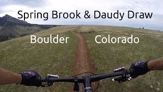
This trail is the easier direction to climb the Springbrook Loop. The trail hugs the hillside and is also a flowy descent. Half way through it flattens out on the top of the mesa and has great views of the Flatirons. Then it climbs again through the trees to the high point of the loop.

Access Info

Dogs are allowed on Springbrook North but not Springbrook South.

Local Trail Association
Traditionally Indigenous Territory
More Stats for Springbrook North multi-use trail trail
  • Altitude change
    242 ft
  • Altitude min
    6,001 ft
  • Altitude max
    6,243 ft
  • Altitude start
    6,001 ft
  • Altitude end
    6,243 ft
  • Grade
    4.1%
  • Grade max
    -0.9%
  • Grade min
    22.1%
  • Distance climb
    1 mile
  • Distance flat
    482 ft
  • Avg time
    00:11:57
  • Avg reverse time
    00:07:14
  • view trail stats
Status:
on Aug 30, 2023
Ideal
Avg: 4 (7 votes)
Your vote: 0

view (6,018)
close
3D
Trail Conditions
  • Unknown
  • Snow Groomed
  • Snow Packed
  • Snow Covered
  • Snow Cover Inadequate
  • Freeze/thaw Cycle
  • Icy
  • Prevalent Mud
  • Wet
  • Variable
  • Ideal
  • Dry
  • Very Dry
Trail Flow (Ridden Direction)
Trailforks scans users ridelogs to determine the most popular direction each trail is ridden. A good flowing trail network will have most trails flowing in a single direction according to their intension.
The colour categories are based on what percentage of riders are riding a trail in its intended direction.
  • > 96%
  • > 90%
  • > 80%
  • > 70%
  • > 50%
  • < 50%
  • bi-directional trail
  • no data
Trail Last Ridden
Trailforks scans ridelogs to determine the last time a trail was ridden.
  • < 2 days
  • < 1 week
  • < 2 weeks
  • < 1 month
  • < 6 months
  • > 6 months
Trail Ridden Direction
The intended direction a trail should be ridden.
  • Downhill Only
  • Downhill Primary
  • Both Directions
  • Uphill Primary
  • Uphill Only
  • One Direction
Contribute Details
Colors indicate trail is missing specified detail.
  • Description
  • Photos
  • Description & Photos
  • Videos
Trail Popularity ?
Trailforks scans ridelogs to determine which trails are ridden the most in the last 9 months. Trails are compared with nearby trails in the same city region with a possible 25 colour shades. Think of this as a heatmap, more rides = more kinetic energy = warmer colors.
  • most popular
  • popular
  • less popular
  • not popular
ATV/ORV/OHV Filter
Max Vehicle Width
inches

Radar Time
x Activity Recordings
Trailforks users anonymized public ridelogs from the past 6 months.
  • mountain biking recent
  • mountain biking (>6 month)
  • hiking (1 year)
  • moto (1 year)
Activity Recordings
Trailforks users anonymized public skilogs from the past 12 months.
  • Downhill Ski
  • Backcountry Ski
  • Nordic Ski
  • Snowmobile
Winter Trails
Warning A routing network for winter maps does not exist. Selecting trails using the winter trails layer has been disabled.
x Missing Trails
Most Popular
Least Popular
Trails are colored based on popularity. The more popular a trail is, the more red. Less popular trails trend towards green.
Jump Magnitude Heatmap
Heatmap of where riders jump on trails. Zoom in to see individual jumps, click circles to view jump details.
Trails Deemphasized
Trails are shown in grey.
disable
Only show trails with NO bikes.
enable

Save the current map location and zoom level as your default home location whenever this page is loaded.

Save
      Directions to springbrook-north trailhead (39.923870, -105.262870)
      update trails status or condition

      Springbrook North Trail Reports

      statusdatedescription
      Aug 30, 2023 @ 9:16am
      Aug 30, 2023
      Aug 27, 2023 @ 3:10am
      Aug 27, 2023
      Aug 13, 2023 @ 10:45am
      Aug 13, 2023
      Jul 6, 2023 @ 5:36pm
      Jul 6, 2023
      Jul 6, 2023 @ 10:54am
      Jul 6, 2023
      Heavy rains must have missed the Marshall/Doudy area. Trails were primo.
      view all reports »

      Recent Ridelog Activity on Trail

      Past Week
      • 26 rides
      • 13 miles avg distance
      6 Months
      • 659 rides
      • 14 miles avg distance
      All
      • 4,917 rides
      • Last: Sep 27, 2023

      Photos

      more »
      60 |
      Jun 21, 2021 @ 6:35am
      Jun 21, 2021
      109 |
      Jun 27, 2019 @ 11:39am
      Jun 27, 2019
      181 |
      Mar 20, 2019 @ 10:12am
      Mar 20, 2019

      Routes with this trail

      titledistance
      Marshall Mesa Doudy Draw Loop featured12 miles
      Dirty South22 miles
      Spring Brook Loop5 miles

      Trail Products

      Reviews / Comments

      No reviews yet, be the first to write a review or ask a question.
      Use trail reports to comment on trail conditions.


      We hope you've been enjoying Trailforks!

      Create a FREE account to view trail comments and much more.

      Videos

      more »
      youtuber Night riding Springbrook and Dowdy Draw with...
      5:01 | 446 | Sep 15, 2018 , Boulder
      youtuber Mountain Biking Spring Brook / Doudy Draw in...
      614 | Jun 20, 2017 , Boulder
      • By todd Trailforks & contributors
      • #13690 - 2,472 views
      • subscribe
      • flag
      • login to download gpx or kml files.