
more stats
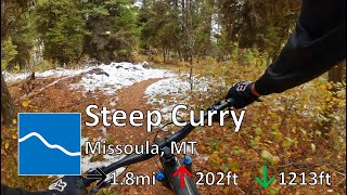
1.8 miles
Distance
132 ft
Climb
-1,141 ft
Descent
00:15:51
Avg time
-1,009 ft
Altitude change
4,326 ft
Altitude min
5,426 ft
Altitude max
5,335 ft
Altitude start
4,327 ft
Altitude end
-10.5%
Grade
-51.7%
Grade max
33.4%
Grade min
1,483 ft
Distance climb
1 mile
Distance down
289 ft
Distance flat
00:15:51
Avg time

Steep Curry Details

  • Activities
    • Mountain Bike
    • Horse
    • Hike
    • Trail Running
    • Snowshoe
  • Riding Area
  • Difficulty Rating
  • Voted Difficulty
    Blue (1 vote)
  • Local Popularity
    55 in Mountain Biking [+]
    • 55 in Trail Running
    • 5 in Hiking
    • 5 in Horseback
    • 5 in Snowshoeing
  • Global Ranking
    #134788 in Mountain Biking [+]
    • #140967 in Trail Running
    • #333792 in Hiking
    • #24419 in Horseback
    • #21768 in Snowshoeing
  • State Ranking
    #1,107 in Mountain Biking · Montana [+]
    • #1,635 in Trail Running
    • #3,938 in Hiking
    • #1,129 in Horseback
    • #661 in Snowshoeing
  • Hiking SAC Scale
    T2 Mountain Hiking
  • Trail Type
    Singletrack
  • Snow Grooming
    Backcountry
  • Bike Type
    AM, XC
  • Direction
    Downhill Primary
    Popular Direction Shown
  • Climb Difficulty
    Black Diamond
  • Physical Rating
    Moderate
  • Trail Visibility
    Always easy to follow
  • Season
    May - October
  • eBike Allowed
  • Land Owner
    USFS - Lolo National Forest

Steep, straight, and fast. Starts out with a little up and down, and then goes down the ridge for a super fast descent. You'll loose elevation in a hurry. If you hate yourself you can also climb up it.

Access Info

The last right before the overlook.

Tags
Trail Supporters
Local Trail Association
Traditionally Indigenous Territory

Recent Activity on Trail

Past Week
  • 0 rides
  •  
6 Months
  • 9 rides
  • 18 miles avg distance
All
  • 70 rides
  • Last: Sep 24, 2026
update trails status or condition

Steep Curry Trail Reports

statusdatedescription
Apr 21, 2026 @ 4:33pm (America/Denver)
Apr 21, 2026
There’s about 8 trees down and lots of debris. A couple of the trees are big and will need a chainsaw.
Oct 15, 2025 @ 12:30pm (America/Denver)
Oct 15, 2025
There is a large tree across the trail a few curves down from the top of the descent. It's going to require a chainsaw to clear.
Jul 12, 2025 @ 6:35am
Jul 12, 2025
Tree is clear and the trail has been brushed!
Jun 10, 2025 @ 5:51pm
Jun 10, 2025
One tree down at top.
Sep 22, 2024 @ 11:04am
Sep 22, 2024
more »
Status:
on Apr 21, 2026
Ideal
Avg: 3.24 (6 votes)
Your vote: 0

view (466)
close
      Directions to steep-curry trailhead (46.962190, -113.977620)

      Photos

      4 more »
      report
      mtb
      80 |
      Apr 17, 2021 @ 8:14pm
      Apr 17, 2021
      report
      mtb
      73 |
      May 3, 2019 @ 7:47am
      May 3, 2019
      report
      mtb
      98 |
      Jul 7, 2017 @ 9:15am
      Jul 7, 2017
      report
      trailrun
      54 |
      Oct 15, 2025 @ 2:30pm
      Oct 15, 2025

      Videos

      1 more »
      youtuber Steep Curry - The Rattlesnake - Missoula, MT
      mtb
      10:20 | 146 | Nov 9, 2022 , Missoula

      Routes with this trail

      ★ 1.0 • 30 miles • 7,136 ft • 38 •
      R1K Reverse Snake for September
      2.5 ★★★★★
      6 Ratings
      5 ★
      4 ★ 17%
      3 ★ 33%
      2 ★ 33%
      1 ★ 17%

      2 Reviews & Comments

      bizango-x bizango-x
      I agree with the other comment. Only ride cw. Not a great descent though. I feel like a lot of altitude was wasted.
      rmhdc
      If you ride this trail- only do it in a clockwise direction- it’s almost unclimbable counter clockwise!

      We hope you've been enjoying Trailforks!

      Create a FREE account to view all trail reviews and much more.

      • By lukeanders83TF Pro & contributors
      • #25618 - 2,260 views

      Frequently Asked Questions

      ▼ Where is Steep Curry located?
      Steep Curry is located in Rattlesnake National Recreation Area, Missoula, Montana, United States. It is part of the Rattlesnake National Recreation Area trail network. The trailhead is located at coordinates 46.96219, -113.97762.
      ▼ How hard is Steep Curry?
      Steep Curry is rated as Blue difficulty. The physical rating is Moderate. The average grade is 10.5%. The climb difficulty is rated Black Diamond.
      ▼ What is the elevation gain for Steep Curry?
      Steep Curry has 132 ft of elevation gain. The trail has 1,141 ft of elevation descent. The elevation ranges from 4,326 ft to 5,426 ft.
      ▼ Is Steep Curry a point to point trail?
      Steep Curry is not a point to point trail. The direction is Downhill Primary. The trail type is singletrack.
      ▼ How long is Steep Curry?
      Steep Curry is 1.8 miles long. The trail type is singletrack.
      ▼ Are dogs allowed on Steep Curry?
      There is no information about dogs being allowed on Steep Curry. Check with local trail managers or the trail page for the latest access rules.
      ▼ When is the best time of year to ride Steep Curry?
      Steep Curry is best visited during: May - October.
      ▼ How do I access Steep Curry? Where is the closest parking trailhead?
      The closest parking and trailhead locations to Steep Curry are: View all parking locations in the area.
      ▼ How long does it take to ride Steep Curry?
      Based on recorded activities, it takes an average of 16 minutes to ride Steep Curry. The trail is 1.8 miles long. Actual times will vary based on fitness level, conditions, and pace. View recent activity logs for more details.
      ▼ How busy is Steep Curry?
      Steep Curry is a moderately popular trail. There have been 481 recorded activities on this trail. The trail has received 466 check-ins. View recent activity on this trail.

      Hit the Trail

      Open in App

      Get this trail on your phone instantly.

      open trail in app

      Download Trail

      Save to wishlist, Garmin & download.
      save the trail

      Find Related Routes

      Find routes and users activities that include this trail.
      find routes for this trail

      You must enter a description before submitting.