more stats
3,406 ft
Distance
22 ft
Climb
-44 ft
Descent
00:09:52
Avg time
-22 ft
Altitude change
2,292 ft
Altitude min
2,319 ft
Altitude max
2,319 ft
Altitude start
2,297 ft
Altitude end
-0.7%
Grade
-7.7%
Grade max
7.4%
Grade min
722 ft
Distance climb
1,535 ft
Distance down
1,148 ft
Distance flat
00:09:52
Avg time

Straggler Details

  • Activities
    • Mountain Bike
    • Winter Fat Bike
    • Hike
    • Trail Running
  • Riding Area
    Mill Woods
    Northwest Edmonton, Alberta
  • Difficulty Rating
  • Local Popularity
    35 in Mountain Biking [+]
    • 5 in Trail Running
    • 5 in Hiking
  • Global Ranking
    #117203 in Mountain Biking [+]
    • #180171 in Trail Running
    • #273606 in Hiking
  • Trail Type
    Singletrack
  • Bike Type
    AM, XC, Fat
  • Direction
    Both Directions
  • Climb Difficulty
    Blue
  • Trail Visibility
    Sometimes hard to follow
  • Season
    Summer & Winter
  • Dogs Allowed
    Yes
  • Year Opened
    2019

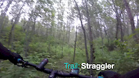
An ode to the Edmonton Stragglers, a long and wandering, physically challenging trail. Careful to stick to the trail and avoid the hiker shortcuts to get the full ride in. Trail entrance is just down from telephone pole on east side of creek and starts with a steep drop in and then climbs back up the bank to circle around natural bowl and under a fallen tree before continuing on along a rooty off camber section before climbing back up to the street level. Pass the bird feeders and stay right, then the trail drops back down to creek level before backtracking and coming back to the top. Continue on the east side of the ridge and drop again to creek level where the trail continues back along the creek before climbing back into the trees and rising up the bank before exiting between the 2 bridges on the main trail. When riding the reverse there is a ride around that bypasses half of the steep climb out.

Local Trail Association

Recent Activity on Trail

Past Week
  • 0 rides
  •  
6 Months
  • 3 rides
  • 4 miles avg distance
All
  • 119 rides
  • Last: Jun 5, 2026
c1c2c3c4
January
February
March
April
May
June
July
August
September
October
November
December
update trails status or condition

Straggler Trail Reports

statusdatedescription
Oct 5, 2025 @ 12:25pm (America/Edmonton)
Oct 5, 2025
larger tree down, head height, across trail section that aligns with the east/west section of Kulawy Dr. can duck underneath without getting off...
Aug 12, 2023 @ 8:58pm
Aug 12, 2023
Sep 5, 2022 @ 7:14pm
Sep 5, 2022
90% of the trail has been cleared of overgrowth. top ridge on the northwest side still to be done
Aug 15, 2022 @ 4:03pm
Aug 15, 2022
great riding conditions although some areas are a bit overgrown still.
Aug 14, 2022 @ 12:19pm
Aug 14, 2022
ridges, hills, and lower creek sections near the bird house section of the trail (middle portion of trail) have been cleared of overgrowth and...
more »
Status:
on Oct 5, 2025
Very Dry
Avg: 4.1 (3 votes)
Your vote: 0

view (840)
close
3D
Trail Conditions
  • Unknown
  • Snow Groomed
  • Snow Packed
  • Snow Covered
  • Snow Cover Partial
  • Freeze/thaw Cycle
  • Icy
  • Prevalent Mud
  • Wet
  • Variable
  • Ideal
  • Dry
  • Very Dry
Trail Flow (Ridden Direction)
Trailforks scans users ridelogs to determine the most popular direction each trail is ridden. A good flowing trail network will have most trails flowing in a single direction according to their intension.
The colour categories are based on what percentage of riders are riding a trail in its intended direction.
  • > 96%
  • > 90%
  • > 80%
  • > 70%
  • > 50%
  • < 50%
  • bi-directional trail
  • no data
Trail Last Ridden
Trailforks scans ridelogs to determine the last time a trail was ridden.
  • < 2 days
  • < 1 week
  • < 2 weeks
  • < 1 month
  • < 6 months
  • > 6 months
Trail Ridden Direction
The intended direction a trail should be ridden.
  • Downhill Only
  • Downhill Primary
  • Both Directions
  • Uphill Primary
  • Uphill Only
  • One Direction
Contribute Details
Colors indicate trail is missing specified detail.
  • Description
  • Photos
  • Description & Photos
  • Videos
Trail Popularity ?
Trailforks scans ridelogs to determine which trails are ridden the most in the last 9 months. Trails are compared with nearby trails in the same city region with a possible 25 colour shades. Think of this as a heatmap, more rides = more kinetic energy = warmer colors.
  • most popular
  • popular
  • less popular
  • not popular
ATV/ORV/OHV Filter
Max Vehicle Width
inches
US Cell Coverage
Legend
cell carrier legend

Radar Time
Activity Recordings
Trailforks uses anonymized public activity data. ?
Activity Recordings
Trailforks uses anonymized public activity data. ?
Personal Heatmap
Activity Types
all / none
Options
2
Date range month
Winter Trails
Warning A routing network for winter maps does not exist. Selecting trails using the winter trails layer has been disabled.
Missing Trails
Most Popular
Least Popular
Trails are colored based on popularity. The more popular a trail is, the more red. Less popular trails trend towards green.
Jump Magnitude Heatmap
Heatmap of where riders jump on trails. Zoom in to see individual jumps, click circles to view jump details.
BC Backroad Status

Service Road Atlas is a free to use, community-driven service for viewing and creating reports on the numerous back-country service roads around B.C. and Alberta.

map legend
Slope Aspect
Direction the slope faces
Flat N NE E SE S SW W NW
Trails Deemphasized
Trails are shown in grey.
disable
Only show trails with no bike usage.
Enable
Suggested Layers
Based on selected activity type

    Save the current map location and zoom level as your default home location whenever this page is loaded.

    Save
        Directions to straggler trailhead (53.470270, -113.406060)

        Photos

        21 more »
        126 |
        Oct 18, 2020 @ 6:37pm
        Oct 18, 2020
        90 |
        Aug 31, 2020 @ 8:21pm
        Aug 31, 2020
        43 |
        Dec 28, 2020 @ 4:40pm
        Dec 28, 2020
        55 |
        Dec 28, 2020 @ 4:38pm
        Dec 28, 2020

        Videos

        2 more »
        Straggler Trail, Sept. 24, 2019
        4:46 | 315 | Sep 25, 2019 , Northwest Edmonton
        Straggler
        9:29 | 128 | Aug 10, 2019 , Northwest Edmonton

        Routes with this trail

        7 miles 140 ft 14
        This route connects majority of the blue trails in this area. Starts at 17th St going west with a...

        3 Reviews & Comments


        We hope you've been enjoying Trailforks!

        Create a FREE account to view trail comments and much more.

        • By cooper24TF Pro & contributors
        • #179730 - 1,318 views

        Frequently Asked Questions About Straggler

        Where is Straggler located?
        Straggler is located in Mill Woods, Northwest Edmonton, Alberta, Canada. It is part of the Mill Woods trail network. The trailhead is located at coordinates 53.47027, -113.40606.
        How hard is Straggler?
        Straggler is rated as Blue difficulty. The average grade is 0.7%. The climb difficulty is rated Blue.
        What is the elevation gain for Straggler?
        Straggler has 22 ft of elevation gain. The trail has 44 ft of elevation descent. The elevation ranges from 2,292 ft to 2,319 ft.
        Is Straggler a point to point trail?
        Straggler is not a point to point trail. The direction is Both Directions. The trail type is singletrack.

        Hit the Trail

        Open in App

        Get this trail on your phone instantly.
        open trail in app

        Download Trail

        Save to wishlist, Garmin & download.
        save the trail

        Find Related Routes

        Find routes and users activities that include this trail.
        find routes for this trail

        You must enter a description before submitting.