more stats
5,023 ft
Distance
-616 ft
Descent
00:06:19
Avg time
-618 ft
Altitude change
588 ft
Altitude min
1,206 ft
Altitude max
1,206 ft
Altitude start
587 ft
Altitude end
-12.3%
Grade
-54.3%
Grade max
-2.5%
Grade min
5,010 ft
Distance down
13 ft
Distance flat
00:06:19
Avg time

Super Maple Details

  • Activities
    • Mountain Bike
    • E-Bike
  • Riding Area
    Thurston Hills Natural Area
    Springfield, Oregon
  • Difficulty Rating
  • Voted Difficulty
    Blue (2 votes)
  • Local Popularity
    75 in Mountain Biking [+]
    • 60 in E-Biking
  • Global Ranking
    #8263 in Mountain Biking
  • Trail Type
    Singletrack
  • Bike Type
    DH, AM, DJ
  • Physical Rating
    Moderate
  • Trail Visibility
    Always easy to follow
  • Season
    Summer/Fall
  • Dogs Allowed
    Yes
  • eBike Allowed
    Yes up to Class 1
  • TTFs on Trail
    Berm, Jump
  • Year Opened
    2022
  • Land Owner
    Willamalane

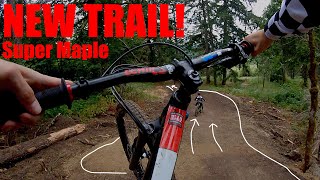
New flow trail built by Kyle Jameson and Black Sage Dirt Works. Trail features high speed berms, and several jumps including table tables, and a step up.

While everything is rollable, please treat the trail like a bike park. Don't ride it alone the first time riding the trail, and pre ride, re ride, and free ride. Some of the table top jumps feature infinity landings, with a landing, a small knuckle and another landing. While this allows riders of different levels and speeds to enjoy the same jump, you don't want to land in the intermediate transition.

Trail Supporters
Local Trail Association

Recent Activity on Trail

Past Week
  • 1 rides
  • 10 miles average
6 Months
  • 21 rides
  • 10 miles avg distance
All
  • 229 rides
  • Last: Jun 19, 2026
c1c2c3c4
January
February
March
April
May
June
July
August
September
October
November
December
Status:
on May 8, 2026
Ideal
Avg: 4.32 (6 votes)
Your vote: 0

view (1,021)
close
3D
Trail Conditions
  • Unknown
  • Snow Groomed
  • Snow Packed
  • Snow Covered
  • Snow Cover Partial
  • Freeze/thaw Cycle
  • Icy
  • Prevalent Mud
  • Wet
  • Variable
  • Ideal
  • Dry
  • Very Dry
Trail Flow (Ridden Direction)
Trailforks scans users ridelogs to determine the most popular direction each trail is ridden. A good flowing trail network will have most trails flowing in a single direction according to their intension.
The colour categories are based on what percentage of riders are riding a trail in its intended direction.
  • > 96%
  • > 90%
  • > 80%
  • > 70%
  • > 50%
  • < 50%
  • bi-directional trail
  • no data
Trail Last Ridden
Trailforks scans ridelogs to determine the last time a trail was ridden.
  • < 2 days
  • < 1 week
  • < 2 weeks
  • < 1 month
  • < 6 months
  • > 6 months
Trail Ridden Direction
The intended direction a trail should be ridden.
  • Downhill Only
  • Downhill Primary
  • Both Directions
  • Uphill Primary
  • Uphill Only
  • One Direction
Contribute Details
Colors indicate trail is missing specified detail.
  • Description
  • Photos
  • Description & Photos
  • Videos
Trail Popularity ?
Trailforks scans ridelogs to determine which trails are ridden the most in the last 9 months. Trails are compared with nearby trails in the same city region with a possible 25 colour shades. Think of this as a heatmap, more rides = more kinetic energy = warmer colors.
  • most popular
  • popular
  • less popular
  • not popular
ATV/ORV/OHV Filter
Max Vehicle Width
inches
US Cell Coverage
Legend
cell carrier legend

Radar Time
Activity Recordings
Trailforks uses anonymized public activity data. ?
Activity Recordings
Trailforks uses anonymized public activity data. ?
Personal Heatmap
Activity Types
all / none
Options
2
Date range month
Winter Trails
Warning A routing network for winter maps does not exist. Selecting trails using the winter trails layer has been disabled.
Missing Trails
Most Popular
Least Popular
Trails are colored based on popularity. The more popular a trail is, the more red. Less popular trails trend towards green.
Jump Magnitude Heatmap
Heatmap of where riders jump on trails. Zoom in to see individual jumps, click circles to view jump details.
BC Backroad Status

Service Road Atlas is a free to use, community-driven service for viewing and creating reports on the numerous back-country service roads around B.C. and Alberta.

map legend
Slope Aspect
Direction the slope faces
Flat N NE E SE S SW W NW
Trails Deemphasized
Trails are shown in grey.
disable
Only show trails with no bike usage.
Enable
Suggested Layers
Based on selected activity type

    Save the current map location and zoom level as your default home location whenever this page is loaded.

    Save
        Directions to super-maple trailhead (44.031570, -122.911130)

        Photos

        4 more »
        134 |
        Oct 3, 2022 @ 12:40pm
        Oct 3, 2022
        149 |
        Sep 7, 2022 @ 5:01pm
        Sep 7, 2022
        156 |
        Sep 7, 2022 @ 5:01pm
        Sep 7, 2022
        221 |
        Jul 1, 2022 @ 9:50pm
        Jul 1, 2022

        Videos

        1 more »
        New Trail!! || Super Maple @ Thurston Hills...
        4:37 | 818 | Jul 15, 2022 , Springfield

        Routes with this trail

        11 miles 2,192 ft 9
        The full tour of Thurston Hills trails (2023) IMPORTANT NOTE: is definitely NOT for beginners (maybe not...
        4 miles 700 ft 3 Out & Back
        is very fun, and well laid out. Manageable for all skill levels. Some rollable doubles and tables, sick...

        8 Reviews & Comments


        We hope you've been enjoying Trailforks!

        Create a FREE account to view trail comments and much more.

        • By BenconomicsTF Pro DOD & contributors
        • #548713 - 2,353 views

        Frequently Asked Questions About Super Maple

        Where is Super Maple located?
        Super Maple is located in Thurston Hills Natural Area, Springfield, Oregon, United States. It is part of the Thurston Hills Natural Area trail network. The trailhead is located at coordinates 44.03157, -122.91113.
        How hard is Super Maple?
        Super Maple is rated as Blue difficulty. The physical rating is Moderate. The average grade is 12.3%.
        What is the elevation gain for Super Maple?
        The trail has 616 ft of elevation descent. The elevation ranges from 588 ft to 1,206 ft.
        How long is Super Maple?
        Super Maple is 5,023 ft long. The trail type is singletrack.

        Hit the Trail

        Open in App

        Get this trail on your phone instantly.
        open trail in app

        Download Trail

        Save to wishlist, Garmin & download.
        save the trail

        Find Related Routes

        Find routes and users activities that include this trail.
        find routes for this trail

        You must enter a description before submitting.