more stats
1.3 miles
Distance
56 ft
Climb
-838 ft
Descent
1 mile
High Point
-782 ft
Altitude change
4,823 ft
Altitude min
5,608 ft
Altitude start
4,826 ft
Altitude end
-11.4%
Grade
-43%
Grade max
14.9%
Grade min
820 ft
Distance climb
1 mile
Distance down
682 ft
Distance flat

TPOC Details

  • Activities
    • Mountain Bike
    • E-Bike
  • Riding Area
    Black Mountain Trail Network
    Nordegg, Alberta
  • Ref Number
    #12
  • Difficulty Rating
  • Local Popularity
    100 in Mountain Biking [+]
    • 100 in E-Biking
  • Global Ranking
    #4080 in Mountain Biking
  • Trail Type
    Machine Groomed
  • Bike Type
    DH, AM, XC, DJ
  • Trail Visibility
    Always easy to follow
  • Dogs Allowed
    Yes
  • eBike Allowed
    Yes up to Class 1
  • TTFs on Trail
    Berm, Drop, Jump, Rock Garden
  • Year Opened
    2024

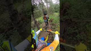
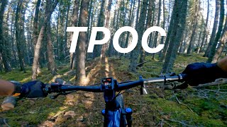
TPOC is a blue rated (More Difficult), tech-flow style trail. Notable trail features include: rollers, berms, and loam.

TPOC stands for: “The Possibilities of Canada Are Truly Great” This slogan originated from the Canadian Gov’t in the early 1900’s, and inspired the title of Martin Nordegg’s autobiography. Just like Canada, Nordegg and this trail offer possibilities you will not want to miss. These range from fast machine groomed sections, big berms, fresh loam, beautiful views and more.

Local Trail Association

Recent Activity on Trail

Past Week
  • 0 rides
  •  
6 Months
  • 5 rides
  • 13.2 km avg distance
All
  • 97 rides
  • Last: Jun 4, 2026
c1c2c3c4
January
February
March
April
May
June
July
August
September
October
November
December
update trails status or condition

TPOC Trail Reports

statusdatedescription
May 15, 2026 @ 6:47pm (America/Edmonton)
May 15, 2026
Trail was inspected and cleared. Variable conditions and some soft spots due to spring like conditions.
Apr 30, 2026 @ 9:24pm (America/Edmonton)
Apr 30, 2026
Walked around the mountain today on a few trails. (Skimmer, Razor Shades, Black Like Velvet, TPOC, Bambi, Makoons, Maskwa, Chaska, Magic Forest....
Dec 9, 2025 @ 9:57pm (America/Edmonton)
Dec 9, 2025
ON DECEMBER 1, 2025 WEST FRASER WILL BEGIN SCHEDULED HARVEST ON BLACK MOUNTAIN. THE GOVERNMENT OF ALBERTA WILL CLOSE ALL TRAILS FOR PUBLIC SAFETY....
Aug 31, 2025 @ 10:50am
Aug 31, 2025
Jul 31, 2025 @ 8:37pm
Jul 31, 2025
more »
Status:
on May 15, 2026
Variable
Avg: 4.09 (5 votes)
Your vote: 0

view (285)
close
3D
Trail Conditions
  • Unknown
  • Snow Groomed
  • Snow Packed
  • Snow Covered
  • Snow Cover Partial
  • Freeze/thaw Cycle
  • Icy
  • Prevalent Mud
  • Wet
  • Variable
  • Ideal
  • Dry
  • Very Dry
Trail Flow (Ridden Direction)
Trailforks scans users ridelogs to determine the most popular direction each trail is ridden. A good flowing trail network will have most trails flowing in a single direction according to their intension.
The colour categories are based on what percentage of riders are riding a trail in its intended direction.
  • > 96%
  • > 90%
  • > 80%
  • > 70%
  • > 50%
  • < 50%
  • bi-directional trail
  • no data
Trail Last Ridden
Trailforks scans ridelogs to determine the last time a trail was ridden.
  • < 2 days
  • < 1 week
  • < 2 weeks
  • < 1 month
  • < 6 months
  • > 6 months
Trail Ridden Direction
The intended direction a trail should be ridden.
  • Downhill Only
  • Downhill Primary
  • Both Directions
  • Uphill Primary
  • Uphill Only
  • One Direction
Contribute Details
Colors indicate trail is missing specified detail.
  • Description
  • Photos
  • Description & Photos
  • Videos
Trail Popularity ?
Trailforks scans ridelogs to determine which trails are ridden the most in the last 9 months. Trails are compared with nearby trails in the same city region with a possible 25 colour shades. Think of this as a heatmap, more rides = more kinetic energy = warmer colors.
  • most popular
  • popular
  • less popular
  • not popular
ATV/ORV/OHV Filter
Max Vehicle Width
inches
US Cell Coverage
Legend
cell carrier legend

Radar Time
Activity Recordings
Trailforks uses anonymized public activity data. ?
Activity Recordings
Trailforks uses anonymized public activity data. ?
Personal Heatmap
Activity Types
all / none
Options
2
Date range month
Winter Trails
Warning A routing network for winter maps does not exist. Selecting trails using the winter trails layer has been disabled.
Missing Trails
Most Popular
Least Popular
Trails are colored based on popularity. The more popular a trail is, the more red. Less popular trails trend towards green.
Jump Magnitude Heatmap
Heatmap of where riders jump on trails. Zoom in to see individual jumps, click circles to view jump details.
BC Backroad Status

Service Road Atlas is a free to use, community-driven service for viewing and creating reports on the numerous back-country service roads around B.C. and Alberta.

map legend
Slope Aspect
Direction the slope faces
Flat N NE E SE S SW W NW
Trails Deemphasized
Trails are shown in grey.
disable
Only show trails with no bike usage.
Enable
Suggested Layers
Based on selected activity type

    Save the current map location and zoom level as your default home location whenever this page is loaded.

    Save
        Directions to tpoc trailhead (52.444290, -116.243650)

        Photos

        7 more »
        137 |
        Oct 10, 2024 @ 8:18pm
        Oct 10, 2024
        139 |
        Oct 10, 2024 @ 8:17pm
        Oct 10, 2024
        127 |
        Oct 10, 2024 @ 8:17pm
        Oct 10, 2024
        153 |
        Oct 10, 2024 @ 8:17pm
        Oct 10, 2024

        Videos

        2 more »
        Black Mountain Trail Network: Chaska to TPOC...
        27:33 | 101 | Aug 13, 2025 , Nordegg
        TPOC - Black Mountain Trail Network
        6:29 | 694 | Oct 17, 2024 , Nordegg

        2 Reviews & Comments


        We hope you've been enjoying Trailforks!

        Create a FREE account to view trail comments and much more.

        • By Macvidal19TF Pro NORCA & contributors
        • #799630 - 802 views

        Frequently Asked Questions About TPOC

        Where is TPOC located?
        TPOC is located in Black Mountain Trail Network, Nordegg, Alberta, Canada. It is part of the Black Mountain Trail Network trail network. The trailhead is located at coordinates 52.44429, -116.24365.
        How hard is TPOC?
        TPOC is rated as Blue difficulty. The average grade is 11.4%.
        What is the elevation gain for TPOC?
        TPOC has 17 m of elevation gain. The trail has 255 m of elevation descent. The elevation ranges from 1,470 m to 1,715 m.
        How long is TPOC?
        TPOC is 2.1 km long. The trail type is machine groomed.

        Hit the Trail

        Open in App

        Get this trail on your phone instantly.
        open trail in app

        Download Trail

        Save to wishlist, Garmin & download.
        save the trail

        Find Related Routes

        Find routes and users activities that include this trail.
        find routes for this trail

        You must enter a description before submitting.