2,590 ft
Distance
143 ft
Climb
-120 ft
Descent
00:13:19
Avg time

Train Wreck Details

  • Activities
    • Mountain Bike
    • Hike
    • Trail Running
  • Riding Area
    Cheakamus
    Whistler, British Columbia
  • Difficulty Rating
  • Trail Type
    Singletrack
  • Bike Type
    AM, XC
  • Direction
    Both Directions
  • Climb Difficulty
    Blue
  • Physical Rating
    Moderate
  • Dogs Allowed
    Yes
  • eBike Allowed
  • TTFs on Trail
    Ladder Bridge, Rock Face, Skinny
  • Ride in Rain
    Yes
  • Global Ranking
    #73043 in Mountain Biking [+]
    • #867 in Trail Running
    • #534 in Hiking
  • Local Popularity
    35 in Mountain Biking [+]
    • 65 in Trail Running
    • 95 in Hiking

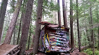
Because the train wreck itself has become popular with sightseers in the last few years the area around the wreck has become a mess of braids and trampled sections of trail. You can access the Trainwreck trail from the new bridge that was installed recently but it will be a challenge finding the proper trail.
The best way to ride Trainwreck is to start on Lower Yer Seat and go South on Trainwreck from the LYS intersection. Then connect to Runaway Train and End Of The Line. Then loop back on the Sea To Sky Trail.
The section of Trainwreck going South from LYS is a newer section built a few years ago so it isn't old school technical like the original Trainwreck. There's still a few elevated bridges and skinny features on the newer section.

Local Trail Association
More Stats for Train Wreck mountain bike trail trail
  • Altitude change
    23 ft
  • Altitude min
    1,831 ft
  • Altitude max
    1,904 ft
  • Altitude start
    1,881 ft
  • Altitude end
    1,904 ft
  • Grade
    0.885%
  • Grade max
    -31.142%
  • Grade min
    32.287%
  • Distance climb
    1,324 ft
  • Distance down
    1,125 ft
  • Distance flat
    141 ft
  • Avg time
    00:13:19
  • Avg reverse time
    00:16:58
  • view trail stats
Status:
on Aug 2, 2023
Dry
Avg: 3 (14 votes)
Your vote: 0

view (866)
close
3D
Trail Conditions
  • Unknown
  • Snow Groomed
  • Snow Packed
  • Snow Covered
  • Snow Cover Inadequate
  • Freeze/thaw Cycle
  • Icy
  • Prevalent Mud
  • Wet
  • Variable
  • Ideal
  • Dry
  • Very Dry
Trail Flow (Ridden Direction)
Trailforks scans users ridelogs to determine the most popular direction each trail is ridden. A good flowing trail network will have most trails flowing in a single direction according to their intension.
The colour categories are based on what percentage of riders are riding a trail in its intended direction.
  • > 96%
  • > 90%
  • > 80%
  • > 70%
  • > 50%
  • < 50%
  • bi-directional trail
  • no data
Trail Last Ridden
Trailforks scans ridelogs to determine the last time a trail was ridden.
  • < 2 days
  • < 1 week
  • < 2 weeks
  • < 1 month
  • < 6 months
  • > 6 months
Trail Ridden Direction
The intended direction a trail should be ridden.
  • Downhill Only
  • Downhill Primary
  • Both Directions
  • Uphill Primary
  • Uphill Only
  • One Direction
Contribute Details
Colors indicate trail is missing specified detail.
  • Description
  • Photos
  • Description & Photos
  • Videos
Trail Popularity ?
Trailforks scans ridelogs to determine which trails are ridden the most in the last 9 months. Trails are compared with nearby trails in the same city region with a possible 25 colour shades. Think of this as a heatmap, more rides = more kinetic energy = warmer colors.
  • most popular
  • popular
  • less popular
  • not popular
ATV/ORV/OHV Filter
Max Vehicle Width
inches

Radar Time
x Activity Recordings
Trailforks users anonymized public ridelogs from the past 6 months.
  • mountain biking recent
  • mountain biking (>6 month)
  • hiking (1 year)
  • moto (1 year)
Activity Recordings
Trailforks users anonymized public skilogs from the past 12 months.
  • Downhill Ski
  • Backcountry Ski
  • Nordic Ski
  • Snowmobile
Winter Trails
Warning A routing network for winter maps does not exist. Selecting trails using the winter trails layer has been disabled.
x Missing Trails
Most Popular
Least Popular
Trails are colored based on popularity. The more popular a trail is, the more red. Less popular trails trend towards green.
Jump Magnitude Heatmap
Heatmap of where riders jump on trails. Zoom in to see individual jumps, click circles to view jump details.
Trails Deemphasized
Trails are shown in grey.
disable
Only show trails with NO bikes.
enable

Save the current map location and zoom level as your default home location whenever this page is loaded.

Save
      Directions to train-wreck trailhead (50.081441, -123.055576)
      update trails status or condition

      Train Wreck Trail Reports

      statusdatedescription
      Aug 2, 2023 @ 7:53pm
      Aug 2, 2023
      reporter
      Apr 13, 2023 @ 1:33pm
      Apr 13, 2023
      No snow. Good to go. Watch for tersts!
      Dec 15, 2022 @ 8:17pm
      Dec 15, 2022
      Oct 16, 2022 @ 2:50pm
      Oct 16, 2022
      reporter
      Cleared the tree
      Oct 10, 2022 @ 3:42am
      Oct 10, 2022
      Small tree down, pictured in previous Sept 13 report. Could get it with a hand saw.
      view all reports »

      Recent Ridelog Activity on Trail

      Past Week
      • 1 rides
      • 23 miles avg distance
      6 Months
      • 42 rides
      • 14 miles avg distance
      All
      • 458 rides
      • Last: Sep 24, 2023

      Photos

      more »
      8 |
      Aug 20, 2023 @ 9:23pm
      Aug 20, 2023
      62 |
      Sep 20, 2020 @ 11:24pm
      Sep 20, 2020
      179 |
      May 21, 2017 @ 12:00am
      May 21, 2017
      357 |
      Sep 17, 2015 @ 10:43pm
      Sep 17, 2015

      Trail Lists

      Trail Products

      7 Reviews & Comments


      We hope you've been enjoying Trailforks!

      Create a FREE account to view trail comments and much more.

      Videos

      more »
      WOW Police and a HUGE WRECK | VANCITY ADVENTURE
      10:53 | 207 | Sep 19, 2020 , Whistler
      WHAT the H*LL Happened? Train Wreck | VANCITY...
      14:42 | 298 | Sep 19, 2020 , Whistler
      Train Wreck
      0:59 | 492 | Aug 25, 2017 , Whistler
      Sketchy Train Wrecking
      0:11 | 1034 | Oct 29, 2015 , Whistler
      • By brenthillier NSMBA TRAILFORKS & contributors
      • #6618 - 12,504 views
      • subscribe
      • flag
      • login to download gpx or kml files.