1.1 miles
Distance
18 ft
Climb
-331 ft
Descent
00:08:58
Avg time
Upper Ed & Flo Details
-
Activities
- Mountain Bike
- E-Bike
- Hike
- Trail Running
-
Riding AreaTwin Buttes
Durango, Colorado -
Difficulty Rating
-
Trail TypeSingletrack
-
DirectionDownhill PrimaryPopular direction shown
-
Dogs AllowedYes
-
eBike AllowedYes up to Class 1
-
TTFs on TrailDrop, Jump
-
Global Ranking
-
Local Popularity100 in Mountain Biking [+]
- 95 in E-Biking
- 85 in Trail Running
- 75 in Hiking
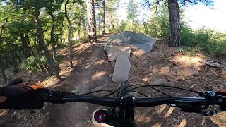
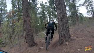
Best flow trail in the Durango Area. Pretty mellow but keep your eyes peeled there are plenty of fun features even an expert can enjoy. E bikes are allowed permanently
Local Trail Association
-
Please consider joining or donating to the local trail association to supportdonate to earn trail karma!
trail development & maintenance.
Traditionally Indigenous Territory
More Stats for Upper Ed & Flo multi-use trail trail
-
Altitude change-315 ft
-
Altitude min7,085 ft
-
Altitude max7,399 ft
-
Altitude start7,399 ft
-
Altitude end7,083 ft
-
Grade-5.4%
-
Grade max-35.9%
-
Grade min10.2%
-
Distance climb636 ft
-
Distance down4,259 ft
-
Distance flat919 ft
-
Avg time00:08:58
-
Avg reverse time00:18:27
- view trail stats
close
3D
Trail Conditions
- Unknown
- Snow Groomed
- Snow Packed
- Snow Covered
- Snow Cover Partial
- Freeze/thaw Cycle
- Icy
- Prevalent Mud
- Wet
- Variable
- Ideal
- Dry
- Very Dry
Trail Flow (Ridden Direction)
Trailforks scans users ridelogs to determine the most popular direction each trail is ridden. A good flowing trail network will have most trails flowing in a single direction according to their intension.
The colour categories are based on what percentage of riders are riding a trail in its intended direction.
- > 96%
- > 90%
- > 80%
- > 70%
- > 50%
- < 50%
- bi-directional trail
- no data
Trail Last Ridden
Trailforks scans ridelogs to determine the last time a trail was ridden.
- < 2 days
- < 1 week
- < 2 weeks
- < 1 month
- < 6 months
- > 6 months
Trail Ridden Direction
The intended direction a trail should be ridden.
- Downhill Only
- Downhill Primary
- Both Directions
- Uphill Primary
- Uphill Only
- One Direction
Contribute Details
Colors indicate trail is missing specified detail.
- Description
- Photos
- Description & Photos
- Videos
Trail Popularity ?
Trailforks scans ridelogs to determine which trails are ridden the most in the last 9 months.
Trails are compared with nearby trails in the same city region with a possible 25 colour shades.
Think of this as a heatmap, more rides = more kinetic energy = warmer colors.
- most popular
- popular
- less popular
- not popular
ATV/ORV/OHV Filter
Max Vehicle Width
inches
US Cell Coverage
Legend
Radar Time
x
Activity Recordings
Trailforks users anonymized public ridelogs from the past 6 months.
- mountain biking recent
- mountain biking (>6 month)
- hiking (1 year)
- moto (1 year)
Activity Recordings
Trailforks users anonymized public skilogs from the past 12 months.
- Downhill Ski
- Backcountry Ski
- Nordic Ski
- Snowmobile
Winter Trails
Warning
A routing network for winter maps does not exist. Selecting trails using the winter trails layer has been disabled.
x
Missing Trails
Most Popular
Least Popular
Trails are colored based on popularity. The more popular a trail is, the more red. Less popular trails trend towards green.
Jump Magnitude Heatmap
Heatmap of where riders jump on trails. Zoom in to see individual jumps, click circles to view jump details.
Trails Deemphasized
Trails are shown in grey.
Only show trails with NO bikes.
Save the current map location and zoom level as your default home location whenever this page is loaded.
Save
Directions to upper-ed--flo trailhead
(37.283630, -107.925820)
update trails status or condition
Upper Ed & Flo Trail Reports
view all reports »
Recent Ridelog Activity on Trail
Past Week
- 0 rides
6 Months
- 110 rides
- 10 miles avg distance
All
- 803 rides
- Last: Oct 31, 2024
Photos
more »
Routes with this trail
Trail Products
We hope you've been enjoying Trailforks!
Create a FREE account to view trail comments and much more.
Videos
more »
youtuber

12:38 |
302 |
Oct 15, 2020 , Durango
Nearby Trails
- Upper Bc And F 0 ft
- Ed & Flo 3,031 ft
- Upper Twin Buttes 3,235 ft
- Twin Buttes Tower Road 4,629 ft
- Lower Loop 4,984 ft
- By todd
Trailforks & contributors
- #13908 - 1,923 views
- follow/subscribe
- login to download gpx or kml files.
You must enter a description before submitting.