1.3 miles
Distance
7 ft
Climb
-849 ft
Descent
00:11:10
Avg time

Verboten Details

  • Activities
    • Mountain Bike
    • E-Bike
    • Hike
    • Trail Running
  • Riding Area
    Mount Fernie Provincial Park
    Fernie, British Columbia
  • Difficulty Rating
  • Trail Type
    Singletrack
  • Direction
    Downhill Only
    Popular direction shown
  • eBike Allowed
    Yes up to Class 1
  • Global Ranking
    #2078 in Mountain Biking [+]
    • #33095 in E-Biking
    • #16253 in Trail Running
    • #34235 in Hiking
  • Local Popularity
    85 in Mountain Biking [+]
    • 85 in E-Biking
    • 70 in Trail Running
    • 55 in Hiking

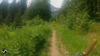
Tricky start with lots of rocks and roots and little drops. The trail opens out and becomes easy and is a great long ride down and back to the Gorby trail.

Great last run to the valley bottom after a day of riding the FAR bike park

Access Info

Head up Gorby Trail and turn right and head about 1,000m up the trail that takes you away from Cedar Bowl. Also accessible if you are riding out of FAR. A steep up in the road is just before the trailhead, and the access road then heads sharply left and down. The trail is just on top of a little mound in front of you before you turn left.

Local Trail Association
Traditionally Indigenous Territory
More Stats for Verboten mountain bike trail trail
  • Altitude change
    -844 ft
  • Altitude min
    3,464 ft
  • Altitude max
    4,307 ft
  • Altitude start
    4,307 ft
  • Altitude end
    3,465 ft
  • Grade
    -12.5%
  • Grade max
    -50.7%
  • Grade min
    7.3%
  • Distance climb
    161 ft
  • Distance down
    1 mile
  • Distance flat
    591 ft
  • Avg time
    00:11:10
  • Avg reverse time
    00:38:47
  • view trail stats
Status:
on Sep 7, 2024
Dry
Avg: 4.66 (35 votes)
Your vote: 0

view (3,013)
close
3D
Trail Conditions
  • Unknown
  • Snow Groomed
  • Snow Packed
  • Snow Covered
  • Snow Cover Partial
  • Freeze/thaw Cycle
  • Icy
  • Prevalent Mud
  • Wet
  • Variable
  • Ideal
  • Dry
  • Very Dry
Trail Flow (Ridden Direction)
Trailforks scans users ridelogs to determine the most popular direction each trail is ridden. A good flowing trail network will have most trails flowing in a single direction according to their intension.
The colour categories are based on what percentage of riders are riding a trail in its intended direction.
  • > 96%
  • > 90%
  • > 80%
  • > 70%
  • > 50%
  • < 50%
  • bi-directional trail
  • no data
Trail Last Ridden
Trailforks scans ridelogs to determine the last time a trail was ridden.
  • < 2 days
  • < 1 week
  • < 2 weeks
  • < 1 month
  • < 6 months
  • > 6 months
Trail Ridden Direction
The intended direction a trail should be ridden.
  • Downhill Only
  • Downhill Primary
  • Both Directions
  • Uphill Primary
  • Uphill Only
  • One Direction
Contribute Details
Colors indicate trail is missing specified detail.
  • Description
  • Photos
  • Description & Photos
  • Videos
Trail Popularity ?
Trailforks scans ridelogs to determine which trails are ridden the most in the last 9 months. Trails are compared with nearby trails in the same city region with a possible 25 colour shades. Think of this as a heatmap, more rides = more kinetic energy = warmer colors.
  • most popular
  • popular
  • less popular
  • not popular
ATV/ORV/OHV Filter
Max Vehicle Width
inches
US Cell Coverage
Legend
cell carrier legend

Radar Time
x Activity Recordings
Trailforks users anonymized public ridelogs from the past 6 months.
  • mountain biking recent
  • mountain biking (>6 month)
  • hiking (1 year)
  • moto (1 year)
Activity Recordings
Trailforks users anonymized public skilogs from the past 12 months.
  • Downhill Ski
  • Backcountry Ski
  • Nordic Ski
  • Snowmobile
Winter Trails
Warning A routing network for winter maps does not exist. Selecting trails using the winter trails layer has been disabled.
x Missing Trails
Most Popular
Least Popular
Trails are colored based on popularity. The more popular a trail is, the more red. Less popular trails trend towards green.
Jump Magnitude Heatmap
Heatmap of where riders jump on trails. Zoom in to see individual jumps, click circles to view jump details.
Trails Deemphasized
Trails are shown in grey.
disable
Only show trails with NO bikes.
enable

Save the current map location and zoom level as your default home location whenever this page is loaded.

Save
      Directions to verboten trailhead (49.478390, -115.122280)
      update trails status or condition

      Verboten Trail Reports

      statusdatedescription
      Sep 7, 2024 @ 10:09am
      Sep 7, 2024
      Aug 19, 2024 @ 9:26am
      Aug 19, 2024
      Aug 10, 2024 @ 5:04am
      Aug 10, 2024
      Jul 18, 2024 @ 11:55am
      Jul 18, 2024
      Deep holes. No trees.
      Jul 13, 2024 @ 7:58am
      Jul 13, 2024
      12 to 14 inch tree down just before last bridge
      view all reports »

      Recent Ridelog Activity on Trail

      Past Week
      • 0 rides
      •  
      6 Months
      • 57 rides
      • 14 miles avg distance
      All
      • 447 rides
      • Last: Oct 18, 2024

      Photos

      more »
      1,067 |
      May 22, 2013 @ 11:08am
      May 22, 2013
      287 |
      Sep 27, 2018 @ 8:15am
      Sep 27, 2018
      322 |
      Sep 27, 2018 @ 8:15am
      Sep 27, 2018
      34 |
      May 20, 2024 @ 7:47pm
      May 20, 2024

      5 Reviews & Comments


      We hope you've been enjoying Trailforks!

      Create a FREE account to view trail comments and much more.

      Videos

      more »
      Redo on Verboten with the chest mount
      6:13 | 509 | Jun 5, 2024 , Fernie
      youtuber Snake Bite & The Forbidden Trail
      12:15 | 458 | Jul 30, 2021 , Fernie
      Verboten - Fernie
      8:14 | 319 | Jul 6, 2021 , Fernie
      youtuber Best Mountain Biking in Fernie, BC - Verboten...
      9:13 | 332 | Dec 17, 2020 , Fernie

      You must enter a description before submitting.