more stats
7.7 miles
Distance
1,559 ft
Climb
-1,574 ft
Descent
01:35:43
Avg time
-15 ft
Altitude change
6,440 ft
Altitude min
7,335 ft
Altitude max
7,226 ft
Altitude start
7,211 ft
Altitude end
-49.2%
Grade max
92%
Grade min
4 miles
Distance climb
3 miles
Distance down
1,608 ft
Distance flat
01:35:43
Avg time

Walker Ranch Loop Details

  • Activities
    • Mountain Bike
    • Hike
    • Trail Running
  • Riding Area
    Walker Ranch
    Boulder, Colorado
  • Difficulty Rating
  • Voted Difficulty
    Blue (8 votes)
  • Local Popularity
    60 in Mountain Biking [+]
    • 65 in Trail Running
    • 80 in Hiking
  • Global Ranking
    #43287 in Mountain Biking [+]
    • #20295 in Trail Running
    • #1996 in Hiking
  • Trail Type
    Singletrack
  • Bike Type
    AM, XC
  • Direction
    Both Directions
  • Climb Difficulty
    Blue
  • Physical Rating
    Hard
  • Dogs Allowed
    Yes
  • eBike Allowed
  • Land Owner

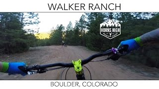
A ride with some of the more rewarding descents in the area although be prepared to work for them. Walker Ranch is most notable for fast loose descents followed by steep leg and lung busting climbs. Be prepared for a mandatory hike-a-bike section as the trail heads down to South Boulder Creek.

Local Trail Association
Traditionally Indigenous Territory

Recent Activity on Trail

Past Week
  • 2 rides
  • 11 miles average
6 Months
  • 27 rides
  • 9 miles avg distance
All
  • 181 rides
  • Last: Jun 15, 2026
c1c2c3c4
January
February
March
April
May
June
July
August
September
October
November
December
update trails status or condition

Walker Ranch Loop Trail Reports

statusdatedescription
Jun 15, 2026 @ 11:56am (America/Denver)
2 days
Feb 9, 2026 @ 8:28pm (America/Denver)
Feb 9, 2026
No snow or ice. Full loop is all dry
Dec 20, 2025 @ 11:47am (America/Denver)
Dec 20, 2025
reporter Trail is open. Please update conditions if you ride
Dec 20, 2025 @ 11:46am (America/Denver)
Dec 20, 2025
reporter Trail is open. Please update conditions if you ride
Dec 18, 2025 @ 9:52pm (America/Denver)
Dec 18, 2025
reporter Trail closed for extreme wind event. Status will be updated when trail reopens
more »
Status:
on Jun 15, 2026
Dry
Avg: 4.03 (22 votes)
Your vote: 0

view (2,054)
close
3D
Trail Conditions
  • Unknown
  • Snow Groomed
  • Snow Packed
  • Snow Covered
  • Snow Cover Partial
  • Freeze/thaw Cycle
  • Icy
  • Prevalent Mud
  • Wet
  • Variable
  • Ideal
  • Dry
  • Very Dry
Trail Flow (Ridden Direction)
Trailforks scans users ridelogs to determine the most popular direction each trail is ridden. A good flowing trail network will have most trails flowing in a single direction according to their intension.
The colour categories are based on what percentage of riders are riding a trail in its intended direction.
  • > 96%
  • > 90%
  • > 80%
  • > 70%
  • > 50%
  • < 50%
  • bi-directional trail
  • no data
Trail Last Ridden
Trailforks scans ridelogs to determine the last time a trail was ridden.
  • < 2 days
  • < 1 week
  • < 2 weeks
  • < 1 month
  • < 6 months
  • > 6 months
Trail Ridden Direction
The intended direction a trail should be ridden.
  • Downhill Only
  • Downhill Primary
  • Both Directions
  • Uphill Primary
  • Uphill Only
  • One Direction
Contribute Details
Colors indicate trail is missing specified detail.
  • Description
  • Photos
  • Description & Photos
  • Videos
Trail Popularity ?
Trailforks scans ridelogs to determine which trails are ridden the most in the last 9 months. Trails are compared with nearby trails in the same city region with a possible 25 colour shades. Think of this as a heatmap, more rides = more kinetic energy = warmer colors.
  • most popular
  • popular
  • less popular
  • not popular
ATV/ORV/OHV Filter
Max Vehicle Width
inches
US Cell Coverage
Legend
cell carrier legend

Radar Time
Activity Recordings
Trailforks uses anonymized public activity data. ?
Activity Recordings
Trailforks uses anonymized public activity data. ?
Personal Heatmap
Activity Types
all / none
Options
2
Date range month
Winter Trails
Warning A routing network for winter maps does not exist. Selecting trails using the winter trails layer has been disabled.
Missing Trails
Most Popular
Least Popular
Trails are colored based on popularity. The more popular a trail is, the more red. Less popular trails trend towards green.
Jump Magnitude Heatmap
Heatmap of where riders jump on trails. Zoom in to see individual jumps, click circles to view jump details.
BC Backroad Status

Service Road Atlas is a free to use, community-driven service for viewing and creating reports on the numerous back-country service roads around B.C. and Alberta.

map legend
Slope Aspect
Direction the slope faces
Flat N NE E SE S SW W NW
Trails Deemphasized
Trails are shown in grey.
disable
Only show trails with no bike usage.
Enable
Suggested Layers
Based on selected activity type

    Save the current map location and zoom level as your default home location whenever this page is loaded.

    Save
        Directions to walker-ranch-loop trailhead (39.951210, -105.337620)

        Photos

        35 more »
        1,090 |
        Mar 9, 2019 @ 7:37am
        Mar 9, 2019
        271 |
        Nov 8, 2023 @ 1:24pm
        Nov 8, 2023
        458 |
        Feb 4, 2021 @ 3:00pm
        Feb 4, 2021
        788 |
        Jul 14, 2020 @ 8:58am
        Jul 14, 2020

        Videos

        7 more »
        youtuber Walker Ranch | Boulder, Colorado | May 2017
        1245 | May 18, 2017 , Boulder
        Walker Ranch Part 2 - Boulder - Colorado
        0:06 | 291 | Nov 15, 2022 , Boulder
        Walker Ranch Loop - Boulder - Colorado
        0:13 | 296 | Nov 11, 2022 , Boulder
        Walker Ranch - Boulder - Colorado -...
        5:33 | 518 | Sep 3, 2021 , Boulder

        Routes with this trail

        3.5 11 miles 2,465 ft 3 Out & Back
        This is an advanced ride, due to steep climbs and lots (and lots and lots) of rocks. Walker Ranch can be...
        No Walker Walker Featured
        15 miles 3,131 ft 1 Out & Back
        The "No Walker Walker" takes the 8 mile long and makes it twice as hard! Instead of doing the full loop,...
        2.0 29 miles 4,875 ft 7 Out & Back
        Oh, Super Walker. Oh Boulder. Walker is an amazing loop! First rate. Black diamond trails with some great...

        12 Reviews & Comments


        We hope you've been enjoying Trailforks!

        Create a FREE account to view trail comments and much more.

        • By toddTF Pro Trailforks & contributors
        • #13693 - 16,889 views

        Frequently Asked Questions About Walker Ranch Loop

        Where is Walker Ranch Loop located?
        Walker Ranch Loop is located in Walker Ranch, Boulder, Colorado, United States. It is part of the Walker Ranch trail network. The trailhead is located at coordinates 39.95121, -105.33762.
        How hard is Walker Ranch Loop?
        Walker Ranch Loop is rated as Black Diamond difficulty. The physical rating is Hard. The climb difficulty is rated Blue.
        What is the elevation gain for Walker Ranch Loop?
        Walker Ranch Loop has 1,559 ft of elevation gain. The trail has 1,574 ft of elevation descent. The elevation ranges from 6,440 ft to 7,335 ft.
        Is Walker Ranch Loop a point to point trail?
        Walker Ranch Loop is not a point to point trail. The direction is Both Directions. The trail type is singletrack.

        Hit the Trail

        Open in App

        Get this trail on your phone instantly.
        open trail in app

        Download Trail

        Save to wishlist, Garmin & download.
        save the trail

        Find Related Routes

        Find routes and users activities that include this trail.
        find routes for this trail

        You must enter a description before submitting.