Z Trail Details
-
Activities
- Mountain Bike
- Hike
- Trail Running
-
Riding AreaHanna Park
Jacksonville, Florida -
Difficulty Rating
-
Voted DifficultyBlue (2 votes)
-
Hiking SAC ScaleT1 Hiking
-
Trail TypeSingletrack
-
Bike TypeAM, XC, Fat
-
DirectionOne Direction
-
Climb DifficultyGreen
-
Physical RatingEasy
-
Trail VisibilitySometimes hard to follow
-
Dogs AllowedYes
-
Global Ranking
-
Local Popularity95 in Mountain Biking [+]
- 5 in Trail Running
- 65 in Hiking
-
Land OwnerJacksonville City
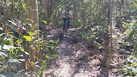
Z Trail is for those who love to test their slow speed balance and technical skills. As the hardest route in Hanna Park, you'll have the book thrown at you.
Tight, twisty sections of singletrack mixed in with quick, punch climbs and descents....this is what you'll find throughout this loop that runs inside of South Loop - Hanna Park
The trail is directional and is ridden clockwise or counter-clockwise depending on the day of the week. It crosses a park road in a couple places, it merges with a green, multi-use trail in one spot and it has a very tight switchback/double-back section at the southern end that can confuse the first time rider.
There are a few bridges and lots of roots to negotiate. There's one tricky wooden feature/bridge concoction that may force a new rider to get off and walk the bike. The bridge is fine, but the wooden feature extending from it doesn't merge naturally with the flow of the trail or the bridge. Most of the trail is tightly packed and smooth, but some portions are sandy and will slow the ride.
Access Info
A fee is required to enter the park.
Local Trail Association
-

-
Please consider joining or donating to the local trail association to supportdonate to earn trail karma!
trail development & maintenance.
More Stats for Z Trail mountain bike trail trail
-
Altitude change0 ft
-
Altitude min5 ft
-
Altitude max9 ft
-
Altitude start9 ft
-
Altitude end10 ft
-
Grade-0%
-
Grade max-1.1%
-
Grade min0.9%
-
Distance climb522 ft
-
Distance down440 ft
-
Distance flat3 miles
-
Avg time00:21:42
-
Avg reverse time00:29:45
- view trail stats
-
Layers w
- Map Content
- More Layers
- Pro
- Pro
- Pro
- Pro
- Pro
- Pro
- Pro
- Pro
-
Upgrade to

- Unknown
- Snow Groomed
- Snow Packed
- Snow Covered
- Snow Cover Partial
- Freeze/thaw Cycle
- Icy
- Prevalent Mud
- Wet
- Variable
- Ideal
- Dry
- Very Dry
The colour categories are based on what percentage of riders are riding a trail in its intended direction.
- > 96%
- > 90%
- > 80%
- > 70%
- > 50%
- < 50%
- bi-directional trail
- no data
- < 2 days
- < 1 week
- < 2 weeks
- < 1 month
- < 6 months
- > 6 months
- Downhill Only
- Downhill Primary
- Both Directions
- Uphill Primary
- Uphill Only
- One Direction
- Description
- Photos
- Description & Photos
- Videos
- most popular
- popular
- less popular
- not popular

- mountain biking recent
- mountain biking (>6 month)
- hiking (1 year)
- moto (1 year)
- Downhill Ski
- Backcountry Ski
- Nordic Ski
- Snowmobile
Save the current map location and zoom level as your default home location whenever this page is loaded.
SaveZ Trail Trail Reports
Recent Ridelog Activity on Trail
- 13 rides
- 14 miles avg distance
- 263 rides
- 15 miles avg distance
- 2,613 rides
- Last: May 19, 2024
Photos
5 Reviews & Comments
We hope you've been enjoying Trailforks!
Create a FREE account to view trail comments and much more.
Videos
Nearby Trails
- South Loop 102 ft
- E-line Connector 758 ft
- Access Rd 1,860 ft
- E-line Loop 2,461 ft
- Multiuse 2,461 ft
- By brenthillier
 NSMBA TRAILFORKS & contributors
 - #4542 - 2,869 views
- follow/subscribe
- login to download gpx or kml files.
You must enter a description before submitting.