more stats
1.5 miles
Distance
-548 ft
Descent
00:07:53
Avg time
-548 ft
Altitude change
5,667 ft
Altitude min
6,215 ft
Altitude max
6,215 ft
Altitude start
5,666 ft
Altitude end
-6.9%
Grade
-31.8%
Grade max
26 ft
Distance climb
1 mile
Distance down
125 ft
Distance flat
00:07:53
Avg time

Zooropa Details

  • Activities
    • Mountain Bike
    • E-Bike
  • Riding Area
    Corner Canyon
    Draper, Utah
  • Difficulty Rating
  • Voted Difficulty
    Blue (6 votes)
  • Local Popularity
    90 in Mountain Biking [+]
    • 100 in E-Biking
  • Global Ranking
    #1139 in Mountain Biking [+]
    • #1562 in E-Biking
  • Trail Type
    Singletrack
  • Bike Type
    DH, AM, XC
  • Direction
    Downhill Only
    Popular Direction Shown
  • Climb Difficulty
    Black Diamond
  • Physical Rating
    Moderate
  • Trail Visibility
    Always easy to follow
  • Dogs Allowed
    Yes
  • eBike Allowed
    Yes up to Class 1
  • TTFs on Trail
    Berm, Jump
  • Land Owner
    Draper City Trails and Open Spaces

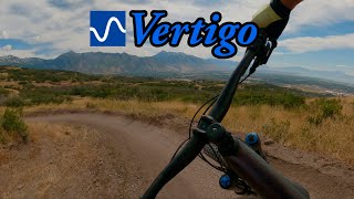
A masterful addition to the already popular south slope downhill trails. This trail has been rebuilt and has just re-opened (June 2024). It is awesome; the uphill part is gone, and it now starts at the same place as Levitate and Vertigo. The trail flows well, with pedaling optional. It has creative jumps and angled lips/transitions that can be sent on the small side for the intermediates, and on the big side for the advanced jumpers. It has Huge berms that alternate throwing you back and forth. The trail cuts back and takes you on a roller coaster ride of small to medium size table tops right after fast berms. Beginners can start on Rattle and Hum & work up to Vertigo. After mastering Vertigo, this trail is a great stepping stone to progress jumping skills to advance to Levitate.

Trail Supporters
Local Trail Association
Traditionally Indigenous Territory

Recent Activity on Trail

Past Week
  • 50 rides
  • 13 miles average
6 Months
  • 489 rides
  • 12 miles avg distance
All
  • 2,784 rides
  • Last: Jul 4, 2026
c1c2c3c4
January
February
March
April
May
June
July
August
September
October
November
December
Status:
on Jun 13, 2026
Dry
Avg: 4.04 (74 votes)
Your vote: 0

view (18,231)
close
3D
Trail Conditions
  • Unknown
  • Snow Groomed
  • Snow Packed
  • Snow Covered
  • Snow Cover Partial
  • Freeze/thaw Cycle
  • Icy
  • Prevalent Mud
  • Wet
  • Variable
  • Ideal
  • Dry
  • Very Dry
Trail Flow (Ridden Direction)
Trailforks scans users ridelogs to determine the most popular direction each trail is ridden. A good flowing trail network will have most trails flowing in a single direction according to their intension.
The colour categories are based on what percentage of riders are riding a trail in its intended direction.
  • > 96%
  • > 90%
  • > 80%
  • > 70%
  • > 50%
  • < 50%
  • bi-directional trail
  • no data
Trail Last Ridden
Trailforks scans ridelogs to determine the last time a trail was ridden.
  • < 2 days
  • < 1 week
  • < 2 weeks
  • < 1 month
  • < 6 months
  • > 6 months
Trail Ridden Direction
The intended direction a trail should be ridden.
  • Downhill Only
  • Downhill Primary
  • Both Directions
  • Uphill Primary
  • Uphill Only
  • One Direction
Contribute Details
Colors indicate trail is missing specified detail.
  • Description
  • Photos
  • Description & Photos
  • Videos
Trail Popularity ?
Trailforks scans ridelogs to determine which trails are ridden the most in the last 9 months. Trails are compared with nearby trails in the same city region with a possible 25 colour shades. Think of this as a heatmap, more rides = more kinetic energy = warmer colors.
  • most popular
  • popular
  • less popular
  • not popular
ATV/ORV/OHV Filter
Max Vehicle Width
inches
US Cell Coverage
Legend
cell carrier legend

Radar Time
Activity Recordings
Trailforks uses anonymized public activity data. ?
Activity Recordings
Trailforks uses anonymized public activity data. ?
Personal Heatmap
Activity Types
all / none
Options
2
Date range month
Winter Trails
Warning A routing network for winter maps does not exist. Selecting trails using the winter trails layer has been disabled.
Missing Trails
Most Popular
Least Popular
Trails are colored based on popularity. The more popular a trail is, the more red. Less popular trails trend towards green.
Jump Magnitude Heatmap
Heatmap of where riders jump on trails. Zoom in to see individual jumps, click circles to view jump details.
BC Backroad Status

Service Road Atlas is a free to use, community-driven service for viewing and creating reports on the numerous back-country service roads around B.C. and Alberta.

map legend
Slope Aspect
Direction the slope faces
Flat N NE E SE S SW W NW
Trails Deemphasized
Trails are shown in grey.
disable
Only show trails with no bike usage.
Enable
Suggested Layers
Based on selected activity type

    Save the current map location and zoom level as your default home location whenever this page is loaded.

    Save
        Directions to zooropa trailhead (40.472490, -111.837640)

        Photos

        10 more »
        491 |
        Jun 1, 2018 @ 7:48pm
        Jun 1, 2018
        491 |
        Jun 8, 2018 @ 9:59pm
        Jun 8, 2018
        434 |
        Jun 8, 2018 @ 9:59pm
        Jun 8, 2018
        418 |
        Jun 8, 2018 @ 9:59pm
        Jun 8, 2018

        Videos

        6 more »
        youtuber Zooropa Trail | New Trail Day!  | Happy...
        6:54 | 1973 | May 31, 2018 , Draper
        Epic Sunset Ride in Salt Lake City | MTB Road...
        24:49 | 78 | Mar 28, 2026 , Draper
        Zooropa - Corner Canyon, UT - 4/22/2025
        4:32 | 209 | Apr 22, 2025 , Draper
        youtuber Vertigo and Zooropa
        7:51 | 270 | Sep 26, 2023 , Draper

        Routes with this trail

        29 miles 5,153 ft 28
        Church of Dirt route for Wheelie Spoked ride in Corner Canyon.
        2.5 21 miles 3,021 ft 18 Loop
        This route hits the primary downhill trails on the south side of corner canyon (Levitate, Vertigo, Achtung...
        24 miles 4,312 ft 18 Loop
        Connect the South side of Canyon Canyon with the North side of Corner Canyon and Traverse Mountain, one...

        42 Reviews & Comments


        We hope you've been enjoying Trailforks!

        Create a FREE account to view trail comments and much more.

        • By toddTF Pro Trailforks & contributors
        • #132119 - 11,933 views

        Frequently Asked Questions About Zooropa

        Where is Zooropa located?
        Zooropa is located in Corner Canyon, Draper, Utah, United States. It is part of the Corner Canyon trail network. The trailhead is located at coordinates 40.47249, -111.83764.
        How hard is Zooropa?
        Zooropa is rated as Blue difficulty. The physical rating is Moderate. The average grade is 6.9%. The climb difficulty is rated Black Diamond.
        What is the elevation gain for Zooropa?
        The trail has 548 ft of elevation descent. The elevation ranges from 5,667 ft to 6,215 ft.
        Is Zooropa a point to point trail?
        Yes, Zooropa is a point to point trail. The direction is Downhill Only. The trail type is singletrack.

        Hit the Trail

        Open in App

        Get this trail on your phone instantly.
        open trail in app

        Download Trail

        Save to wishlist, Garmin & download.
        save the trail

        Find Related Routes

        Find routes and users activities that include this trail.
        find routes for this trail

        You must enter a description before submitting.