Sedona Red Rock Trail Fund
| Type | Trail Association |
|---|---|
| Activities |
|
| Website |
| Geo | |
|---|---|
| Address |
Sedona,
Arizona
86340
United States

|
| Associated Group |
SRRTF Sedona Red Rock Trail Fund
|
3
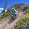
We are a coalition of hikers, bikers, equestrians and outdoor enthusiasts who believe that the trails that connect us to the adventure and beauty of the Red Rock are worth caring for. Funds raised by our organization provide direct support to the US Forest Service to facilitate establishment and maintenance of trails within the spectacular Red Rock Ranger District.
Riding Areas
| name | trails | total descent | highest trail | total distance |
|---|---|---|---|---|
| Bell Rock | 17 | -1,146 ft | 4,804 ft | 13 miles |
| Broken Arrow | 22 | -2,898 ft | 4,769 ft | 16 miles |
| Carroll Canyon | 19 | -3,541 ft | 4,806 ft | 19 miles |
| Schnebly Hill | 18 | -8,842 ft | 1 mile | 40 miles |
| Soldier Wash | 29 | -3,409 ft | 1 mile | 24 miles |
| Turkey Creek | 18 | -2,318 ft | 4,776 ft | 17 miles |
| Upper Dry Creek | 51 | -7,087 ft | 1 mile | 72 miles |
Earn Trail Karma by Donating to the Local Trail Association
Help fund trail maintenance and development
Donate