close
-
Layers w
- Weather Layers
- Pro
- Pro
- Pro
- Pro
- Pro
- Pro
- More Layers
- Pro
- Pro
- Pro
- Pro
-
Upgrade to

3D
Trail Conditions
- Unknown
- Snow Groomed
- Snow Packed
- Snow Covered
- Snow Cover Partial
- Freeze/thaw Cycle
- Icy
- Prevalent Mud
- Wet
- Variable
- Ideal
- Dry
- Very Dry
Trail Flow (Ridden Direction)
Trailforks scans users ridelogs to determine the most popular direction each trail is ridden. A good flowing trail network will have most trails flowing in a single direction according to their intension.
The colour categories are based on what percentage of riders are riding a trail in its intended direction.
The colour categories are based on what percentage of riders are riding a trail in its intended direction.
- > 96%
- > 90%
- > 80%
- > 70%
- > 50%
- < 50%
- bi-directional trail
- no data
Trail Last Ridden
Trailforks scans ridelogs to determine the last time a trail was ridden.
- < 2 days
- < 1 week
- < 2 weeks
- < 1 month
- < 6 months
- > 6 months
Trail Ridden Direction
The intended direction a trail should be ridden.
- Downhill Only
- Downhill Primary
- Both Directions
- Uphill Primary
- Uphill Only
- One Direction
Contribute Details
Colors indicate trail is missing specified detail.
- Description
- Photos
- Description & Photos
- Videos
Trail Popularity ?
Trailforks scans ridelogs to determine which trails are ridden the most in the last 9 months.
Trails are compared with nearby trails in the same city region with a possible 25 colour shades.
Think of this as a heatmap, more rides = more kinetic energy = warmer colors.
- most popular
- popular
- less popular
- not popular
ATV/ORV/OHV Filter
Max Vehicle Width
inches
US Cell Coverage
Legend

Radar Time
Activity Recordings
Trailforks uses anonymized public activity data.
?
Activity Recordings
Trailforks uses anonymized public activity data.
?
Personal Heatmap
▶
Activity Types
all
/
none
▶
Options
2
Date range
month
–
Winter Trails
Warning
A routing network for winter maps does not exist. Selecting trails using the winter trails layer has been disabled.
Missing Trails
Most Popular
Least Popular
Trails are colored based on popularity. The more popular a trail is, the more red. Less popular trails trend towards green.
Jump Magnitude Heatmap
Heatmap of where riders jump on trails. Zoom in to see individual jumps, click circles to view jump details.
BC Backroad Status
![map legend]()
Service Road Atlas is a free to use, community-driven service for viewing and creating reports on the numerous back-country service roads around B.C. and Alberta.

Slope Aspect
Direction the slope faces
Trails Deemphasized
Trails are shown in grey.
Only show trails with no bike usage.
Suggested Layers
Based on selected activity type
Save the current map location and zoom level as your default home location whenever this page is loaded.
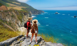
SaveThe City of Bishop is a small city in the spectacular Eastern Sierra region of California. The Eastern Sierra region is about the middle of the state along its eastern border with Nevada and about halfway between Yosemite and Death Valley National Parks. Bishop – originally called Bishop Creek – is located on the eastern slopes of the Sierra Nevada along the banks of the creek that is its namesake. Bishop sits at an elevation of about 4,100 feet while just a few miles away in either direction peaks tower to 14,000 feet, giving Bishop a truly spectacular setting. Bishop is a small city with a big back yard
Links
Activities Click to view
- Mountain Bike
123 trails
- E-Bike
45 trails
- Gravel Bike
0 trails
- Adaptive Bike
0 trails
- Winter Fat Bike
0 trails
- Horse
64 trails
- Hike
181 trails
- Trail Running
179 trails
- Dirtbike/Moto
27 trails
- ATV/ORV/OHV
17 trails
- Snowmobile
4 trails
- Snowshoe
4 trails
Region Details
- 25
- 22
- 38
- 27
- 7
Region Status
Caution as of Jun 6, 2026Stats
- Avg Trail Rating
- Trails (view details)
- 179
- Trails Mountain Bike
- 123
- Trails E-Bike
- 45
- Trails Horse
- 64
- Trails Hike
- 181
- Trails Trail Running
- 179
- Trails Dirtbike/Moto
- 27
- Trails Observed Trials
- 1
- Trails ATV/ORV/OHV
- 17
- Trails Snowmobile
- 4
- Trails Snowshoe
- 4
- Trails Backcountry Ski
- 1
- Total Distance
- 516 miles
- Total Descent
- 110,014 ft
- Total Vertical
- 10,218 ft
- Highest Trailhead
- 14,247 ft
- Reports
- 175
- Photos
- 163
- Ridden Counter
- 5,041
Articles
Wanna Hike in California? These Are the 13 Most Stunning Trails.
Jul 18, 2024 from outsideonline.com
A longtime Golden State hiker reveals her dream list of the most beautiful, must-see routes in California
Sub Regions
-
Ancient Bristlecone Pine Forest
- 1
-
Bishop Area Trails
- 17
- 7
- 11
- 1
Popular Bishop Mountain Biking Trails
• 100 ★ 4.5 • 8 miles • 30 ft • 561 •
One of the area's best singletrack trails with a few ride options from a longer out and back, shuttle, or a lap or two on the upper sections for a quick fix. The trail is in somewhat sandy substrate so running a lower tire pressure is...
• 100 ★ 1.0 • 1,640 ft • 0 ft • 132 •
One of may identical-looking sagebrush single track downhills.
• 75 ★ 4.3 • 2 miles • 1,071 ft • 68 •
Great alternative to riding up Rd for the full loop. Look for the old corral adjacent to the switchback immediately after the fire station.
• 80 ★ 4.7 • 4 miles • 409 ft • 68 •
is a fun single track descent out of the white mountains, that twists through washes, drops over dry falls through a fun canyon section, and offers awesome views of the Sierra throughout.
• 95 ★ 1.0 • 3,094 ft • 0 ft • 66 •
Popular green difficulty singletrack. This mountain bike primary trail can be used both directions. On average it takes 2 minutes to complete this trail.
• 90 ★ 3.0 • 1,906 ft • 0 ft • 65 •
Somewhat flows trail through a wash. Two of the roller/jumps are easy to launch to flat, the step up at the end pops you over a steel pipe that you’ll want to clear.
• 90 ★ 4.4 • 3,970 ft • 289 ft • 62 •
Starts by rolling over a large rock slab then into a small rocky drop/turn, a few optional drops as you continue down the bench cut trail which leads to a flatter section with optional rock roll/drops that you may wanna look at before...
Bishop Mountain Bike Routes
★ 5.0 • 27 miles • 3,231 ft • 3 • Shuttled •
June-September Eastern Sierra Transit offers a shuttle for $5 from Bishop to South Lake:...
★ 5.0 • 19 miles • 4,567 ft • 6 • Loop •
A difficult alpine loop with a long doubletrack climb that takes you above tree line, a couple ups and...
★ 5.0 • 13 miles • 1,156 ft • 9 • Shuttled •
This is sort of the classic descent for . If you're not up for the steep descent of , continue on the main...
14 miles • 1,019 ft • 1 • Loop •
Fun loop from Downtown Bishop. Climbing is mostly moderate with a few hard steep sections. Amazing views...
★ 5.0 • 32 miles • 6,872 ft • 9 • Loop •
A long big mountain loop in the White Mountains, with a long punishing climb, and a variety of fun and...
0 • Point to Point •
Road is very sandy and loose. Be prepared for semi-deep sand and rocky 4x4 roads. Amazing views and the...
Photos of Bishop Mountain Bike
Videos of Bishop Mountain Bike
trail: Pet Cemetery
0:15 |
|
May 21, 2021
youtuber
![Poleta Canyon / Bishop, CA / MTB]()
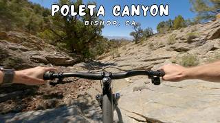
trail: Poleta Canyon
4:44 |
19 |
May 20, 2026 , Bishop
youtuber
![Poleta Ridge / Bishop, CA / MTB]()
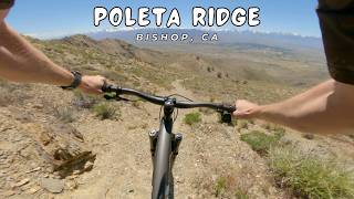
trail: Poleta Ridge
8:48 |
36 |
May 14, 2026 , Bishop
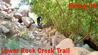
trail: Lower Rock Creek
9:25 |
103 |
Jun 29, 2025 , Bishop
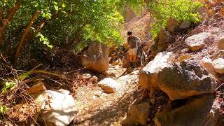
trail: Lower Rock Creek
0:30 |
125 |
Oct 24, 2024 , Bishop

trail: Insane Assylum
15:52 |
124 |
Dec 25, 2023 , Bishop

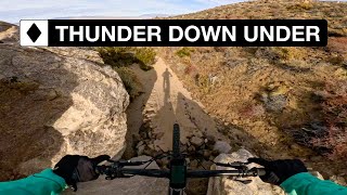
trail: Thunder Down Under
15:52 |
156 |
Dec 25, 2023 , Bishop
trail: High Line
15:52 |
206 |
Dec 25, 2023 , Bishop
Current Trail Warnings
| status | trail | date | condition | user | info |
|---|---|---|---|---|---|
| Black Canyon Road | Jun 4, 2026 @ 6:04am (America/Los_Angeles) Jun 4, 2026 | Wet | rickinlo | Better than it was but still not great.... |
Recent Trail Reports
| status | trail | date | condition | info | user |
|---|---|---|---|---|---|
| Rusty Bike | May 29, 2026 @ 12:14pm (America/Los_Angeles) May 29, 2026 | Dry | chilewings | ||
| Landing Strip - up | May 29, 2026 @ 12:14pm (America/Los_Angeles) May 29, 2026 | Dry | chilewings | ||
| Zymarikaphobia | May 29, 2026 @ 12:14pm (America/Los_Angeles) May 29, 2026 | Unknown | chilewings | ||
| Coulrophobia | May 29, 2026 @ 12:14pm (America/Los_Angeles) May 29, 2026 | Unknown | chilewings | ||
| Insane Assylum | May 29, 2026 @ 12:14pm (America/Los_Angeles) May 29, 2026 | Dry | chilewings | ||
| High Line | May 29, 2026 @ 12:14pm (America/Los_Angeles) May 29, 2026 | Unknown | chilewings | ||
| Big Guy Bigger Ego | May 1, 2026 @ 11:45am (America/Los_Angeles) May 1, 2026 | Dry | rickinlo | ||
| Blue Bulls Rampage | May 1, 2026 @ 11:45am (America/Los_Angeles) May 1, 2026 | Dry | rickinlo | ||
| Rusty Box Spring | May 1, 2026 @ 11:45am (America/Los_Angeles) May 1, 2026 | Dry | rickinlo | ||
| No Dabs | May 1, 2026 @ 11:45am (America/Los_Angeles) May 1, 2026 | Dry | rickinlo |
Activity Feed
| username | action | type | title | date |
|---|---|---|---|---|
| Megan6yWTFy | wishlist | trail | activity #96518485 | Jun 7, 2026 @ 8:31pm Jun 7, 2026 |
| Megan6yWTFy | add | report | activity #96431629 | Jun 6, 2026 @ 10:38pm Jun 6, 2026 |
| blodh | wishlist | trail | activity #96274623 and 1 more | Jun 4, 2026 @ 8:40pm Jun 4, 2026 |
| rickinlo | add | report | activity #96254717 | Jun 4, 2026 @ 3:12pm Jun 4, 2026 |
| scxsKqV0 | wishlist | trail | activity #95541585 and 1 more | May 25, 2026 @ 8:35pm May 25, 2026 |
Recent Comments
| username | type | title | comment | date |
|---|---|---|---|---|
| trail | If you like flow, berms, and a little bit of... | Apr 16, 2026 @ 10:21am Apr 16, 2026 | ||
| trail | Fun ride minus the over grown bushes and sand.... | Apr 16, 2026 @ 10:10am Apr 16, 2026 | ||
| trail | The top of this trail is fun and fast through... | Apr 16, 2026 @ 10:06am Apr 16, 2026 | ||
| trail | Fun area, but it’s very easy to get on the... | Apr 8, 2026 @ 2:32pm Apr 8, 2026 | ||
| trail | 1st section is fun and long through the trees.... | Apr 8, 2026 @ 7:36am Apr 8, 2026 |
Local Badges
-

10 Blue Trails29 awarded -

Epic Ride Climb 2k61 awarded -

Climbing 10k Badge28 awarded -

Climbing 100k Badge2 awarded -

Epic Ride Descent 2k118 awarded -

Descent 10k Badge32 awarded
Bike & Skill Parks
| name | type | city | rating |
|---|---|---|---|
| Bishop Bike Park | skill park | Bishop | |
| Bishop Moto Park | skill park | Bishop | |
| Bishop MX | skill park | Bishop |
Activity Type Stats
| activitytype | trails | distance | descent | descent distance | total vertical | rating | global rank | state rank | photos | reports | routes | ridelogs |
|---|---|---|---|---|---|---|---|---|---|---|---|---|
| Mountain Bike | 123 | 369 miles | 88,133 ft | 173 miles | 10,217 ft | #585 | #217 | 137 | 174 | 7 | 8,149 | |
| E-Bike | 45 | 152 miles | 29,816 ft | 62 miles | 8,940 ft | #949 | #783 | 128 | 1 | 289 | ||
| Horse | 64 | 190 miles | 32,989 ft | 74 miles | 8,852 ft | #129 | #384 | 30 | 1 | |||
| Hike | 181 | 514 miles | 109,570 ft | 219 miles | 10,217 ft | #110 | #65 | 28 | 174 | 4 | 2,796 | |
| Trail Running | 179 | 511 miles | 107,566 ft | 216 miles | 10,217 ft | #168 | #74 | 174 | 3 | 500 | ||
| Dirtbike/Moto | 27 | 127 miles | 22,336 ft | 53 miles | 7,549 ft | #204 | #117 | 31 | 10 | |||
| Observed Trials | 1 | 7 miles | 1,286 ft | 6 miles | 1,188 ft | 3 | ||||||
| ATV/ORV/OHV | 17 | 101 miles | 14,662 ft | 35 miles | 7,526 ft | #181 | #76 | 29 | 1 | 2 | ||
| Snowmobile | 4 | 19 miles | 7,241 ft | 12 miles | 6,027 ft | #189 | #86 | |||||
| Snowshoe | 4 | 19 miles | 7,241 ft | 12 miles | 6,027 ft | #520 | #189 | 7 | ||||
| Backcountry Ski | 1 | 7 miles | 1,286 ft | 6 miles | 1,188 ft | 1 | 155 |
Frequently Asked Questions About Bishop
▼
What are the best places to ride in Bishop?
Bishop has 2 areas to explore for mountain biking. The top rated areas are:
▼
What are the highest rated mountain biking trails in Bishop?
The highest rated mountain biking trails in Bishop are:
- Lower Rock Creek (4.3/5)
- Upper Rock Creek Canyon (4.2/5)
- South Branch of Poleta (4.2/5)
- E-Ticket (4.2/5)
- Poleta Canyon (4.2/5)
▼
What is the best time of the year to ride in Bishop?
Based on ride log data, the most popular months to ride in Bishop are:
- May (33 activities)
- November (31 activities)
- June (23 activities)
▼
Where can I park to ride in Bishop?
There are 18 parking locations listed in Bishop. The most popular parking spots are: View all parking and trailhead locations on the map to plan your visit.
Activities
Trails
Points of Interest
- Willow Campground Camping
- Big Pine Creek Campground Camping
- Upper Sage Flat Campground Camping
- Sage Flat Campground Camping
- Mosquito Flats Campground Camping
- North Lake Campground Camping
- Bishop Pass Summit
- Mount Emerson Summit
- Koip Peak Summit
- North Palisade (4,348 m)
- White Mountain Peak (4,343 m)
- Mount Sill (4,306 m)
- By aoneal & contributors
- Admins: TheAngryTomato
- #8536 - 17,324 views
- bishop activity log | embed map of Bishop mountain bike trails | bishop mountain biking points of interest
Downloading of trail gps tracks in kml & gpx formats is enabled for Bishop.
You must login to download files.