close
-
Layers w
- Weather Layers
- Pro
- Pro
- Pro
- Pro
- Pro
- Pro
- More Layers
- Pro
- Pro
- Pro
- Pro
-
Upgrade to

3D
Trail Conditions
- Unknown
- Snow Groomed
- Snow Packed
- Snow Covered
- Snow Cover Partial
- Freeze/thaw Cycle
- Icy
- Prevalent Mud
- Wet
- Variable
- Ideal
- Dry
- Very Dry
Trail Flow (Ridden Direction)
Trailforks scans users ridelogs to determine the most popular direction each trail is ridden. A good flowing trail network will have most trails flowing in a single direction according to their intension.
The colour categories are based on what percentage of riders are riding a trail in its intended direction.
The colour categories are based on what percentage of riders are riding a trail in its intended direction.
- > 96%
- > 90%
- > 80%
- > 70%
- > 50%
- < 50%
- bi-directional trail
- no data
Trail Last Ridden
Trailforks scans ridelogs to determine the last time a trail was ridden.
- < 2 days
- < 1 week
- < 2 weeks
- < 1 month
- < 6 months
- > 6 months
Trail Ridden Direction
The intended direction a trail should be ridden.
- Downhill Only
- Downhill Primary
- Both Directions
- Uphill Primary
- Uphill Only
- One Direction
Contribute Details
Colors indicate trail is missing specified detail.
- Description
- Photos
- Description & Photos
- Videos
Trail Popularity ?
Trailforks scans ridelogs to determine which trails are ridden the most in the last 9 months.
Trails are compared with nearby trails in the same city region with a possible 25 colour shades.
Think of this as a heatmap, more rides = more kinetic energy = warmer colors.
- most popular
- popular
- less popular
- not popular
ATV/ORV/OHV Filter
Max Vehicle Width
inches
US Cell Coverage
Legend

Radar Time
Activity Recordings
Trailforks uses anonymized public activity data.
?
Activity Recordings
Trailforks uses anonymized public activity data.
?
Personal Heatmap
▶
Activity Types
all
/
none
▶
Options
2
Date range
month
–
Winter Trails
Warning
A routing network for winter maps does not exist. Selecting trails using the winter trails layer has been disabled.
Missing Trails
Most Popular
Least Popular
Trails are colored based on popularity. The more popular a trail is, the more red. Less popular trails trend towards green.
Jump Magnitude Heatmap
Heatmap of where riders jump on trails. Zoom in to see individual jumps, click circles to view jump details.
BC Backroad Status
![map legend]()
Service Road Atlas is a free to use, community-driven service for viewing and creating reports on the numerous back-country service roads around B.C. and Alberta.

Slope Aspect
Direction the slope faces
Trails Deemphasized
Trails are shown in grey.
Only show trails with no bike usage.
Suggested Layers
Based on selected activity type
Save the current map location and zoom level as your default home location whenever this page is loaded.
Save
No description for Davos has been added yet!
Login or register to submit one.
AKA: Klosters
This region uses the Uk/Euro style trail grading system.
Activities Click to view
- Mountain Bike
207 trails
- E-Bike
198 trails
- Gravel Bike
5 trails
- Adaptive Bike
4 trails
- Hike
210 trails
- Trail Running
212 trails
- Snowshoe
0 trails
- Downhill Ski
0 trails
- Backcountry Ski
3 trails
- Nordic Ski
0 trails
Region Details
- 47
- 20
- 45
- 74
- 17
Region Status
Open as of 13 hoursLocal Trail Association
Stats
- Avg Trail Rating
- Trails (view details)
- 215
- Trails Mountain Bike
- 207
- Trails E-Bike
- 198
- Trails Gravel Bike
- 5
- Trails Adaptive Bike
- 4
- Trails Hike
- 212
- Trails Trail Running
- 212
- Trails Backcountry Ski
- 3
- Total Distance
- 273 miles
- Total Descent
- 116,726 ft
- Total Vertical
- 6,309 ft
- Highest Trailhead
- 8,960 ft
- Reports
- 6,504
- Photos
- 703
- Ridden Counter
- 56,717
Articles
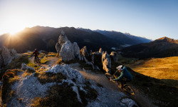
Photo Story: Trails and Views in Davos
Nov 20, 2023 from pinkbike.com
Sub Regions
-
Davos Klosters
- 20
- 45
- 74
- 17
Popular Davos Mountain Biking Trails
• 75 ★ 4.6 • 5 miles • 825 ft • 1,664 •
Vom Strelapass führt ein schöner Singletrail weiter über die Latschüelfurgga zur Chörbschhornhütte. Wer noch nicht genug hat steigt zu Fuss hoch zum Chörbschhorngipfel. Von der Chörbschhornhütte folgt das Highlight des Trails....
• 100 ★ 4.7 • 3 miles • 3 ft • 1,327 •
Die Strecke wurde 2015 von der Trail Crew saniert. Dies ist der erste Teil des Alps Epic Trail Davos. Der Startpunkt kann bequem mit der erreicht werden. Bitte aus Rücksicht auf unsere Wildtiere diesen Trail zwischen 18:30 und 08:00...
• 100 ★ 4.4 • 1 mile • 10 ft • 1,089 •
Biker-Strecke (kein Durchgang für Fussgänger) mit viel Tempo, einigen Wellen (Sprünge möglich) und Anlegerkurven. Bitte aus Rücksicht auf unsere Wildtiere diesen Trail zwischen 18:30 und 08:00 Uhr nicht befahren. Danke fürs...
• 90 ★ 4.8 • 1 mile • 3 ft • 939 •
The top Part is flowy Singletrack with a stunning view over the Silvretta glacier and also lake of Davos. The middle Section is very rocky and steep, so you have to be ready and trust in your skills! Ober Singletrack mit Atemberaubender...
• 85 ★ 3.8 • 3 miles • 76 ft • 918 •
Dieser Trail kann in beide Richtungen befahren werden. Als Teil vom Alps Epic Trail Davos führt er von Sand zur Bergstation Rinerhorn. Wer es lieber gemütlich mag, lässt sich von der bequem den Berg hoch transportieren.
• 95 ★ 4.0 • 1 mile • 18 ft • 853 •
Schöner Trail mit viel Flow zum Gotschnaboden - nur für schwindelfreie!
• 90 ★ 4.6 • 3 miles • 102 ft • 772 •
Bitte aus Rücksicht auf unsere Wildtiere diesen Trail zwischen 18:30 und 08:00 Uhr nicht befahren. Danke fürs Verständnis!
• 100 ★ 3.0 • 1,860 ft • 0 ft • 771 •
Bitte aus Rücksicht auf unsere Wildtiere diesen Trail zwischen 18:30 und 08:00 Uhr nicht befahren. Danke fürs Verständnis!
Davos Mountain Bike Routes
Alps Epic Trail Davos (IMBA Epic) Featured
★ 4.4 • 24 miles • 2,601 ft • 13 • Point to Point •
: This ride features stunning views of the Alps with biergartens along the way.The majority of the route...
Rinerhorn / Sertig #647 Featured
★ 5.0 • 20 miles • 3,243 ft • 10 • Loop •
Paved: 13km Forest Track: 11km SingleTrail: 9km
Trail Tales #19 Durannapass Featured
21 miles • 2,915 ft • 12 • Point to Point •
We used to pedal to the top with sweat on out faces. However nowadays we prefer to take the Parsennrail...
★ 5.0 • 69 miles • 23,600 ft • 47 • Shuttled •
Die Trail Crew Davos arbeitet täglich in der Landschaft Davos und weis daher genau wo die Top Trails...
★ 5.0 • 65 miles • 22,918 ft • 20 • Out & Back •
Die Routenbeschreibung folgt ab Frühling 2020
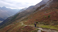
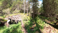
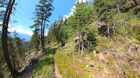
Photos of Davos Mountain Bike
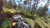
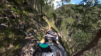
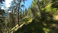
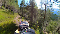
Videos of Davos Mountain Bike
trail: Jakobshorn - Teufi
0:16 |
165 |
Sep 20, 2021
trail: Tieftobel
0:31 |
40 |
Aug 30, 2021
trail: Tieftobel
0:35 |
42 |
Aug 30, 2021
trail: Tieftobel
0:16 |
25 |
Aug 30, 2021
trail: Steigtobel Trail
0:17 |
43 |
Aug 26, 2021
trail: Steigtobel Trail
0:19 |
26 |
Aug 26, 2021
trail: Steigtobel Trail
0:15 |
16 |
Aug 26, 2021
trail: Steigtobel Trail
0:20 |
21 |
Aug 26, 2021
Current Trail Warnings
| status | trail | date | condition | user | info |
|---|---|---|---|---|---|
| Teuf Zügji | Jul 6, 2026 @ 9:22am (Europe/Vaduz) 3 days | Dry | days-on-trails IGMTBZug | Forestry at work | |
| Gotschna Freeride | Jun 30, 2026 @ 11:52am (Europe/Vaduz) Jun 30, 2026 | Ideal | hillrocka | Sector I a lot of demage by cows and big... |
Recent Trail Reports
Activity Feed
| username | action | type | title | date |
|---|---|---|---|---|
| hillrocka | add | report | activity #98718408 | Jul 8, 2026 @ 9:00am 12 hours |
| vantourer630 | wishlist | route | activity #98698222 | Jul 8, 2026 @ 1:58am 19 hours |
| days-on-trails | add | report | activity #98691085 and 30 more | Jul 7, 2026 @ 10:00pm 23 hours |
| TristanZWk9IR | ridden | trail | activity #98657607 | Jul 7, 2026 @ 11:47am 1 day |
| keetoo | ridden | route | activity #98583433 | Jul 6, 2026 @ 10:15am 2 days |
Recent Comments
| username | type | title | comment | date |
|---|---|---|---|---|
| trail | Fun trail but NOT for beginners! Rating at... | Jun 27, 2026 @ 7:59am Jun 27, 2026 | ||
| report | Trail Closed due to forest working | Jun 17, 2026 @ 12:50am Jun 17, 2026 | ||
| trail | Landschaftlich sehr schöner Trail mit... | Jun 17, 2026 @ 12:41am Jun 17, 2026 | ||
| trail | Landschaftlich sehr schöner Trail mit... | Jun 17, 2026 @ 12:40am Jun 17, 2026 | ||
| trail | Habe ich genauso wahrgenommen :-) und... | Apr 13, 2026 @ 9:17am Apr 13, 2026 |
Local Badges
-

10 Black Trails24 awarded -

Descent 100k Badge22 awarded -

Descent 10k Badge492 awarded -

Big Ride 30k4,263 awarded -

Epic Ride 50k1,858 awarded -

Top 10 Trails4 awarded
Bike & Skill Parks
| name | type | city | rating |
|---|---|---|---|
| Adventure Park Davos Färich | skill park | Davos |
Activity Type Stats
| activitytype | trails | distance | descent | descent distance | total vertical | rating | global rank | state rank | photos | reports | routes | ridelogs |
|---|---|---|---|---|---|---|---|---|---|---|---|---|
| Mountain Bike | 207 | 259 miles | 103,415 ft | 155 miles | 6,309 ft | #267 | #2 | 699 | 6,497 | 9 | 14,431 | |
| E-Bike | 198 | 244 miles | 95,860 ft | 145 miles | 6,309 ft | #94 | #38 | 6 | 6,126 | 18 | 1,608 | |
| Gravel Bike | 5 | #178 | #38 | 15 | 65 | |||||||
| Adaptive Bike | 4 | #123 | #87 | 6 | 2 | |||||||
| Hike | 210 | 265 miles | 106,804 ft | 159 miles | 6,309 ft | #258 | #10 | 6,212 | 1 | 1,273 | ||
| Trail Running | 212 | 265 miles | 106,804 ft | 159 miles | 6,309 ft | #216 | #9 | 6,212 | 1 | 396 | ||
| Backcountry Ski | 3 | 4 miles | 6,991 ft | 4 miles | 3,386 ft | #33 | #3 | 7 | 886 |
Frequently Asked Questions About Davos
▼
What are the best places to ride in Davos?
Davos has 1 areas to explore for mountain biking. The top rated areas are:
▼
What are the highest rated mountain biking trails in Davos?
The highest rated mountain biking trails in Davos are:
- Chalbersäss (4.7/5)
- Signal (4.7/5)
- Alps Epic Trail: Jakobshorn - Sertig (4.6/5)
- Meierhoftäli (4.6/5)
- Chörbschhorn (4.5/5)
▼
What is the best time of the year to ride in Davos?
Based on ride log data, the most popular months to ride in Davos are:
- July (262 activities)
- August (214 activities)
- September (150 activities)
▼
Where can I park to ride in Davos?
There are 10 parking locations listed in Davos. The most popular parking spots are: View all parking and trailhead locations on the map to plan your visit.
Activities
Trails
Points of Interest
- Repeater Campground Camping
- Camping Rinerlodge
- Aussichtspunkt Wiesner Viadukt Viewpoint
- Restaurant Other
- Weissfluhjoch Summit
- Jakobshorn Summit
- Rock Garden Highline TTF
- Rock Garden Center Line TTF
- Rock Garden Right Line TTF
- Grialetschhütte Lodge
- Piz Grialetsch (10,115 ft)
- Flüela Wisshorn (10,049 ft)
- Scalettahorn (9,993 ft)
- By marcosnow
 TCD trailworks & contributors
 - Admins: TCD
- #14094 - 34,097 views
- davos activity log | embed map of Davos mountain bike trails | davos mountain biking points of interest polygons
Downloading of trail gps tracks in kml & gpx formats is enabled for Davos.
You must login to download files.