close
-
Layers w
- Weather Layers
- Pro
- Pro
- Pro
- Pro
- Pro
- Pro
- More Layers
- Pro
- Pro
- Pro
- Pro
-
Upgrade to

3D
Trail Conditions
- Unknown
- Snow Groomed
- Snow Packed
- Snow Covered
- Snow Cover Partial
- Freeze/thaw Cycle
- Icy
- Prevalent Mud
- Wet
- Variable
- Ideal
- Dry
- Very Dry
Trail Flow (Ridden Direction)
Trailforks scans users ridelogs to determine the most popular direction each trail is ridden. A good flowing trail network will have most trails flowing in a single direction according to their intension.
The colour categories are based on what percentage of riders are riding a trail in its intended direction.
The colour categories are based on what percentage of riders are riding a trail in its intended direction.
- > 96%
- > 90%
- > 80%
- > 70%
- > 50%
- < 50%
- bi-directional trail
- no data
Trail Last Ridden
Trailforks scans ridelogs to determine the last time a trail was ridden.
- < 2 days
- < 1 week
- < 2 weeks
- < 1 month
- < 6 months
- > 6 months
Trail Ridden Direction
The intended direction a trail should be ridden.
- Downhill Only
- Downhill Primary
- Both Directions
- Uphill Primary
- Uphill Only
- One Direction
Contribute Details
Colors indicate trail is missing specified detail.
- Description
- Photos
- Description & Photos
- Videos
Trail Popularity ?
Trailforks scans ridelogs to determine which trails are ridden the most in the last 9 months.
Trails are compared with nearby trails in the same city region with a possible 25 colour shades.
Think of this as a heatmap, more rides = more kinetic energy = warmer colors.
- most popular
- popular
- less popular
- not popular
ATV/ORV/OHV Filter
Max Vehicle Width
inches
US Cell Coverage
Legend

Radar Time
Activity Recordings
Trailforks uses anonymized public activity data.
?
Activity Recordings
Trailforks uses anonymized public activity data.
?
Personal Heatmap
▶
Activity Types
all
/
none
▶
Options
2
Date range
month
–
Winter Trails
Warning
A routing network for winter maps does not exist. Selecting trails using the winter trails layer has been disabled.
Missing Trails
Most Popular
Least Popular
Trails are colored based on popularity. The more popular a trail is, the more red. Less popular trails trend towards green.
Jump Magnitude Heatmap
Heatmap of where riders jump on trails. Zoom in to see individual jumps, click circles to view jump details.
BC Backroad Status
![map legend]()
Service Road Atlas is a free to use, community-driven service for viewing and creating reports on the numerous back-country service roads around B.C. and Alberta.

Slope Aspect
Direction the slope faces
Trails Deemphasized
Trails are shown in grey.
Only show trails with no bike usage.
Suggested Layers
Based on selected activity type
Save the current map location and zoom level as your default home location whenever this page is loaded.
SaveForebay is a recreation area owned and managed by Payson City, designated specifically for non motorized outdoor activities. The area is permanently protected under a conservation easement, ensuring that public access remains open and that the land is preserved for its intended uses.
The trail system began with the vision of local mountain bike enthusiast Carey Pierce, who designed the core network of trails. Throughout the process, he rallied fellow mountain bikers and community volunteers to help hand build, shape and refine the trails into the system enjoyed today.
Primary activities at Forebay include mountain biking, hiking, trail running, and — during the winter months — snowshoeing, cross country skiing, and fat biking. The riding style is predominantly cross country, making it a favored training location for many high school mountain bike teams participating in the National Interscholastic Cycling Association (NICA).
Looking ahead, future enhancements such as a dedicated skills park and new flow style trails are actively being discussed. Stay tuned for exciting developments to come.
Primary Trail Type: Cross-Country
Land Status: City Managed
Land Manager: Payson City
 google parking directions
 Region Supporters & Maintainers
![USFS]()
USFSSponsor![BSA]()
BSASponsor![Payson City Utah]()
Payson City UtahBuilder![]()
Friends of ForebayMaintainer
Activities Click to view
- Mountain Bike
39 trails
- E-Bike
24 trails
- Horse
5 trails
- Hike
44 trails
- Trail Running
44 trails
- Snowshoe
22 trails
Region Details
- 2
- 1
- 13
- 16
- 4
- 1
Region Status
Open as of Jun 14, 2026Stats
- Avg Trail Rating
- Trails (view details)
- 40
- Trails Mountain Bike
- 41
- Trails E-Bike
- 24
- Trails Gravel Bike
- 3
- Trails Winter Fat Bike
- 24
- Trails Horse
- 5
- Trails Hike
- 44
- Trails Trail Running
- 44
- Trails Snowmobile
- 1
- Trails Snowshoe
- 22
- Total Distance
- 21 miles
- Total Descent Distance
- 7 miles
- Total Descent
- 2,324 ft
- Total Vertical
- 1,219 ft
- Highest Trailhead
- 6,198 ft
- Reports
- 3,744
- Photos
- 160
- Ridden Counter
- 7,650
Popular Forebay Mountain Biking Trails
• 100 ★ 3.5 • 2,999 ft • 160 ft • 418 •
The lower section of Trotters is heavily wooded with tight turns in shady basin. There is a few spring crossings along with a section of exposed trail and great views of Payson canyon as you climb to the junction.
• 95 ★ 3.9 • 2,408 ft • 68 ft • 417 •
is one of the OG Forebay trails. It doesn't have to be your , but it's ours. Easy trail with a nice flow through the oak and maple trees. it's a nice place to catch your breath after climbing up from the main forebay parking lot.
• 100 ★ 3.2 • 2 miles • 266 ft • 386 •
Short climbs and some tight turns. Expect spectacular views in the spring, fall and winter. In 2025 a new bridge and several berms were constructed to help with flow. A center shortcut was also added to allow to be ridden in a figure 8.
• 95 ★ 3.4 • 3,127 ft • 42 ft • 345 •
Raygun has several tight corners with limited visibility. Moderate grade for descending and climbing. Great for beginners that are ready to advance to intermediate trails.
• 90 ★ 3.0 • 1,903 ft • 36 ft • 324 •
Great views and home to Rusty the chair, who has been watching over Forebay for several decades.
Forebay Mountain Bike Routes
4 miles • 618 ft • 5 • Out & Back •
Climb , , one loop on . Down Raygun, , Jax to . Sprint up . Repeat Raygun, , Jax and sprints up .
2 miles • 468 ft • 5 • Out & Back •
Climb , Trotters and to the Pond. to Jax, down Jax to . Sprint up , Mez. Repeat to Jax, down Jax to ....
4 miles • 239 ft • 10 • Out & Back •
Pre-race workout race out and back with loop options on raygun and
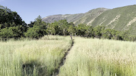
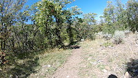
Photos of Forebay Mountain Bike
Recent Trail Reports
| status | trail | date | condition | info | user |
|---|---|---|---|---|---|
| Wakara Cutoff | Jun 14, 2026 @ 8:36am (America/Denver) Jun 14, 2026 | Dry | mtstewart74 Forebay | ||
| Wakara | Jun 14, 2026 @ 8:36am (America/Denver) Jun 14, 2026 | Dry | mtstewart74 Forebay | ||
| Uncle Rico | Jun 14, 2026 @ 8:36am (America/Denver) Jun 14, 2026 | Dry | mtstewart74 Forebay | ||
| Trotter | Jun 14, 2026 @ 8:36am (America/Denver) Jun 14, 2026 | Dry | mtstewart74 Forebay | ||
| Tithing Mountain | Jun 14, 2026 @ 8:36am (America/Denver) Jun 14, 2026 | Dry | mtstewart74 Forebay | ||
| TECH LINE | Jun 14, 2026 @ 8:36am (America/Denver) Jun 14, 2026 | Dry | mtstewart74 Forebay | ||
| Taze | Jun 14, 2026 @ 8:36am (America/Denver) Jun 14, 2026 | Dry | mtstewart74 Forebay | ||
| Round Top | Jun 14, 2026 @ 8:36am (America/Denver) Jun 14, 2026 | Dry | mtstewart74 Forebay | ||
| Ray Gun | Jun 14, 2026 @ 8:36am (America/Denver) Jun 14, 2026 | Dry | mtstewart74 Forebay | ||
| Pipeline Alt | Jun 14, 2026 @ 8:36am (America/Denver) Jun 14, 2026 | Dry | mtstewart74 Forebay |
Activity Feed
| username | action | type | title | date |
|---|---|---|---|---|
| TransientVagrantRN | ridden | trail | activity #98174140 and 2 more | Jun 30, 2026 @ 7:30pm 2 hours |
| HopsBike | wishlist | route | activity #98044836 | Jun 28, 2026 @ 10:03pm 2 days |
| Reggimann | vote | trail | activity #97396246 and 1 more | Jun 20, 2026 @ 8:05am Jun 20, 2026 |
| Reggimann | add | photo | activity #97396235 | Jun 20, 2026 @ 8:05am Jun 20, 2026 |
| Reggimann | comment | trail | activity #97396155 | Jun 20, 2026 @ 8:04am Jun 20, 2026 |
Recent Comments
| username | type | title | comment | date |
|---|---|---|---|---|
| trail | Not a black going down. Nice flow, couple... | Jun 20, 2026 @ 8:04am Jun 20, 2026 | ||
| trail | Does this trail legally have equestrian use? I... | Mar 31, 2026 @ 11:55am Mar 31, 2026 | ||
| report | Feel free to check my ride log... my account... | Nov 18, 2025 @ 9:47am Nov 18, 2025 | ||
| report | I sure do. I also preform the maintenance on... | Nov 18, 2025 @ 9:37am Nov 18, 2025 | ||
| report | Do you even ride these trails or just post... | Nov 18, 2025 @ 8:07am Nov 18, 2025 |
Nearby Areas
| name | distance | ||||
|---|---|---|---|---|---|
| Payson Canyon | 6 | 13 | 6 | 3 | 2.2 km |
| Santaquin Bench | 6 | 7 | 2 | 5.2 km | |
| Prospector View Park | 11 | 6 | 2 | 5.4 km | |
| Mt. Loafer Wildlife Management Area | 1 | 1 | 1 | 6.3 km | |
| Spanish Oaks | 7 | 12 | 9 | 1 | 7.1 km |
Local Badges
-

Completionist0 awarded
Activity Type Stats
| activitytype | trails | distance | descent | descent distance | total vertical | rating | global rank | state rank | photos | reports | routes | ridelogs |
|---|---|---|---|---|---|---|---|---|---|---|---|---|
| Mountain Bike | 39 | 20 miles | 2,087 ft | 7 miles | 554 ft | #2,419 | #836 | 156 | 3,742 | 8 | 5,937 | |
| E-Bike | 24 | 12 miles | 1,453 ft | 4 miles | 554 ft | #5,541 | #1,532 | 1,846 | 467 | |||
| Gravel Bike | 3 | 3 miles | 112 ft | 4,577 ft | 161 ft | #1,081 | #558 | 151 | ||||
| Winter Fat Bike | 24 | 11 miles | 1,106 ft | 3 miles | 554 ft | #1,081 | #558 | 1,327 | ||||
| Horse | 5 | 6 miles | 469 ft | 2 miles | 1,220 ft | #2,008 | #1,072 | 3,193 | 7 | |||
| Hike | 44 | 21 miles | 2,323 ft | 7 miles | 1,220 ft | #1,415 | #658 | 5 | 3,744 | 1 | 410 | |
| Trail Running | 44 | 21 miles | 2,323 ft | 7 miles | 1,220 ft | #5,555 | #1,714 | 3,744 | 1 | 824 | ||
| Snowmobile | 1 | 1,381 ft | 82 ft | 1 | 1 | |||||||
| Snowshoe | 22 | 11 miles | 1,099 ft | 3 miles | 554 ft | #862 | #402 | 2,284 | 25 |
Frequently Asked Questions About Forebay
▼
What are the highest rated mountain biking trails in Forebay?
The highest rated mountain biking trails in Forebay are:
- Loadin' Chute (4.1/5)
- Ezra (4/5)
- Noah on the Low (4/5)
- Jr Devo (4/5)
- Bones (4/5)
▼
What is the best time of the year to ride in Forebay?
Based on ride log data, the most popular months to ride in Forebay are:
- July (134 activities)
- June (84 activities)
- May (77 activities)
▼
Where can I park to ride in Forebay?
There are 2 parking locations listed in Forebay. The most popular parking spots are:
▼
What is the longest trail in Forebay?
The longest trail in Forebay is Wakara at 2.3 miles. View all trails sorted by distance.
Activities
Trails
Points of Interest
- By todd
 Trailforks & contributors
 - Admins: Forebay, URMB, UVTA
- #30392 - 6,173 views
- forebay activity log | embed map of Forebay mountain bike trails | forebay mountain biking points of interest
Downloading of trail gps tracks in kml & gpx formats is enabled for Forebay.
You must login to download files.