close
-
Layers w
- Weather Layers
- Pro
- Pro
- Pro
- Pro
- Pro
- Pro
- More Layers
- Pro
- Pro
- Pro
- Pro
-
Upgrade to

3D
Trail Conditions
- Unknown
- Snow Groomed
- Snow Packed
- Snow Covered
- Snow Cover Partial
- Freeze/thaw Cycle
- Icy
- Prevalent Mud
- Wet
- Variable
- Ideal
- Dry
- Very Dry
Trail Flow (Ridden Direction)
Trailforks scans users ridelogs to determine the most popular direction each trail is ridden. A good flowing trail network will have most trails flowing in a single direction according to their intension.
The colour categories are based on what percentage of riders are riding a trail in its intended direction.
The colour categories are based on what percentage of riders are riding a trail in its intended direction.
- > 96%
- > 90%
- > 80%
- > 70%
- > 50%
- < 50%
- bi-directional trail
- no data
Trail Last Ridden
Trailforks scans ridelogs to determine the last time a trail was ridden.
- < 2 days
- < 1 week
- < 2 weeks
- < 1 month
- < 6 months
- > 6 months
Trail Ridden Direction
The intended direction a trail should be ridden.
- Downhill Only
- Downhill Primary
- Both Directions
- Uphill Primary
- Uphill Only
- One Direction
Contribute Details
Colors indicate trail is missing specified detail.
- Description
- Photos
- Description & Photos
- Videos
Trail Popularity ?
Trailforks scans ridelogs to determine which trails are ridden the most in the last 9 months.
Trails are compared with nearby trails in the same city region with a possible 25 colour shades.
Think of this as a heatmap, more rides = more kinetic energy = warmer colors.
- most popular
- popular
- less popular
- not popular
ATV/ORV/OHV Filter
Max Vehicle Width
inches
US Cell Coverage
Legend

Radar Time
Activity Recordings
Trailforks uses anonymized public activity data.
?
Activity Recordings
Trailforks uses anonymized public activity data.
?
Personal Heatmap
▶
Activity Types
all
/
none
▶
Options
2
Date range
month
–
Winter Trails
Warning
A routing network for winter maps does not exist. Selecting trails using the winter trails layer has been disabled.
Missing Trails
Most Popular
Least Popular
Trails are colored based on popularity. The more popular a trail is, the more red. Less popular trails trend towards green.
Jump Magnitude Heatmap
Heatmap of where riders jump on trails. Zoom in to see individual jumps, click circles to view jump details.
BC Backroad Status
![map legend]()
Service Road Atlas is a free to use, community-driven service for viewing and creating reports on the numerous back-country service roads around B.C. and Alberta.

Slope Aspect
Direction the slope faces
Trails Deemphasized
Trails are shown in grey.
Only show trails with no bike usage.
Suggested Layers
Based on selected activity type
Save the current map location and zoom level as your default home location whenever this page is loaded.
SaveWest Eagle trails are around Hardscrabble Mountain and the 7 Hermits in between Eagle and Gypsum. A mix of primarily mountain biking and dirt bike trails.
 google parking directions
Links
IMBA Ride Center

Vail Valley
Activities Click to view
- Mountain Bike
39 trails
- E-Bike
21 trails
- Horse
21 trails
- Hike
43 trails
- Trail Running
43 trails
- Dirtbike/Moto
21 trails
- ATV/ORV/OHV
5 trails
Region Details
- 4
- 1
- 4
- 17
- 9
- 1
Region Status
Open as of Jun 2, 2026Stats
- Avg Trail Rating
- Trails (view details)
- 36
- Trails Mountain Bike
- 42
- Trails E-Bike
- 21
- Trails Horse
- 21
- Trails Hike
- 43
- Trails Trail Running
- 43
- Trails Dirtbike/Moto
- 21
- Trails ATV/ORV/OHV
- 5
- Total Distance
- 53 miles
- Total Descent
- 12,501 ft
- Total Vertical
- 4,160 ft
- Highest Trailhead
- 10,757 ft
- Reports
- 1,238
- Photos
- 152
- Ridden Counter
- 5,641
Popular West Eagle Mountain Biking Trails
• 80 ★ 4.5 • 1 mile • 0 ft • 575 •
Branch off connector from to World's Greatest. A fast straight away with mild turns. It's not advised to climb this trail. It's a very fast down hill with blind turns and head on accidents have happened a number of times. Please use...
• 80 ★ 4.4 • 2 miles • 29 ft • 525 •
A super fun, fast descent. Expect more rock and chunk compared to most of the trails in Eagle. *Closed to bikes Dec 1 - Apr 15 each year to protect deer/elk populations
• 65 ★ 3.5 • 2,674 ft • 39 ft • 360 •
Short, optional connector trail *Closed to bikes Dec 1 - Apr 15 each year to protect deer/elk populations
• 70 ★ 4.7 • 3 miles • 172 ft • 358 •
Fast and fun to ride downhill. *Closed to bikes Dec 1 - Apr 15 each year to protect deer/elk populations
• 85 ★ 4.5 • 2,598 ft • 0 ft • 327 •
Singletrack split from that meets a doubletrack/road to continue the climb
• 65 ★ 3.4 • 1 mile • 128 ft • 281 •
*Closed to bikes Dec 1 - Apr 15 each year to protect deer/elk populations
• 65 ★ 4.4 • 3 miles • 938 ft • 267 •
is a multi directional trail that travels along... you guessed it, . If you're climbing, it's a bit of a lung buster with a handful of very steep sections that might be short hike-a-bikes for some riders. If you're descending, it's a...
West Eagle Mountain Bike Routes
15 miles • 1,137 ft • 2 • Shuttled •
From epic above-treeline singletrack in the highcountry, through countless Aspen groves, all the way to...
11 miles • 2,011 ft • 0 • Out & Back •
The Harry Gates Hut is reminiscent of a refuge in the Austrian Tyrol, standing at the edge of a meadow...
★ 5.0 • 26 miles • 2,740 ft • 8 • Race •
Stop # 2 in Eagle Colorado will consist of 4 stages of backcountry racing! This will be a one-day race on...
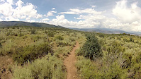
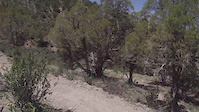
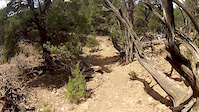
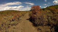
Photos of West Eagle Mountain Bike
Videos of West Eagle Mountain Bike
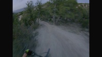
trail: Worlds Greatest
0:48 |
104 |
Sep 30, 2021
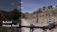
trail: School House Rock
2:13 |
91 |
Oct 15, 2017
trail: Tick Alley
0:10 |
106 |
Oct 15, 2017
trail: Abrams Gulch Connector
0:11 |
58 |
Oct 15, 2017
trail: Itch
0:04 |
35 |
Oct 15, 2017
trail: School House Rock
0:03 |
31 |
Oct 15, 2017
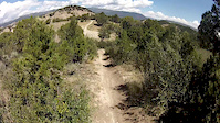
trail: Abrams Ridge
0:59 |
225 |
Oct 15, 2017
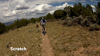
trail: Scratch
0:54 |
34 |
Oct 15, 2017
Recent Trail Reports
| status | trail | date | condition | info | user |
|---|---|---|---|---|---|
| Abrams Gulch Connector | Jun 2, 2026 @ 3:27pm (America/Denver) Jun 2, 2026 | Very Dry | maynardco | ||
| Cat Walk | May 27, 2026 @ 10:00pm (America/Denver) May 27, 2026 | Unknown | RidetoShredPow270Jmirj | ||
| Mikes Night Out | May 27, 2026 @ 10:00pm (America/Denver) May 27, 2026 | Unknown | RidetoShredPow270Jmirj | ||
| Worlds Greatest | May 16, 2026 @ 2:19pm (America/Denver) May 16, 2026 | Dry | poleczechy | ||
| Sawmill | May 16, 2026 @ 2:19pm (America/Denver) May 16, 2026 | Snow Cover Partial | poleczechy | ||
| Kill Bill | May 16, 2026 @ 9:58am (America/Denver) May 16, 2026 | Ideal | esaeger1 VVMTA | ||
| Scratch | May 16, 2026 @ 9:58am (America/Denver) May 16, 2026 | Ideal | esaeger1 VVMTA | ||
| Firebox | May 16, 2026 @ 9:58am (America/Denver) May 16, 2026 | Ideal | esaeger1 VVMTA | ||
| Pipeline | May 16, 2026 @ 9:58am (America/Denver) May 16, 2026 | Ideal | esaeger1 VVMTA | ||
| Pipeline/3rd Gulch Connector | May 16, 2026 @ 9:58am (America/Denver) May 16, 2026 | Unknown | esaeger1 VVMTA |
Activity Feed
| username | action | type | title | date |
|---|---|---|---|---|
| JacelQXrKz | wishlist | trail | activity #96509868 | Jun 7, 2026 @ 5:18pm Jun 7, 2026 |
| ajriding | vote | trail | activity #96324011 and 5 more | Jun 5, 2026 @ 3:12pm Jun 5, 2026 |
| ajriding | comment | trail | activity #96324005 and 6 more | Jun 5, 2026 @ 3:12pm Jun 5, 2026 |
| maynardco | add | report | activity #96116630 | Jun 2, 2026 @ 4:15pm Jun 2, 2026 |
| RidetoShredPow270Jmirj | add | report | activity #95684562 and 1 more | May 27, 2026 @ 9:00pm May 27, 2026 |
Recent Comments
| username | type | title | comment | date |
|---|---|---|---|---|
| trail | Fun trail. Its all clay but swoopy n fun.... | Jun 5, 2026 @ 3:26pm Jun 5, 2026 | ||
| trail | Decent lil trail. Nutun special. There was a... | Jun 5, 2026 @ 3:25pm Jun 5, 2026 | ||
| trail | I was hoping was not a moto trail. Either... | Jun 5, 2026 @ 3:23pm Jun 5, 2026 | ||
| trail | Easy to miss a turn. It gets super steep,... | Jun 5, 2026 @ 3:20pm Jun 5, 2026 | ||
| trail | Beautiful views at top. I rode up the bad rd... | Jun 5, 2026 @ 3:18pm Jun 5, 2026 |
Nearby Areas
| name | distance | ||||
|---|---|---|---|---|---|
| Eagle Ranch | 9 | 3 km | |||
| East Eagle | 3 | 6 | 2 | 5.2 km | |
| Red Hill Trails | 2 | 2 | 9.1 km | ||
| South Eagle | 10.2 km | ||||
| Bocco Mountain | 4 | 4 | 1 | 12.4 km |
Local Badges
-

Completionist0 awarded
Activity Type Stats
| activitytype | trails | distance | descent | descent distance | total vertical | rating | global rank | state rank | photos | reports | routes | ridelogs |
|---|---|---|---|---|---|---|---|---|---|---|---|---|
| Mountain Bike | 39 | 53 miles | 12,500 ft | 29 miles | 4,160 ft | #2,660 | #926 | 155 | 1,355 | 5 | 2,874 | |
| E-Bike | 21 | 30 miles | 6,299 ft | 15 miles | 3,422 ft | #3,985 | #1,127 | 1,243 | 1 | 111 | ||
| Horse | 21 | 33 miles | 6,663 ft | 16 miles | 3,422 ft | #1,277 | #652 | 1,032 | 1 | 4 | ||
| Hike | 43 | 53 miles | 12,500 ft | 29 miles | 4,160 ft | #4,010 | #1,421 | 1,355 | 2 | 466 | ||
| Trail Running | 43 | 53 miles | 12,500 ft | 29 miles | 4,160 ft | #3,348 | #895 | 1 | 1,355 | 2 | 143 | |
| Dirtbike/Moto | 21 | 30 miles | 6,299 ft | 15 miles | 3,422 ft | #689 | #244 | 1,030 | 1 | 16 | ||
| ATV/ORV/OHV | 5 | 12 miles | 2,211 ft | 6 miles | 3,360 ft | #256 | #49 | 998 | 1 |
Frequently Asked Questions About West Eagle
▼
What are the highest rated mountain biking trails in West Eagle?
The highest rated mountain biking trails in West Eagle are:
- Abrams Gulch (4.7/5)
- Mikes Night Out (4.5/5)
- Abrams to Firebox Road (461) Connector (4.5/5)
- Abrams Gulch Connector (4.3/5)
- Worlds Greatest (4.3/5)
▼
What is the best time of the year to ride in West Eagle?
Based on ride log data, the most popular months to ride in West Eagle are:
- June (41 activities)
- May (36 activities)
- April (23 activities)
▼
Where can I park to ride in West Eagle?
There are 2 parking locations listed in West Eagle. The most popular parking spots are:
▼
What is the longest trail in West Eagle?
The longest trail in West Eagle is Sawmill at 4.3 miles. View all trails sorted by distance.
Activities
Trails
Points of Interest
- By esaeger1
 VVMTA & contributors
 - Admins: VVMTA, HTC, EagleOutside, VVMTA, VVMTA, HTC
- #36748 - 4,509 views
- west eagle activity log | embed map of West Eagle mountain bike trails | west eagle mountain biking points of interest
Downloading of trail gps tracks in kml & gpx formats is enabled for West Eagle.
You must login to download files.