18.0 miles
Distance
1,374 ft
Climb
-1,370 ft
Descent
1 mile
High Point
5 ft
Altitude change
5,561 ft
Altitude min
5,852 ft
Altitude start
5,856 ft
Altitude end
-28.2%
Grade max
26%
Grade min
8 miles
Distance climb
7 miles
Distance down
3 miles
Distance flat

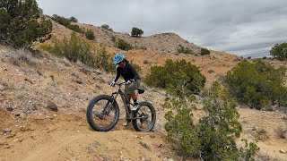
Fat bike specific loop to avoid singletrack trail damage and reduce erosion. Challenging loop that rolls through sandy singletrack and sandy arroyos.

Detailed Description
Fatastic Loop is a 18 mile moderately popular expert route located near Rio Rancho New Mexico. This mountain bike only route can be used one direction and has a extreme overall physical rating. This route includes 9 trails. This route climbs 1,374 ft with a max elevation of 6,106 ft then descends -1,370 ft.
Local Trail Association
Local trail association
Mariposa Fat Bike Society (www.facebook.com)
Please consider joining or donating to the local riding association to support trail development & maintenance.
Donate to earn trail karma!

Stats

  • Distance
    18 miles
  • Avg time
    2 hr 56 min
  • Altitude min
    5,561 ft
  • Altitude start
    5,852 ft
  • Altitude end
    5,856 ft
  • Climb
    1,374 ft
  • Descent
    -1,370 ft
  • Grade max
    -28.2%
  • Grade min
    26%
  • Distance climb
    8 miles
  • Distance down
    7 miles
  • Distance flat
    3 miles

Comments


We hope you've been enjoying Trailforks!

Create a FREE account to view route comments and much more.

Trails in Route

Details

  • Riding area
  • Primary Activity
    Mountain Bike
  • Difficulty rating
    Black Diamond
  • Route Type
    Loop
  • eBike Allowed
  • Bike type
    Fat
  • Direction
    One Direction
  • Physical rating
    Extreme
no votes yet
close
3D
Trail Conditions
  • Unknown
  • Snow Groomed
  • Snow Packed
  • Snow Covered
  • Snow Cover Partial
  • Freeze/thaw Cycle
  • Icy
  • Prevalent Mud
  • Wet
  • Variable
  • Ideal
  • Dry
  • Very Dry
Trail Flow (Ridden Direction)
Trailforks scans users ridelogs to determine the most popular direction each trail is ridden. A good flowing trail network will have most trails flowing in a single direction according to their intension.
The colour categories are based on what percentage of riders are riding a trail in its intended direction.
  • > 96%
  • > 90%
  • > 80%
  • > 70%
  • > 50%
  • < 50%
  • bi-directional trail
  • no data
Trail Last Ridden
Trailforks scans ridelogs to determine the last time a trail was ridden.
  • < 2 days
  • < 1 week
  • < 2 weeks
  • < 1 month
  • < 6 months
  • > 6 months
Trail Ridden Direction
The intended direction a trail should be ridden.
  • Downhill Only
  • Downhill Primary
  • Both Directions
  • Uphill Primary
  • Uphill Only
  • One Direction
Contribute Details
Colors indicate trail is missing specified detail.
  • Description
  • Photos
  • Description & Photos
  • Videos
Trail Popularity ?
Trailforks scans ridelogs to determine which trails are ridden the most in the last 9 months. Trails are compared with nearby trails in the same city region with a possible 25 colour shades. Think of this as a heatmap, more rides = more kinetic energy = warmer colors.
  • most popular
  • popular
  • less popular
  • not popular
ATV/ORV/OHV Filter
Max Vehicle Width
inches
US Cell Coverage
Legend
cell carrier legend

Radar Time
Activity Recordings
Trailforks uses anonymized public activity data. ?
Activity Recordings
Trailforks uses anonymized public activity data. ?
Personal Heatmap
Activity Types
all / none
Options
2
Date range month
Winter Trails
Warning A routing network for winter maps does not exist. Selecting trails using the winter trails layer has been disabled.
Missing Trails
Most Popular
Least Popular
Trails are colored based on popularity. The more popular a trail is, the more red. Less popular trails trend towards green.
Jump Magnitude Heatmap
Heatmap of where riders jump on trails. Zoom in to see individual jumps, click circles to view jump details.
BC Backroad Status

Service Road Atlas is a free to use, community-driven service for viewing and creating reports on the numerous back-country service roads around B.C. and Alberta.

map legend
Slope Aspect
Direction the slope faces
Flat N NE E SE S SW W NW
Trails Deemphasized
Trails are shown in grey.
disable
Only show trails with no bike usage.
Enable
Suggested Layers
Based on selected activity type

    Save the current map location and zoom level as your default home location whenever this page is loaded.

    Save
    Trail transparency
    • Singletrack
    2
    2
    3
    4
    youtuber Fat Tires And Cactus Flower Explosion
    Fat Tires And Cactus Flower Explosion
    6:56 | 26 | comments: 0 | favs:
    May 1, 2026
    The “Big Storm” Here In New Mexico
    The “Big Storm” Here In New Mexico
    7:17 | 18 | comments: 0 | favs:
    Jan 25, 2026

    Recent Trail Reports Along Route

    statustraildateconditiondescription
    Mini Badlands Fat Bike Loop
    Jun 15, 2026 @ 9:23am (America/Ciudad_Juarez)
    3 days
    Overlook
    Jun 15, 2026 @ 9:23am (America/Ciudad_Juarez)
    3 days
    Preserve Arroyo
    Jun 9, 2026 @ 5:39pm (America/Ciudad_Juarez)
    Jun 9, 2026
    Middle Reservoir
    May 29, 2026 @ 8:53am (America/Ciudad_Juarez)
    May 29, 2026
    Lower Reservoir
    May 12, 2026 @ 10:39am (America/Ciudad_Juarez)
    May 12, 2026
    more reports »
    • By TerraFormerTF Pro MFBS & contributors
    • #26353 - 653 views

    Hit the Trail

    Open in App

    Get this route on your phone instantly.

    Download Route

    Save to wishlist, Garmin & download.