

Open in App
Get this trail on your phone instantly.

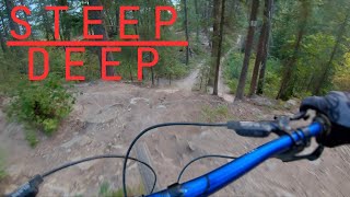
This trail is often shuttled, but depending on the bike you are riding, can easily be done as a
circuit (pedalling up the road, and down the trail). Before you start, have a quick listen and look
up trail for any riders that may be coming from higher up the trail system.
A DH bike is not a necessity on this trail, and can quite easily be done on an enduro, or xc, but
note that there are some features where the ride-around option might better suited if you’re on
such a bike.
The trail begins with a couple tight turns leading into a moderate pitch into a tight right with a
slight uphill. Continuing on, the trail picks up speed to your first area of options known as Root
Drop:
Option 1. If you stay on the fall-line (the option to the left) it is a small mandatory drop (note: it is
possible to roll this drop, but it is recommended you inspect it first as there is an angled rock that
needs to be navigated). There is also a sign on the tree to the right indicating a steep drop.
Option 2 is the wood feature just to the right of option 1, and raises about 8 feet in the air, and
splits at the end. Riding the right split is a gentle slope down back onto the ride around trail. If you
continue on the boardwalk it is a mandatory gap drop to steep dirt. The gap is only a couple feet
wide and very little speed is needed to make the transfer.
Option 3 is the trail that goes to the far right, and it is the ride-around option. You can take this trail
around the woodwork completely which is the safest, easiest option. (Note that you will be
merging back onto the trail, give way to riders coming off either of the other trail options as the
runout is steep and quick).
All three options will merge back onto the main trail.
A quick flat section awaits with a few turns, bringing you to a slight uphill. Up ahead you will enter
an opening that has powerlines running perpendicular to the trail. It will look like you have options
for the roll down across the ATV trail, but the left is the only one that should be used. (the right
side is a deactivated jump from the Psychosis race, and would result in a flat landing).
As you cross the road you enter onto Tail Gate. You can choose between the left or right routes.
The left is the ride around option, the right is a wooden table top feature that can be rolled or
gapped. Following that is fast single track with a somewhat abrupt left turn.
You will now be entering a section of trail known as Snake Hill. Be aware that you will cross the
Selkirk Slacker xc trail, and although you have the right of way, you should watch for riders.
Bike or Shuttle up the Bowle-Evans Road to the 3K entrance.
| c1 | c2 | c3 | c4 |
|---|---|---|---|
January | February | March | April |
May | June | July | August |
September | October | November | December |

Service Road Atlas is a free to use, community-driven service for viewing and creating reports on the numerous back-country service roads around B.C. and Alberta.
Save the current map location and zoom level as your default home location whenever this page is loaded.
SaveWe hope you've been enjoying Trailforks!
Create a FREE account to view trail comments and much more.
You must enter a description before submitting.

