more stats
4,708 ft
Distance
303 ft
Climb
00:08:24
Avg time
303 ft
Altitude change
6,012 ft
Altitude min
6,315 ft
Altitude max
6,012 ft
Altitude start
6,316 ft
Altitude end
6.4%
Grade
0.6%
Grade max
18.9%
Grade min
4,606 ft
Distance climb
98 ft
Distance flat
00:08:24
Avg time

El Burro Trail Details

  • Activities
    • Mountain Bike
    • E-Bike
    • Hike
    • Trail Running
  • Riding Area
    Donkey Town
    Truckee, California
  • Difficulty Rating
  • Local Popularity
    100 in Mountain Biking [+]
    • 100 in E-Biking
    • 75 in Trail Running
    • 50 in Hiking
  • Global Ranking
    #27352 in Mountain Biking [+]
    • #2046 in E-Biking
    • #20514 in Trail Running
    • #120399 in Hiking
  • Hiking SAC Scale
    T1 Hiking
  • Trail Type
    Singletrack
  • Bike Type
    AM, XC
  • Direction
    Both Directions
    Popular In Reverse
  • Climb Difficulty
    Blue
  • Physical Rating
    Moderate
  • Trail Visibility
    Always easy to follow
  • Dogs Allowed
    Yes
  • eBike Allowed
    Yes up to Class 1
  • TTFs on Trail
    Berm, Jump, Rock Garden
  • Land Owner
    USFS - Truckee Ranger District

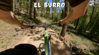
More of a quick, straight shot than Donkey Town Trail with a couple technical sections throughout.

While uphill traffic is allowed, this is primarily a downhill "feature" trail and climbing is strongly discouraged - local ethic is to climb the adjacent fire road.

Local Trail Association
Traditionally Indigenous Territory

Recent Activity on Trail

Past Week
  • 12 rides
  • 9 miles average
6 Months
  • 125 rides
  • 10 miles avg distance
All
  • 1,107 rides
  • Last: Jun 13, 2026
c1c2c3c4
January
February
March
April
May
June
July
August
September
October
November
December
update trails status or condition

El Burro Trail Trail Reports

Status:
on Apr 18, 2026
Avg: 4.42 (13 votes)
Your vote: 0

view (8,868)
close
3D
Trail Conditions
  • Unknown
  • Snow Groomed
  • Snow Packed
  • Snow Covered
  • Snow Cover Partial
  • Freeze/thaw Cycle
  • Icy
  • Prevalent Mud
  • Wet
  • Variable
  • Ideal
  • Dry
  • Very Dry
Trail Flow (Ridden Direction)
Trailforks scans users ridelogs to determine the most popular direction each trail is ridden. A good flowing trail network will have most trails flowing in a single direction according to their intension.
The colour categories are based on what percentage of riders are riding a trail in its intended direction.
  • > 96%
  • > 90%
  • > 80%
  • > 70%
  • > 50%
  • < 50%
  • bi-directional trail
  • no data
Trail Last Ridden
Trailforks scans ridelogs to determine the last time a trail was ridden.
  • < 2 days
  • < 1 week
  • < 2 weeks
  • < 1 month
  • < 6 months
  • > 6 months
Trail Ridden Direction
The intended direction a trail should be ridden.
  • Downhill Only
  • Downhill Primary
  • Both Directions
  • Uphill Primary
  • Uphill Only
  • One Direction
Contribute Details
Colors indicate trail is missing specified detail.
  • Description
  • Photos
  • Description & Photos
  • Videos
Trail Popularity ?
Trailforks scans ridelogs to determine which trails are ridden the most in the last 9 months. Trails are compared with nearby trails in the same city region with a possible 25 colour shades. Think of this as a heatmap, more rides = more kinetic energy = warmer colors.
  • most popular
  • popular
  • less popular
  • not popular
ATV/ORV/OHV Filter
Max Vehicle Width
inches
US Cell Coverage
Legend
cell carrier legend

Radar Time
Activity Recordings
Trailforks uses anonymized public activity data. ?
Activity Recordings
Trailforks uses anonymized public activity data. ?
Personal Heatmap
Activity Types
all / none
Options
2
Date range month
Winter Trails
Warning A routing network for winter maps does not exist. Selecting trails using the winter trails layer has been disabled.
Missing Trails
Most Popular
Least Popular
Trails are colored based on popularity. The more popular a trail is, the more red. Less popular trails trend towards green.
Jump Magnitude Heatmap
Heatmap of where riders jump on trails. Zoom in to see individual jumps, click circles to view jump details.
BC Backroad Status

Service Road Atlas is a free to use, community-driven service for viewing and creating reports on the numerous back-country service roads around B.C. and Alberta.

map legend
Slope Aspect
Direction the slope faces
Flat N NE E SE S SW W NW
Trails Deemphasized
Trails are shown in grey.
disable
Only show trails with no bike usage.
Enable
Suggested Layers
Based on selected activity type

    Save the current map location and zoom level as your default home location whenever this page is loaded.

    Save
        Directions to el-burro-trail trailhead (39.309610, -120.210460)

        Photos

        3 more »
        143 |
        Aug 21, 2021 @ 8:08am
        Aug 21, 2021
        139 |
        Aug 21, 2021 @ 8:08am
        Aug 21, 2021
        189 |
        Aug 21, 2021 @ 8:08am
        Aug 21, 2021

        Videos

        6 more »
        youtuber El Burro / Truckee, CA / MTB
        3:06 | 130 | Jul 8, 2024 , Truckee
        MTB Mud, Snow, and Falling Off the Log Ride |...
        19:31 | 17 | Dec 4, 2025 , Truckee
        youtuber El Burro
        11:38 | 80 | May 25, 2025 , Truckee
        youtuber A RETURN TO THE EL BURRO MTB TRAIL IN TAHOE
        4:29 | 275 | Oct 6, 2022 , Truckee

        Routes with this trail

        7 miles 1,121 ft 7 Loop
        Complete Jackass Loop, re-climb the road and finish to the bottom on A1.
        7 miles 1,103 ft 7 Loop
        Complete Jackass Loop, re-climb the road and finish to the bottom on A1.

        15 Reviews & Comments


        We hope you've been enjoying Trailforks!

        Create a FREE account to view trail comments and much more.

        • By TheAngryTomatoTF Pro TRAILFORKS & contributors
        • #196468 - 4,642 views

        Frequently Asked Questions About El Burro Trail

        Where is El Burro Trail located?
        El Burro Trail is located in Donkey Town, Truckee, California, United States. It is part of the Donkey Town trail network. The trailhead is located at coordinates 39.30961, -120.21046.
        How hard is El Burro Trail?
        El Burro Trail is rated as Blue difficulty. The physical rating is Moderate. The average grade is 6.4%. The climb difficulty is rated Blue.
        What is the elevation gain for El Burro Trail?
        El Burro Trail has 303 ft of elevation gain. The elevation ranges from 6,012 ft to 6,315 ft.
        Is El Burro Trail a point to point trail?
        El Burro Trail is not a point to point trail. The direction is Both Directions. The trail type is singletrack.

        Hit the Trail

        Open in App

        Get this trail on your phone instantly.
        open trail in app

        Download Trail

        Save to wishlist, Garmin & download.
        save the trail

        Find Related Routes

        Find routes and users activities that include this trail.
        find routes for this trail

        You must enter a description before submitting.