more stats
6.1 miles
Distance
224 ft
Climb
-203 ft
Descent
00:36:36
Avg time
18 ft
Altitude change
1,699 ft
Altitude min
1,809 ft
Altitude max
1,734 ft
Altitude start
1,752 ft
Altitude end
0.1%
Grade
-7%
Grade max
9.6%
Grade min
1 mile
Distance climb
1 mile
Distance down
3 miles
Distance flat
00:36:36
Avg time

Apache Wash Loop Details

  • Activities
    • Mountain Bike
    • E-Bike
    • Hike
    • Trail Running
  • Riding Area
    Phoenix Sonoran Preserve
    Phoenix, Arizona
  • Difficulty Rating
  • Voted Difficulty
    Green (1 vote)
  • Local Popularity
    90 in Mountain Biking [+]
    • 70 in E-Biking
    • 70 in Trail Running
    • 55 in Hiking
  • Global Ranking
    #5682 in Mountain Biking [+]
    • #48650 in Trail Running
    • #81425 in Hiking
  • Trail Type
    Singletrack
  • Bike Type
    XC
  • Direction
    Both Directions
  • Climb Difficulty
    Green
  • Physical Rating
    Easy
  • Dogs Allowed
    Yes
  • eBike Allowed
  • Land Owner
    City of Phoenix

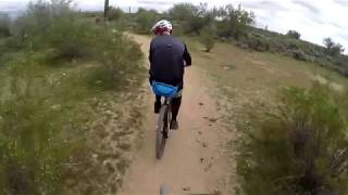
Very nice moderate loop single track trail follows above a large wash and returns the other side. No extended climbs. Two shortcut connectors for shorter rides. Well marked. Either direction good. MTB share the trail, riders from both directions, popular with hikers.

Access Info

Apache Wash Trailhead. Paved parking. No water.

Recent Activity on Trail

Past Week
  • 3 rides
  • 14 miles average
6 Months
  • 131 rides
  • 13 miles avg distance
All
  • 1,401 rides
  • Last: May 30, 2026
c1c2c3c4
January
February
March
April
May
June
July
August
September
October
November
December
update trails status or condition

Apache Wash Loop Trail Reports

statusdatedescription
May 30, 2026 @ 12:09pm (America/Phoenix)
May 30, 2026
Trail was awesome as usual, well maintained and fast and flowy!
Mar 14, 2026 @ 7:33am (America/Phoenix)
Mar 14, 2026
Some of the washes rough crossing. After a big rain last fall. City of Phoenix Park & Receration need to do some trail work.
Dec 13, 2025 @ 10:45am (America/Phoenix)
Dec 13, 2025
Sep 30, 2025 @ 11:07am (America/Phoenix)
Sep 30, 2025
Old lines have been washed/worn away. Lots of sand accumulation. Many deep ruts caused by the flowing water and then also by bikes avoiding the...
Sep 22, 2025 @ 2:48pm (America/Phoenix)
Sep 22, 2025
more »
Status:
on May 30, 2026
Ideal
Avg: 3.82 (28 votes)
Your vote: 0

view (5,985)
close
3D
Trail Conditions
  • Unknown
  • Snow Groomed
  • Snow Packed
  • Snow Covered
  • Snow Cover Partial
  • Freeze/thaw Cycle
  • Icy
  • Prevalent Mud
  • Wet
  • Variable
  • Ideal
  • Dry
  • Very Dry
Trail Flow (Ridden Direction)
Trailforks scans users ridelogs to determine the most popular direction each trail is ridden. A good flowing trail network will have most trails flowing in a single direction according to their intension.
The colour categories are based on what percentage of riders are riding a trail in its intended direction.
  • > 96%
  • > 90%
  • > 80%
  • > 70%
  • > 50%
  • < 50%
  • bi-directional trail
  • no data
Trail Last Ridden
Trailforks scans ridelogs to determine the last time a trail was ridden.
  • < 2 days
  • < 1 week
  • < 2 weeks
  • < 1 month
  • < 6 months
  • > 6 months
Trail Ridden Direction
The intended direction a trail should be ridden.
  • Downhill Only
  • Downhill Primary
  • Both Directions
  • Uphill Primary
  • Uphill Only
  • One Direction
Contribute Details
Colors indicate trail is missing specified detail.
  • Description
  • Photos
  • Description & Photos
  • Videos
Trail Popularity ?
Trailforks scans ridelogs to determine which trails are ridden the most in the last 9 months. Trails are compared with nearby trails in the same city region with a possible 25 colour shades. Think of this as a heatmap, more rides = more kinetic energy = warmer colors.
  • most popular
  • popular
  • less popular
  • not popular
ATV/ORV/OHV Filter
Max Vehicle Width
inches
US Cell Coverage
Legend
cell carrier legend

Radar Time
Activity Recordings
Trailforks uses anonymized public activity data. ?
Activity Recordings
Trailforks uses anonymized public activity data. ?
Personal Heatmap
Activity Types
all / none
Options
2
Date range month
Winter Trails
Warning A routing network for winter maps does not exist. Selecting trails using the winter trails layer has been disabled.
Missing Trails
Most Popular
Least Popular
Trails are colored based on popularity. The more popular a trail is, the more red. Less popular trails trend towards green.
Jump Magnitude Heatmap
Heatmap of where riders jump on trails. Zoom in to see individual jumps, click circles to view jump details.
BC Backroad Status

Service Road Atlas is a free to use, community-driven service for viewing and creating reports on the numerous back-country service roads around B.C. and Alberta.

map legend
Slope Aspect
Direction the slope faces
Flat N NE E SE S SW W NW
Trails Deemphasized
Trails are shown in grey.
disable
Only show trails with no bike usage.
Enable
Suggested Layers
Based on selected activity type

    Save the current map location and zoom level as your default home location whenever this page is loaded.

    Save
        Directions to apache-wash-loop trailhead (33.768640, -112.043990)

        Photos

        42 more »
        39 |
        Sep 27, 2025 @ 1:44pm
        Sep 27, 2025
        41 |
        Sep 27, 2025 @ 1:44pm
        Sep 27, 2025
        40 |
        Sep 27, 2025 @ 1:44pm
        Sep 27, 2025
        49 |
        Sep 19, 2025 @ 9:23am
        Sep 19, 2025

        Videos

        3 more »
        Phoenix Sonoran Preserve | Ringing in the new...
        10:10 | 653 | Jan 4, 2020 , Phoenix
        Apache Wash Loop 2 2 2019 CCW Full ride
        38:59 | 1304 | Feb 3, 2019 , Phoenix
        Apache Wash Casual Ride 6.35mi 10/20/2018
        25:15 | 583 | Nov 7, 2018 , Phoenix

        Routes with this trail

        2.0 6 miles 179 ft 2 Loop
        Easy and flat loop. Good for beginners with the most difficult parts being several wash crossings and some...
        8 miles 212 ft 6 Loop
        Easy loop, starting and ending at the Apache Wash trailhead. (this is my first time using Trailforks and...
        9 miles 264 ft 7
        This is a fitness 9.5 mile loop

        8 Reviews & Comments


        We hope you've been enjoying Trailforks!

        Create a FREE account to view trail comments and much more.

        • By schillingsworthTF Pro TRAILFORKS HTA & contributors
        • #32402 - 12,935 views

        Frequently Asked Questions About Apache Wash Loop

        Where is Apache Wash Loop located?
        Apache Wash Loop is located in Phoenix Sonoran Preserve, Phoenix, Arizona, United States. It is part of the Phoenix Sonoran Preserve trail network. The trailhead is located at coordinates 33.76864, -112.04399.
        How hard is Apache Wash Loop?
        Apache Wash Loop is rated as Green difficulty. The physical rating is Easy. The average grade is 0.1%. The climb difficulty is rated Green.
        What is the elevation gain for Apache Wash Loop?
        Apache Wash Loop has 224 ft of elevation gain. The trail has 203 ft of elevation descent. The elevation ranges from 1,699 ft to 1,809 ft.
        Is Apache Wash Loop a point to point trail?
        Apache Wash Loop is not a point to point trail. The direction is Both Directions. The trail type is singletrack.

        Hit the Trail

        Open in App

        Get this trail on your phone instantly.
        open trail in app

        Download Trail

        Save to wishlist, Garmin & download.
        save the trail

        Find Related Routes

        Find routes and users activities that include this trail.
        find routes for this trail

        You must enter a description before submitting.