more stats
3,508 ft
Distance
20 ft
Climb
-9 ft
Descent
00:05:50
Avg time
10 ft
Altitude change
443 ft
Altitude min
456 ft
Altitude max
446 ft
Altitude start
456 ft
Altitude end
0.298%
Grade
-13.99%
Grade max
7.068%
Grade min
309 ft
Distance climb
187 ft
Distance down
184 ft
Distance flat
00:05:50
Avg time

A-side Details

  • Activities
    • Mountain Bike
    • E-Bike
    • Hike
    • Trail Running
  • Riding Area
    Halfmoon Bay
    Sechelt, British Columbia
  • Difficulty Rating
  • Local Popularity
    5 in Mountain Biking [+]
    • 5 in E-Biking
    • 5 in Trail Running
    • 5 in Hiking
  • Global Ranking
    #180335 in Mountain Biking [+]
    • #178308 in E-Biking
    • #316353 in Trail Running
    • #312439 in Hiking
  • Trail Type
    Singletrack
  • Bike Type
    XC
  • Direction
    Downhill Primary
    Popular Direction Shown
  • Climb Difficulty
    Blue
  • Physical Rating
    Moderate
  • Dogs Allowed
    Yes
  • eBike Allowed
    Yes up to Class 1

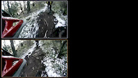
The A-Side trail is a continuation of the B-Side and an entrance into the south side Halfmoon Bay trails. This appears to be a fairly new trail and doesn't yet have a proper bridge or way over the creek that runs across it. However someone has thrown a couple of skinny logs down that you can walk across and there are also a couple of old thik logs that you can get across on. This trail joins Leave It to Beaver and Hwy. 101.

source: ...
Local Trail Association
Traditionally Indigenous Territory

Recent Activity on Trail

Past Week
  • 0 rides
  •  
6 Months
  • 0 rides
  •  
All
  • 28 rides
  • Last: Jul 9, 2023
c1c2c3c4
January
February
March
April
May
June
July
August
September
October
November
December
update trails status or condition

A-side Trail Reports

statusdatedescription
Mar 24, 2024 @ 1:07pm
Mar 24, 2024
Trail all clear
Nov 16, 2023 @ 10:18am
Nov 16, 2023
Riley Falls, Tree, 8" alder log down, easy step over, about midway along trail. No rush. Same for A-Side, 8" alder log down, easy step over.
Nov 16, 2023 @ 10:15am
Nov 16, 2023
B-Side trail has about 5-7 trees across it in 3-4 patches/clusters. All are small, 6-8" but a scramble to get through.
Sep 30, 2020 @ 12:26pm
Sep 30, 2020
Mar 16, 2019 @ 10:51am
Mar 16, 2019
reporter Bridge across Milne creek is damaged and needs to be fixed
more »
Status:
on Mar 24, 2024
Variable
Avg: 3.55 (1 votes)
Your vote: 0

view (180)
close
3D
Trail Conditions
  • Unknown
  • Snow Groomed
  • Snow Packed
  • Snow Covered
  • Snow Cover Partial
  • Freeze/thaw Cycle
  • Icy
  • Prevalent Mud
  • Wet
  • Variable
  • Ideal
  • Dry
  • Very Dry
Trail Flow (Ridden Direction)
Trailforks scans users ridelogs to determine the most popular direction each trail is ridden. A good flowing trail network will have most trails flowing in a single direction according to their intension.
The colour categories are based on what percentage of riders are riding a trail in its intended direction.
  • > 96%
  • > 90%
  • > 80%
  • > 70%
  • > 50%
  • < 50%
  • bi-directional trail
  • no data
Trail Last Ridden
Trailforks scans ridelogs to determine the last time a trail was ridden.
  • < 2 days
  • < 1 week
  • < 2 weeks
  • < 1 month
  • < 6 months
  • > 6 months
Trail Ridden Direction
The intended direction a trail should be ridden.
  • Downhill Only
  • Downhill Primary
  • Both Directions
  • Uphill Primary
  • Uphill Only
  • One Direction
Contribute Details
Colors indicate trail is missing specified detail.
  • Description
  • Photos
  • Description & Photos
  • Videos
Trail Popularity ?
Trailforks scans ridelogs to determine which trails are ridden the most in the last 9 months. Trails are compared with nearby trails in the same city region with a possible 25 colour shades. Think of this as a heatmap, more rides = more kinetic energy = warmer colors.
  • most popular
  • popular
  • less popular
  • not popular
ATV/ORV/OHV Filter
Max Vehicle Width
inches
US Cell Coverage
Legend
cell carrier legend

Radar Time
Activity Recordings
Trailforks uses anonymized public activity data. ?
Activity Recordings
Trailforks uses anonymized public activity data. ?
Personal Heatmap
Activity Types
all / none
Options
2
Date range month
Winter Trails
Warning A routing network for winter maps does not exist. Selecting trails using the winter trails layer has been disabled.
Missing Trails
Most Popular
Least Popular
Trails are colored based on popularity. The more popular a trail is, the more red. Less popular trails trend towards green.
Jump Magnitude Heatmap
Heatmap of where riders jump on trails. Zoom in to see individual jumps, click circles to view jump details.
BC Backroad Status

Service Road Atlas is a free to use, community-driven service for viewing and creating reports on the numerous back-country service roads around B.C. and Alberta.

map legend
Slope Aspect
Direction the slope faces
Flat N NE E SE S SW W NW
Trails Deemphasized
Trails are shown in grey.
disable
Only show trails with no bike usage.
Enable
Suggested Layers
Based on selected activity type

    Save the current map location and zoom level as your default home location whenever this page is loaded.

    Save
        Directions to aside trailhead (49.505270, -123.888360)

        Photos

        5 more »
        259 |
        Feb 29, 2004 @ 7:43pm
        Feb 29, 2004
        238 |
        Feb 29, 2004 @ 7:43pm
        Feb 29, 2004
        33 |
        Nov 16, 2023 @ 10:18am
        Nov 16, 2023
        45 |
        Mar 16, 2019 @ 10:52am
        Mar 16, 2019

        Videos

        3 more »
        Theatre in the Woods
        3:24 | 3134 | Jun 20, 2013 , Sechelt
        Two Animals Spotted at Mount Washington
        3:39 | 1241 | Aug 23, 2012 , Sechelt
        2013_01_14 Hartland Duel Berms
        2:26 | 77 | Jan 14, 2013 , Sechelt

        Routes with this trail

        5.0 23 miles 2,128 ft 35
        Day 1 of Great Explorations - Sunshine Coast Challenge! We start in the beautiful trails of Halfmoon Bay...
        13 miles 1,505 ft 34 Out & Back
        There so many awesome trails in Halfmoon Bay, but trying to connect them up is no easy feat! Park at Trout...

        Reviews / Comments

        No reviews yet, be the first to write a review or ask a question.
        Use trail reports to comment on trail conditions.


        We hope you've been enjoying Trailforks!

        Create a FREE account to view trail comments and much more.

        Nearby Trails

        • By WabmatrixTF Pro CMBTA & contributors
        • #22679 - 1,561 views

        Frequently Asked Questions About A-side

        Where is A-side located?
        A-side is located in Halfmoon Bay, Sechelt, British Columbia, Canada. It is part of the Halfmoon Bay trail network. The trailhead is located at coordinates 49.50527, -123.88836.
        How hard is A-side?
        A-side is rated as Blue difficulty. The physical rating is Moderate. The average grade is 0.298%. The climb difficulty is rated Blue.
        What is the elevation gain for A-side?
        A-side has 20 ft of elevation gain. The trail has 9 ft of elevation descent. The elevation ranges from 443 ft to 456 ft.
        Is A-side a point to point trail?
        A-side is not a point to point trail. The direction is Downhill Primary. The trail type is singletrack.

        Hit the Trail

        Open in App

        Get this trail on your phone instantly.
        open trail in app

        Download Trail

        Save to wishlist, Garmin & download.
        save the trail

        Find Related Routes

        Find routes and users activities that include this trail.
        find routes for this trail

        You must enter a description before submitting.