more stats
2,182 ft
Distance
-229 ft
Descent
00:01:36
Avg time
-231 ft
Altitude change
6,414 ft
Altitude min
6,646 ft
Altitude max
6,646 ft
Altitude start
6,414 ft
Altitude end
-10.6%
Grade
-33.6%
Grade max
-2%
Grade min
2,182 ft
Distance down
00:01:36
Avg time

Blade Runner Details

  • Activities
    • Mountain Bike
  • Riding Area
    Mt. Bachelor Bike Park
    Bend, Oregon
  • Difficulty Rating
  • Local Popularity
    85 in Mountain Biking
  • Global Ranking
    #71972 in Mountain Biking
  • Trail Type
    Singletrack
  • Bike Type
    DH, AM
  • Direction
    Downhill Only
    Popular Direction Shown
  • Physical Rating
    Moderate
  • Season
    July-October
  • Dogs Allowed
    Yes
  • TTFs on Trail
    Skinny
  • Ride in Rain
    Yes
  • Year Opened
    2013
  • Land Owner

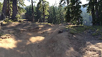
Blade Runner is a more difficult singletrack trail with some technical features. It is a narrower trail than Cone Run or Lava Flow. Low end riders who feel comfortable on FTL and lower Lava Flow can try Blade Runner from the top of the Sunshine lift as the next step in trail progression.

Access Info

Blade Runner can \be accessed from the top of Sunshine lift. More advanced riders can also drop into Blade Runner after descending Rattlesnake trail.

Trail Supporters

  • USFS
    Land Manager

Bike Park

Local Trail Association
  • trail association logo
  • Please consider joining or donating to the local trail association to support
    trail development & maintenance.
Traditionally Indigenous Territory

Recent Activity on Trail

Past Week
  • 5 rides
  • 23 miles average
6 Months
  • 5 rides
  • 23 miles avg distance
All
  • 436 rides
  • Last: Jun 25, 2026
c1c2c3c4
January
February
March
April
May
June
July
August
September
October
November
December
update trails status or condition

Blade Runner Trail Reports

statusdatedescription
Oct 4, 2025 @ 12:26pm (America/Boise)
Oct 4, 2025
Hero dirt, but I crashed on my first lap :(
Sep 4, 2025 @ 10:30am
Sep 4, 2025
Jul 17, 2025 @ 2:32pm
Jul 17, 2025
Dry and riding great!
Jul 6, 2025 @ 2:51pm
Jul 6, 2025
first drop is blind into roots. surprised me and been there done that
Jun 27, 2025 @ 10:07am
Jun 27, 2025
Some water on trail, but riding great!
more »
Status:
on Oct 4, 2025
Ideal
Avg: 3.79 (9 votes)
Your vote: 0

view (4,839)
close
3D
Trail Conditions
  • Unknown
  • Snow Groomed
  • Snow Packed
  • Snow Covered
  • Snow Cover Partial
  • Freeze/thaw Cycle
  • Icy
  • Prevalent Mud
  • Wet
  • Variable
  • Ideal
  • Dry
  • Very Dry
Trail Flow (Ridden Direction)
Trailforks scans users ridelogs to determine the most popular direction each trail is ridden. A good flowing trail network will have most trails flowing in a single direction according to their intension.
The colour categories are based on what percentage of riders are riding a trail in its intended direction.
  • > 96%
  • > 90%
  • > 80%
  • > 70%
  • > 50%
  • < 50%
  • bi-directional trail
  • no data
Trail Last Ridden
Trailforks scans ridelogs to determine the last time a trail was ridden.
  • < 2 days
  • < 1 week
  • < 2 weeks
  • < 1 month
  • < 6 months
  • > 6 months
Trail Ridden Direction
The intended direction a trail should be ridden.
  • Downhill Only
  • Downhill Primary
  • Both Directions
  • Uphill Primary
  • Uphill Only
  • One Direction
Contribute Details
Colors indicate trail is missing specified detail.
  • Description
  • Photos
  • Description & Photos
  • Videos
Trail Popularity ?
Trailforks scans ridelogs to determine which trails are ridden the most in the last 9 months. Trails are compared with nearby trails in the same city region with a possible 25 colour shades. Think of this as a heatmap, more rides = more kinetic energy = warmer colors.
  • most popular
  • popular
  • less popular
  • not popular
ATV/ORV/OHV Filter
Max Vehicle Width
inches
US Cell Coverage
Legend
cell carrier legend

Radar Time
Activity Recordings
Trailforks uses anonymized public activity data. ?
Activity Recordings
Trailforks uses anonymized public activity data. ?
Personal Heatmap
Activity Types
all / none
Options
2
Date range month
Winter Trails
Warning A routing network for winter maps does not exist. Selecting trails using the winter trails layer has been disabled.
Missing Trails
Most Popular
Least Popular
Trails are colored based on popularity. The more popular a trail is, the more red. Less popular trails trend towards green.
Jump Magnitude Heatmap
Heatmap of where riders jump on trails. Zoom in to see individual jumps, click circles to view jump details.
BC Backroad Status

Service Road Atlas is a free to use, community-driven service for viewing and creating reports on the numerous back-country service roads around B.C. and Alberta.

map legend
Slope Aspect
Direction the slope faces
Flat N NE E SE S SW W NW
Trails Deemphasized
Trails are shown in grey.
disable
Only show trails with no bike usage.
Enable
Suggested Layers
Based on selected activity type

    Save the current map location and zoom level as your default home location whenever this page is loaded.

    Save
        Directions to blade-runner trailhead (43.997510, -121.675500)

        Photos

        2 more »
        176 |
        Aug 31, 2017 @ 12:15am
        Aug 31, 2017
        167 |
        Nov 16, 2016 @ 3:13pm
        Nov 16, 2016

        Videos

        1 more »
        Blade Runner
        0:32 | 251 | Nov 8, 2017 , Bend

        Routes with this trail

        2 miles 19 Point to Point
        Built by Dirt Mechanics, professional downhill mountain biker Kyle Jameson, and the dedicated Mt. Bachelor...
        2,106 ft 2 Race
        We are super excited to partner with Mt Bachelor for the Volcanic Enduro. Mt Bachelor is the perfect venue...
        7 miles 2,137 ft 11 Race
        The Loge Full Tilt: Mt Bachelor presented by Race Cascadia. We are stoked to be the feature event at Mt....

        Trail Products

        1 Review & Comments


        We hope you've been enjoying Trailforks!

        Create a FREE account to view trail comments and much more.

        Frequently Asked Questions About Blade Runner

        Where is Blade Runner located?
        Blade Runner is located in Mt. Bachelor Bike Park, Bend, Oregon, United States. It is part of the Mt. Bachelor Bike Park trail network. The trailhead is located at coordinates 43.99751, -121.6755.
        How hard is Blade Runner?
        Blade Runner is rated as Blue difficulty. The physical rating is Moderate. The average grade is 10.6%.
        What is the elevation gain for Blade Runner?
        The trail has 229 ft of elevation descent. The elevation ranges from 6,414 ft to 6,646 ft.
        Is Blade Runner a point to point trail?
        Yes, Blade Runner is a point to point trail. The direction is Downhill Only. The trail type is singletrack.

        Hit the Trail

        Open in App

        Get this trail on your phone instantly.
        open trail in app

        Download Trail

        Save to wishlist, Garmin & download.
        save the trail

        Find Related Routes

        Find routes and users activities that include this trail.
        find routes for this trail

        You must enter a description before submitting.