4,675 ft
Distance
-659 ft
Descent
00:16:02
Avg time
Supporters, Builders, Maintainers & Land Managers of Boogieman Trail

  • Daniel Lui

    since 2012
    Builder
  • Steve Craigdallie
    Builder
  • past supporters

Boogieman Details

  • Activities
    • Mountain Bike
    • Hike
    • Trail Running
  • Riding Area
    Mount Seymour
    North Vancouver, British Columbia
  • Difficulty Rating
  • Voted Difficulty
    Black Diamond (14 votes)
  • Trail Type
    Singletrack
  • Bike Type
    DH
  • Direction
    Downhill Only
    Popular direction shown
  • Dogs Allowed
    Yes
  • TTFs on Trail
    A-Frame, Berm, Bridge, Drop, Jump, Gap Jump, Ladder Bridge, Log Ride, Rock Face, Rock Garden, Roller Coaster, Skinny
  • Ride in Rain
    Yes
  • Global Ranking
    #338 in Mountain Biking [+]
    • #2999 in Trail Running
    • #35 in Hiking
  • Local Popularity
    90 in Mountain Biking [+]
    • 55 in Trail Running
    • 65 in Hiking
  • Land Owner
    District of North Vancouver

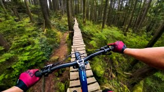
Another North Shore classic filled with mandatory A-frames, skinnies, steep drops and granite TTFs. Brought back from the dead thanks to the NSMBA TAP program, the 5 year rebuild maintains the integrity of the original while bringing the trail experience into the modern era with jumps, rollers, doubles and even a rollercoaster. One of the more difficult Seymour trails due to its exposure, steepness and consequences.

Access Info

Accessed from the Baden Powel trail after Team Pangor.

Local Trail Association
More Stats for Boogieman mountain bike trail trail
  • Altitude change
    -659 ft
  • Altitude min
    703 ft
  • Altitude max
    1,363 ft
  • Altitude start
    1,363 ft
  • Altitude end
    702 ft
  • Grade
    -14.1%
  • Grade max
    -51.8%
  • Grade min
    -2.3%
  • Distance down
    4,675 ft
  • Avg time
    00:16:02
  • Avg reverse time
    00:19:45
  • view trail stats
Status:
on Mar 21, 2023
Ideal
Avg: 4.7 (89 votes)
Your vote: 0

view (9,723)
close
3D
Trail Conditions
  • Unknown
  • Snow Groomed
  • Snow Packed
  • Snow Covered
  • Snow Cover Inadequate
  • Freeze/thaw Cycle
  • Icy
  • Prevalent Mud
  • Wet
  • Variable
  • Ideal
  • Dry
  • Very Dry
Trail Flow (Ridden Direction)
Trailforks scans users ridelogs to determine the most popular direction each trail is ridden. A good flowing trail network will have most trails flowing in a single direction according to their intension.
The colour categories are based on what percentage of riders are riding a trail in its intended direction.
  • > 96%
  • > 90%
  • > 80%
  • > 70%
  • > 50%
  • < 50%
  • bi-directional trail
  • no data
Trail Last Ridden
Trailforks scans ridelogs to determine the last time a trail was ridden.
  • < 2 days
  • < 1 week
  • < 2 weeks
  • < 1 month
  • < 6 months
  • > 6 months
Trail Ridden Direction
The intended direction a trail should be ridden.
  • Downhill Only
  • Downhill Primary
  • Both Directions
  • Uphill Primary
  • Uphill Only
  • One Direction
Contribute Details
Colors indicate trail is missing specified detail.
  • Description
  • Photos
  • Description & Photos
  • Videos
Trail Popularity ?
Trailforks scans ridelogs to determine which trails are ridden the most in the last 9 months. Trails are compared with nearby trails in the same city region with a possible 25 colour shades. Think of this as a heatmap, more rides = more kinetic energy = warmer colors.
  • most popular
  • popular
  • less popular
  • not popular
ATV/ORV/OHV Filter
Max Vehicle Width
inches

Radar Time
x Activity Recordings
Trailforks users anonymized public ridelogs from the past 6 months.
  • mountain biking recent
  • mountain biking (>6 month)
  • hiking (1 year)
  • moto (1 year)
Activity Recordings
Trailforks users anonymized public skilogs from the past 12 months.
  • Downhill Ski
  • Backcountry Ski
  • Nordic Ski
  • Snowmobile
Jump Magnitude Heatmap
Heatmap of where riders jump on trails. Zoom in to see individual jumps, click circles to view jump details.
Trails Deemphasized
Trails are shown in grey.
disable
Only show trails with NO bikes.
enable

Save the current map location and zoom level as your default home location whenever this page is loaded.

Save
      Directions to boogieman trailhead (49.337030, -122.974760)
      update trails status or condition

      Boogieman Trail Reports

      Recent Ridelog Activity on Trail

      Past Week
      • 53 rides
      • 8 miles avg distance
      6 Months
      • 598 rides
      • 8 miles avg distance
      All
      • 9,018 rides
      • Last: Mar 30, 2023

      Photos

      more »
      717 |
      Jan 23, 2018 @ 7:43am
      Jan 23, 2018
      1,576 |
      Nov 6, 2017 @ 8:38pm
      Nov 6, 2017
      1,938 |
      Apr 3, 2016 @ 4:32pm
      Apr 3, 2016
      2,794 |
      Apr 15, 2011 @ 5:36pm
      Apr 15, 2011
      | 11 comments

      Trail Lists

      Routes with this trail

      more »
      titledistance
      Freehub Magazine: Boogieman Loop8 miles
      Seymour Intro211 miles
      Seymour Loop 29 miles
      More Flowy & Jumpy5 miles

      16 Reviews & Comments


      We hope you've been enjoying Trailforks!

      Create a FREE account to view trail comments and much more.

      Videos

      more »
      youtuber Boogieman and Pingu [RAW] Mount Seymour
      1:02 | 2830 | Aug 27, 2018 , North Vancouver
      youtuber FIRST HD5 ride- down the North Shore's HARDEST...
      11:09 | 1297 | Sep 24, 2019 , North Vancouver
      youtuber Boogieman | Mount Seymour, North Vancouver, BC...
      6:52 | 3030 | Mar 31, 2019 , North Vancouver
      youtuber BOOGIEMAN // DOWNHILL MOUNTAIN BIKING // Mount...
      7:01 | 2019 | Mar 2, 2018 , North Vancouver

      Nearby Trails

      • subscribe
      • flag
      • login to download gpx or kml files.