3,255 ft
Distance
60 ft
Climb
-357 ft
Descent
00:07:59
Avg time
Supporters, Builders, Maintainers & Land Managers of Bottletop Trail

Bottletop Details

  • Activities
    • Mountain Bike
    • E-Bike
    • Hike
    • Trail Running
  • Riding Area
    Mount Seymour
    North Vancouver, British Columbia
  • Difficulty Rating
  • Voted Difficulty
    Blue (2 votes)
  • Hiking SAC Scale
    T1 Hiking
  • Trail Type
    Singletrack
  • Bike Type
    AM, XC
  • Direction
    Downhill Primary
    Popular direction shown
  • Physical Rating
    Easy
  • Season
    Year Round
  • Dogs Allowed
    Yes
  • eBike Allowed
    Yes up to Class 1
  • TTFs on Trail
    Berm, Bridge
  • Ride in Rain
    Yes
  • Global Ranking
    #1489 in Mountain Biking [+]
    • #316 in Trail Running
    • #3554 in Hiking
  • Local Popularity
    90 in Mountain Biking [+]
    • 90 in E-Biking
    • 95 in Trail Running
    • 85 in Hiking
  • Land Owner
    Metro Vancouver

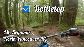
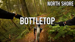
Trail in the Lower Seymour Conservation area - accessible from a couple of points and can be done in either direction. A good option after doing Ned's Atomic Dustbin. Connects to the Seymour Suspension bridge that links Lynn Valley to Seymour.

Access Info

From the bottom of Ned's continue down the trail, and turn right at the 1st intersection. From here continue until you see another trail heading to the left and up a small knoll to Nuggies Bench. From here turn right to Bottle Top which starts out flat then descends. Exit was rerouted to connect to the Seymour suspension bridge.

Local Trail Association
More Stats for Bottletop mountain bike trail trail
  • Altitude change
    -297 ft
  • Altitude min
    337 ft
  • Altitude max
    634 ft
  • Altitude start
    634 ft
  • Altitude end
    338 ft
  • Grade
    -9.1%
  • Grade max
    -47%
  • Grade min
    19.2%
  • Distance climb
    541 ft
  • Distance down
    2,552 ft
  • Distance flat
    161 ft
  • Avg time
    00:07:59
  • Avg reverse time
    00:31:33
  • view trail stats
Status:
on Feb 11, 2025
Snow Packed
Avg: 3.94 (45 votes)
Your vote: 0

view (10,841)
close
3D
Trail Conditions
  • Unknown
  • Snow Groomed
  • Snow Packed
  • Snow Covered
  • Snow Cover Partial
  • Freeze/thaw Cycle
  • Icy
  • Prevalent Mud
  • Wet
  • Variable
  • Ideal
  • Dry
  • Very Dry
Trail Flow (Ridden Direction)
Trailforks scans users ridelogs to determine the most popular direction each trail is ridden. A good flowing trail network will have most trails flowing in a single direction according to their intension.
The colour categories are based on what percentage of riders are riding a trail in its intended direction.
  • > 96%
  • > 90%
  • > 80%
  • > 70%
  • > 50%
  • < 50%
  • bi-directional trail
  • no data
Trail Last Ridden
Trailforks scans ridelogs to determine the last time a trail was ridden.
  • < 2 days
  • < 1 week
  • < 2 weeks
  • < 1 month
  • < 6 months
  • > 6 months
Trail Ridden Direction
The intended direction a trail should be ridden.
  • Downhill Only
  • Downhill Primary
  • Both Directions
  • Uphill Primary
  • Uphill Only
  • One Direction
Contribute Details
Colors indicate trail is missing specified detail.
  • Description
  • Photos
  • Description & Photos
  • Videos
Trail Popularity ?
Trailforks scans ridelogs to determine which trails are ridden the most in the last 9 months. Trails are compared with nearby trails in the same city region with a possible 25 colour shades. Think of this as a heatmap, more rides = more kinetic energy = warmer colors.
  • most popular
  • popular
  • less popular
  • not popular
ATV/ORV/OHV Filter
Max Vehicle Width
inches
US Cell Coverage
Legend
cell carrier legend

Radar Time
x Activity Recordings
Trailforks users anonymized public ridelogs from the past 6 months.
  • mountain biking recent
  • mountain biking (>6 month)
  • hiking (1 year)
  • moto (1 year)
Activity Recordings
Trailforks users anonymized public skilogs from the past 12 months.
  • Downhill Ski
  • Backcountry Ski
  • Nordic Ski
  • Snowmobile
Winter Trails
Warning A routing network for winter maps does not exist. Selecting trails using the winter trails layer has been disabled.
x Missing Trails
Most Popular
Least Popular
Trails are colored based on popularity. The more popular a trail is, the more red. Less popular trails trend towards green.
Jump Magnitude Heatmap
Heatmap of where riders jump on trails. Zoom in to see individual jumps, click circles to view jump details.
Trails Deemphasized
Trails are shown in grey.
disable
Only show trails with NO bikes.
enable

Save the current map location and zoom level as your default home location whenever this page is loaded.

Save
      Directions to bottletop trailhead (49.341800, -122.995050)
      update trails status or condition

      Bottletop Trail Reports

      statusdatedescription
      Feb 11, 2025 @ 1:57pm
      7 hours
      reporter Cleared tree!
      Feb 6, 2025 @ 5:31pm
      Feb 6, 2025
      large tree down. chainsaw required.
      Jan 20, 2025 @ 5:47am
      Jan 20, 2025
      Wet through the steep corners.
      Nov 17, 2024 @ 11:48am
      Nov 17, 2024
      Oct 26, 2024 @ 6:31pm
      Oct 26, 2024
      view all reports »

      Recent Ridelog Activity on Trail

      Past Week
      • 0 rides
      •  
      6 Months
      • 107 rides
      • 14 miles avg distance
      All
      • 1,440 rides
      • Last: Feb 1, 2025

      Photos

      more »
      58 |
      Feb 9, 2024 @ 9:57am
      Feb 9, 2024
      30 |
      Jan 29, 2024 @ 6:22pm
      Jan 29, 2024
      39 |
      Jun 11, 2023 @ 10:24am
      Jun 11, 2023
      79 |
      Nov 27, 2021 @ 12:57pm
      Nov 27, 2021

      Routes with this trail

      more »
      titledistance
      North Shore Triple Crown - Legal37 miles
      North Shore 100 202557 miles
      North Shore 10061 miles
      Seymour/Fromm Traverse - Part 17 miles

      7 Reviews & Comments


      We hope you've been enjoying Trailforks!

      Create a FREE account to view trail comments and much more.

      Videos

      more »
      youtuber Bottletop - North Shore Mountain Biking
      3:18 | 364 | May 7, 2023 , North Vancouver
      Mount Seymour: Bottle Top
      3:36 | 706 | Feb 28, 2021 , North Vancouver
      Vancouver Mount Seymour North Shore -...
      1355 | Sep 14, 2016 , North Vancouver
      Bottletop 2010
      985 | Oct 22, 2011 , North Vancouver
      • By canadakaTF Pro Trailforks & contributors
      • #309 - 17,182 views

      You must enter a description before submitting.