1,152 ft
Distance
4 ft
Climb
-114 ft
Descent
00:03:11
Avg time
Supporters, Builders, Maintainers & Land Managers of Bottom Feeder Trail
  • SIMBS
    Sponsor

Bottom Feeder Details

  • Activities
    • Mountain Bike
    • E-Bike
    • Hike
    • Trail Running
  • Riding Area
    Hartland Mountain Bike Park
    Victoria, British Columbia
  • Difficulty Rating
  • Voted Difficulty
    Blue (1 vote)
  • Trail Type
    Singletrack
  • Bike Type
    AM, XC
  • Direction
    Both Directions
  • Climb Difficulty
    Blue
  • Physical Rating
    Moderate
  • Trail Visibility
    Always easy to follow
  • Dogs Allowed
    Yes
  • eBike Allowed
    Yes up to Class 1
  • TTFs on Trail
    Jump, Wallride
  • Ride in Rain
    Yes
  • Global Ranking
    #36181 in Mountain Biking [+]
    • #8987 in E-Biking
    • #14825 in Trail Running
    • #16254 in Hiking
  • Local Popularity
    85 in Mountain Biking [+]
    • 90 in E-Biking
    • 55 in Trail Running
    • 35 in Hiking
  • Land Owner
    Capital Regional District

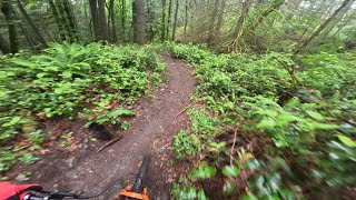
An old logging trail accessible from the middle of Fun trail. Bottom Feeder is also a collector at the ends of Sofa King and Green Ribbon. Usual riding direction is from from Fun down to Crossover. Is a very difficult steep, but doable, climb in the other direction.

Local Trail Association
More Stats for Bottom Feeder mountain bike trail trail
  • Altitude change
    -111 ft
  • Altitude min
    499 ft
  • Altitude max
    610 ft
  • Altitude start
    610 ft
  • Altitude end
    499 ft
  • Grade
    -9.7%
  • Grade max
    -19.5%
  • Grade min
    5.3%
  • Distance climb
    59 ft
  • Distance down
    925 ft
  • Distance flat
    128 ft
  • Avg time
    00:03:11
  • Avg reverse time
    00:05:01
  • view trail stats
Status:
on Jan 5, 2025
Wet
Avg: 3.15 (13 votes)
Your vote: 0

view (8,962)
close
3D
Trail Conditions
  • Unknown
  • Snow Groomed
  • Snow Packed
  • Snow Covered
  • Snow Cover Partial
  • Freeze/thaw Cycle
  • Icy
  • Prevalent Mud
  • Wet
  • Variable
  • Ideal
  • Dry
  • Very Dry
Trail Flow (Ridden Direction)
Trailforks scans users ridelogs to determine the most popular direction each trail is ridden. A good flowing trail network will have most trails flowing in a single direction according to their intension.
The colour categories are based on what percentage of riders are riding a trail in its intended direction.
  • > 96%
  • > 90%
  • > 80%
  • > 70%
  • > 50%
  • < 50%
  • bi-directional trail
  • no data
Trail Last Ridden
Trailforks scans ridelogs to determine the last time a trail was ridden.
  • < 2 days
  • < 1 week
  • < 2 weeks
  • < 1 month
  • < 6 months
  • > 6 months
Trail Ridden Direction
The intended direction a trail should be ridden.
  • Downhill Only
  • Downhill Primary
  • Both Directions
  • Uphill Primary
  • Uphill Only
  • One Direction
Contribute Details
Colors indicate trail is missing specified detail.
  • Description
  • Photos
  • Description & Photos
  • Videos
Trail Popularity ?
Trailforks scans ridelogs to determine which trails are ridden the most in the last 9 months. Trails are compared with nearby trails in the same city region with a possible 25 colour shades. Think of this as a heatmap, more rides = more kinetic energy = warmer colors.
  • most popular
  • popular
  • less popular
  • not popular
ATV/ORV/OHV Filter
Max Vehicle Width
inches
US Cell Coverage
Legend
cell carrier legend

Radar Time
x Activity Recordings
Trailforks users anonymized public ridelogs from the past 6 months.
  • mountain biking recent
  • mountain biking (>6 month)
  • hiking (1 year)
  • moto (1 year)
Activity Recordings
Trailforks users anonymized public skilogs from the past 12 months.
  • Downhill Ski
  • Backcountry Ski
  • Nordic Ski
  • Snowmobile
Winter Trails
Warning A routing network for winter maps does not exist. Selecting trails using the winter trails layer has been disabled.
x Missing Trails
Most Popular
Least Popular
Trails are colored based on popularity. The more popular a trail is, the more red. Less popular trails trend towards green.
Jump Magnitude Heatmap
Heatmap of where riders jump on trails. Zoom in to see individual jumps, click circles to view jump details.
Trails Deemphasized
Trails are shown in grey.
disable
Only show trails with NO bikes.
enable

Save the current map location and zoom level as your default home location whenever this page is loaded.

Save
      Directions to bottom-feeder trailhead (48.520060, -123.465940)
      update trails status or condition

      Bottom Feeder Trail Reports

      Recent Ridelog Activity on Trail

      Past Week
      • 4 rides
      • 6 miles avg distance
      6 Months
      • 134 rides
      • 8 miles avg distance
      All
      • 1,673 rides
      • Last: Jan 11, 2025

      Photos

      more »
      59 |
      Oct 24, 2017 @ 3:57pm
      Oct 24, 2017
      49 |
      Oct 24, 2017 @ 3:56pm
      Oct 24, 2017
      47 |
      Oct 24, 2017 @ 3:55pm
      Oct 24, 2017
      45 |
      Oct 24, 2017 @ 3:55pm
      Oct 24, 2017

      Routes with this trail

      more »
      titledistance
      Kickduro5 miles
      Hartland Advanced Route8 miles
      Who's Yer Daddy / Night Shift7 miles
      Lots of Double Blacks7 miles

      Reviews / Comments

      No reviews yet, be the first to write a review or ask a question.
      Use trail reports to comment on trail conditions.


      We hope you've been enjoying Trailforks!

      Create a FREE account to view trail comments and much more.

      Videos

      more »
      Bottom Feeder (Down) - June 2nd 2024
      0:14 | 40 | Jun 6, 2024 , Victoria
      Bottom Feeder (Climb) at Hartland Bike Park in...
      4:00 | 76 | Nov 8, 2023 , Victoria
      Bottom Feeder (Descent) at Hartland Bike Park,...
      2:08 | 38 | Nov 3, 2023 , Victoria
      • By KZ-Powned & contributors
      • #1215 - 2,570 views

      You must enter a description before submitting.