more stats
4,442 ft
Distance
5 ft
Climb
-711 ft
Descent
00:14:34
Avg time
-707 ft
Altitude change
2,036 ft
Altitude min
2,748 ft
Altitude max
2,743 ft
Altitude start
2,037 ft
Altitude end
-15.9%
Grade
-36.8%
Grade max
5.2%
Grade min
135 ft
Distance climb
4,268 ft
Distance down
39 ft
Distance flat
00:14:34
Avg time

CBC Details

  • Activities
    • Mountain Bike
    • E-Bike
    • Hike
    • Trail Running
  • Riding Area
    Mount Seymour
    North Vancouver, British Columbia
  • Difficulty Rating
  • Voted Difficulty
    Black Diamond (13 votes)
  • Local Popularity
    90 in Mountain Biking [+]
    • 80 in E-Biking
    • 75 in Trail Running
    • 60 in Hiking
  • Global Ranking
    #163 in Mountain Biking [+]
    • #1437 in E-Biking
    • #149 in Trail Running
    • #348 in Hiking
  • Trail Type
    Singletrack
  • Bike Type
    DH
  • Dogs Allowed
    Yes
  • eBike Allowed
  • TTFs on Trail
    A-Frame, Berm, Bridge, Ladder Bridge, Log Ride, Rock Garden, Roller Coaster, Skinny, Wallride, Other
  • Ride in Rain
    Yes
  • Land Owner
    Metro Vancouver

Please review the LSCR website for the official trail status: https://metrovancouver.org/services/regional-parks/park/lower-seymour-conservation-reserve

This trail still sees winter closures to protect the trail from impact.

Access Info

Park at P1 in BC Parks, ride down the road to the trail access at the radio tower roads. The trail starts at the corner of the two radio tower gravel roads.

Disclaimer

Please review the LSCR website for the official trail status.

Trail Supporters
  • Stuart Kerr
    2012
    Sponsor
Local Trail Association

Recent Activity on Trail

Past Week
  • 8 rides
  • 8 miles average
6 Months
  • 177 rides
  • 10 miles avg distance
All
  • 2,612 rides
  • Last: Jun 11, 2026
c1c2c3c4
January
February
March
April
May
June
July
August
September
October
November
December
update trails status or condition

CBC Trail Reports

statusdatedescription
May 24, 2026 @ 7:38am (America/Vancouver)
May 24, 2026
May 10, 2026 @ 2:37pm (America/Vancouver)
May 10, 2026
May 5, 2026 @ 4:37pm (America/Vancouver)
May 5, 2026
Open! some loose sections but running nice.
May 5, 2026 @ 1:44pm (America/Vancouver)
May 5, 2026
May 3, 2026 @ 8:01pm (America/Vancouver)
May 3, 2026
the entrance has the typical orange road sign for work being done, but no other signage. nothing on the metro van page linked either. part way...
more »
Status:
on May 24, 2026
Dry
Avg: 3.99 (129 votes)
Your vote: 0

view (11,534)
close
3D
Trail Conditions
  • Unknown
  • Snow Groomed
  • Snow Packed
  • Snow Covered
  • Snow Cover Partial
  • Freeze/thaw Cycle
  • Icy
  • Prevalent Mud
  • Wet
  • Variable
  • Ideal
  • Dry
  • Very Dry
Trail Flow (Ridden Direction)
Trailforks scans users ridelogs to determine the most popular direction each trail is ridden. A good flowing trail network will have most trails flowing in a single direction according to their intension.
The colour categories are based on what percentage of riders are riding a trail in its intended direction.
  • > 96%
  • > 90%
  • > 80%
  • > 70%
  • > 50%
  • < 50%
  • bi-directional trail
  • no data
Trail Last Ridden
Trailforks scans ridelogs to determine the last time a trail was ridden.
  • < 2 days
  • < 1 week
  • < 2 weeks
  • < 1 month
  • < 6 months
  • > 6 months
Trail Ridden Direction
The intended direction a trail should be ridden.
  • Downhill Only
  • Downhill Primary
  • Both Directions
  • Uphill Primary
  • Uphill Only
  • One Direction
Contribute Details
Colors indicate trail is missing specified detail.
  • Description
  • Photos
  • Description & Photos
  • Videos
Trail Popularity ?
Trailforks scans ridelogs to determine which trails are ridden the most in the last 9 months. Trails are compared with nearby trails in the same city region with a possible 25 colour shades. Think of this as a heatmap, more rides = more kinetic energy = warmer colors.
  • most popular
  • popular
  • less popular
  • not popular
ATV/ORV/OHV Filter
Max Vehicle Width
inches
US Cell Coverage
Legend
cell carrier legend

Radar Time
Activity Recordings
Trailforks uses anonymized public activity data. ?
Activity Recordings
Trailforks uses anonymized public activity data. ?
Personal Heatmap
Activity Types
all / none
Options
2
Date range month
Winter Trails
Warning A routing network for winter maps does not exist. Selecting trails using the winter trails layer has been disabled.
Missing Trails
Most Popular
Least Popular
Trails are colored based on popularity. The more popular a trail is, the more red. Less popular trails trend towards green.
Jump Magnitude Heatmap
Heatmap of where riders jump on trails. Zoom in to see individual jumps, click circles to view jump details.
BC Backroad Status

Service Road Atlas is a free to use, community-driven service for viewing and creating reports on the numerous back-country service roads around B.C. and Alberta.

map legend
Slope Aspect
Direction the slope faces
Flat N NE E SE S SW W NW
Trails Deemphasized
Trails are shown in grey.
disable
Only show trails with no bike usage.
Enable
Suggested Layers
Based on selected activity type

    Save the current map location and zoom level as your default home location whenever this page is loaded.
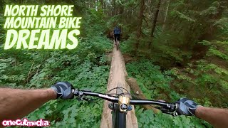
    Save
        Directions to cbc trailhead (49.353260, -122.958600)

        Photos

        593 more »
        622 |
        Nov 18, 2015 @ 10:07pm
        Nov 18, 2015
        1,468 |
        Feb 20, 2010 @ 6:51pm
        Feb 20, 2010
        205 |
        Jul 1, 2023 @ 10:10pm
        Jul 1, 2023
        192 |
        Jul 1, 2023 @ 10:05pm
        Jul 1, 2023

        Videos

        95 more »
        youtuber Top 5 FAVOURITE MTB Trails of 2023!
        23:48 | 413 | Feb 6, 2024 , North Vancouver
        youtuber This Prototype is the Future, and it's
        17:49 | 378 | Jun 8, 2023 , North Vancouver
        youtuber E-bikes Are For Old People! - Seymour Mtn. -...
        16:59 | 820 | Sep 19, 2021 , North Vancouver
        youtuber North Shore Mountain Biking Dreams in North...
        11:55 | 370 | Oct 7, 2023 , North Vancouver

        Trail Lists

        Routes with this trail

        3.8 37 miles 7,397 ft 25 Point to Point
        North Shore Tripple crown No unsanctioned trails
        5.0 59 miles 9,478 ft 31
        Unlike previous versions, this is a loop and goes as high and as much off road as possible.
        12 miles 3,080 ft 15 Loop
        Seymour long ride, follow your heart

        32 Reviews & Comments


        We hope you've been enjoying Trailforks!

        Create a FREE account to view trail comments and much more.

        • By canadakaTF Pro Trailforks & contributors
        • #197 - 48,632 views

        Frequently Asked Questions About CBC

        Where is CBC located?
        CBC is located in Mount Seymour, North Vancouver, British Columbia, Canada. It is part of the Mount Seymour trail network. The trailhead is located at coordinates 49.35326, -122.9586.
        How hard is CBC?
        CBC is rated as Black Diamond difficulty. The average grade is 15.9%.
        What is the elevation gain for CBC?
        CBC has 5 ft of elevation gain. The trail has 711 ft of elevation descent. The elevation ranges from 2,036 ft to 2,748 ft.
        How long is CBC?
        CBC is 4,442 ft long. The trail type is singletrack.

        Hit the Trail

        Open in App

        Get this trail on your phone instantly.
        open trail in app

        Download Trail

        Save to wishlist, Garmin & download.
        save the trail

        Find Related Routes

        Find routes and users activities that include this trail.
        find routes for this trail

        You must enter a description before submitting.