more stats
1,191 ft
Distance
-55 ft
Descent
836 ft
High Point
-56 ft
Altitude change
780 ft
Altitude min
836 ft
Altitude start
781 ft
Altitude end
-4.7%
Grade
-12.9%
Grade max
0.7%
Grade min
794 ft
Distance down
322 ft
Distance flat

Closing Time Details

  • Activities
    • Mountain Bike
    • E-Bike
  • Riding Area
    Galbraith
    Bellingham, Washington
  • Difficulty Rating
  • Local Popularity
    100 in Mountain Biking
  • Trail Type
    Singletrack
  • Direction
    One Direction[+]
    Popular Direction Shown
    • One Direction for E-Biking
  • Trail Visibility
    Always easy to follow
  • Dogs Allowed
    Yes
  • eBike Allowed
    Yes up to Class 1
  • TTFs on Trail
    Bridge
  • Year Opened
    2025

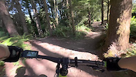
Closing Time gives you one last chance for singletrack as you are rolling back to the Southside parking lot. This one-direction trail can be accessed from Last Call and features a handcut trail that parallels the road featuring a small rock roll (with ride around), an abandoned car, and a bridge right at the end before popping back up onto Galbraith Lane. This trail was built over the course of several months in 2025 by WMBC volunteers and opened in January 2026.

Trail Supporters
Local Trail Association
Traditionally Indigenous Territory

Recent Activity on Trail

Past Week
  • 156 rides
  • 12 miles average
6 Months
  • 2,386 rides
  • 10 miles avg distance
All
  • 2,389 rides
  • Last: Jun 27, 2026
c1c2c3c4
January
February
March
April
May
June
July
August
September
October
November
December
Status:
on Jun 21, 2026
Dry
Avg: 4.1 (3 votes)
Your vote: 0

view (6,398)
close
3D
Trail Conditions
  • Unknown
  • Snow Groomed
  • Snow Packed
  • Snow Covered
  • Snow Cover Partial
  • Freeze/thaw Cycle
  • Icy
  • Prevalent Mud
  • Wet
  • Variable
  • Ideal
  • Dry
  • Very Dry
Trail Flow (Ridden Direction)
Trailforks scans users ridelogs to determine the most popular direction each trail is ridden. A good flowing trail network will have most trails flowing in a single direction according to their intension.
The colour categories are based on what percentage of riders are riding a trail in its intended direction.
  • > 96%
  • > 90%
  • > 80%
  • > 70%
  • > 50%
  • < 50%
  • bi-directional trail
  • no data
Trail Last Ridden
Trailforks scans ridelogs to determine the last time a trail was ridden.
  • < 2 days
  • < 1 week
  • < 2 weeks
  • < 1 month
  • < 6 months
  • > 6 months
Trail Ridden Direction
The intended direction a trail should be ridden.
  • Downhill Only
  • Downhill Primary
  • Both Directions
  • Uphill Primary
  • Uphill Only
  • One Direction
Contribute Details
Colors indicate trail is missing specified detail.
  • Description
  • Photos
  • Description & Photos
  • Videos
Trail Popularity ?
Trailforks scans ridelogs to determine which trails are ridden the most in the last 9 months. Trails are compared with nearby trails in the same city region with a possible 25 colour shades. Think of this as a heatmap, more rides = more kinetic energy = warmer colors.
  • most popular
  • popular
  • less popular
  • not popular
ATV/ORV/OHV Filter
Max Vehicle Width
inches
US Cell Coverage
Legend
cell carrier legend

Radar Time
Activity Recordings
Trailforks uses anonymized public activity data. ?
Activity Recordings
Trailforks uses anonymized public activity data. ?
Personal Heatmap
Activity Types
all / none
Options
2
Date range month
Winter Trails
Warning A routing network for winter maps does not exist. Selecting trails using the winter trails layer has been disabled.
Missing Trails
Most Popular
Least Popular
Trails are colored based on popularity. The more popular a trail is, the more red. Less popular trails trend towards green.
Jump Magnitude Heatmap
Heatmap of where riders jump on trails. Zoom in to see individual jumps, click circles to view jump details.
BC Backroad Status

Service Road Atlas is a free to use, community-driven service for viewing and creating reports on the numerous back-country service roads around B.C. and Alberta.

map legend
Slope Aspect
Direction the slope faces
Flat N NE E SE S SW W NW
Trails Deemphasized
Trails are shown in grey.
disable
Only show trails with no bike usage.
Enable
Suggested Layers
Based on selected activity type

    Save the current map location and zoom level as your default home location whenever this page is loaded.

    Save
        Directions to closing-time trailhead (48.708070, -122.422120)

        Photos

        0 more »
        40 |
        Apr 13, 2026 @ 3:19pm
        Apr 13, 2026

        Videos

        1 more »
        LetsFinishDiz
        0:00 | 11 | Jun 24, 2026 , Bellingham

        Routes with this trail

        7 miles 1,183 ft 9
        Intermediate family flow ride
        24 miles 4,651 ft 39 Loop
        WMBC's Whatcom World Cup 2026 (https://www.trailforks.com/series/456/) all routes in one. Think of this as...
        42 miles 6,858 ft 40

        1 Review & Comments


        We hope you've been enjoying Trailforks!

        Create a FREE account to view trail comments and much more.

        Frequently Asked Questions About Closing Time

        Where is Closing Time located?
        Closing Time is located in Galbraith, Bellingham, Washington, United States. It is part of the Galbraith trail network. The trailhead is located at coordinates 48.70807, -122.42212.
        How hard is Closing Time?
        Closing Time is rated as Green difficulty. The average grade is 4.7%.
        What is the elevation gain for Closing Time?
        The trail has 55 ft of elevation descent. The elevation ranges from 780 ft to 836 ft.
        Is Closing Time a point to point trail?
        Yes, Closing Time is a point to point trail. The direction is One Direction. The trail type is singletrack.

        Hit the Trail

        Open in App

        Get this trail on your phone instantly.
        open trail in app

        Download Trail

        Save to wishlist, Garmin & download.
        save the trail

        Find Related Routes

        Find routes and users activities that include this trail.
        find routes for this trail

        You must enter a description before submitting.